


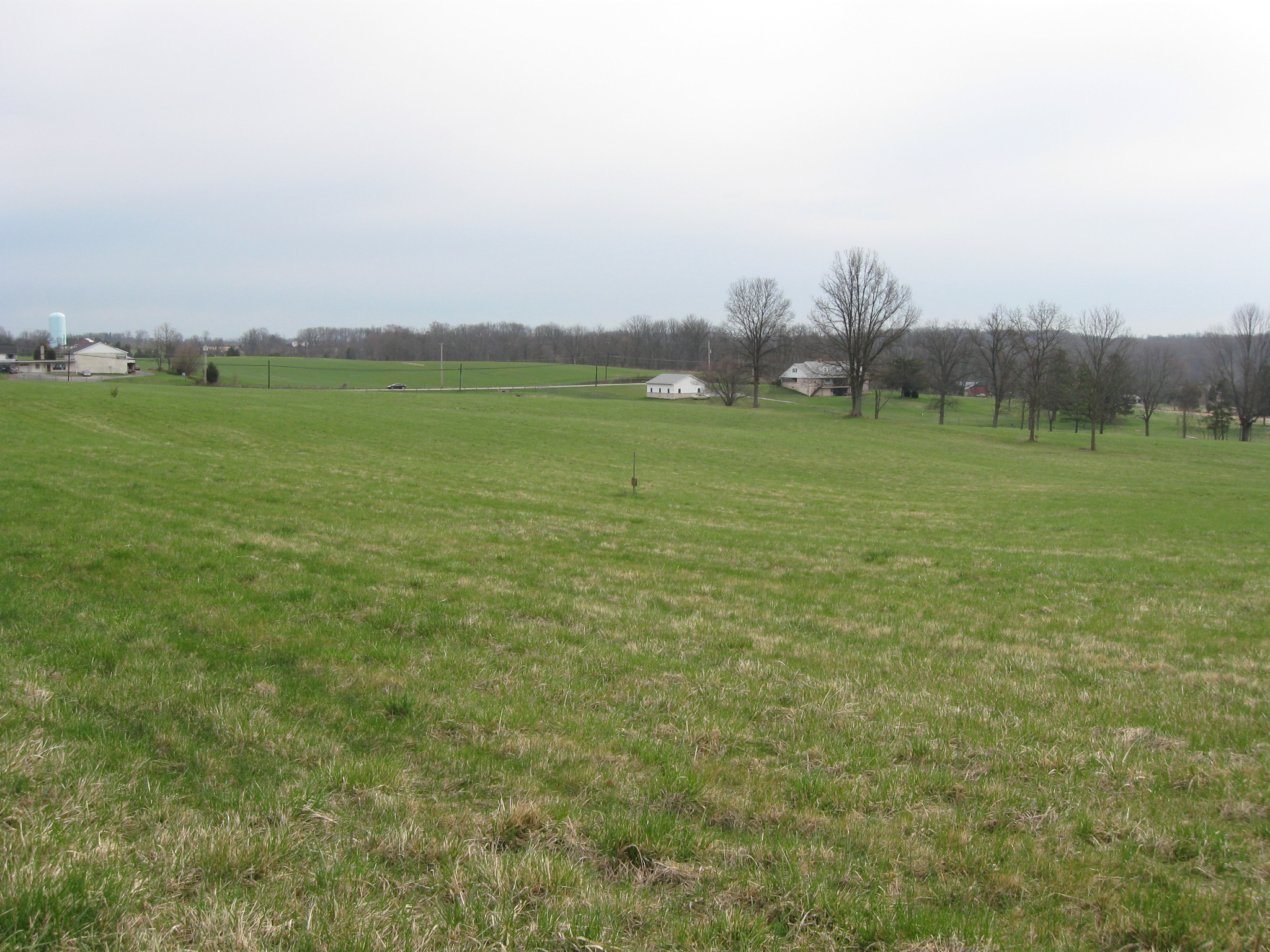
In our two previous posts on Benner’s Hill we have discussed the Confederate artillery placement. Today we will describe the Union artillery that would fire to here at Cemetery Hill on the right (marked by the light green/light blue water tank) and Culp’s Hill on the left (topped by the observation tower). This view was taken facing southwest at approximately 10:15 AM on Friday, April 10, 2009.
Benner’s Hill is a spot in Gettysburg National Military Park not frequently visited by the average student of Gettysburg. Gettysburg Licensed Battlefield Guide Tony DeLacy is our host for the series on the hill, and the action that occurred here on July 2, 1863. In our first Benner’s Hill post, we covered the the basic layout of the hill. In our second post we covered the alignment of the Confederate artillery by Major Joseph Latimer. In today’s final Benner’s Hill post, we discuss the action on Benner’s Hill.
To contact Tony Delacy click here to reveal his email address
See our first post on Benner’s Hill on April 8, 2008.
To see other posts by Gettysburg Licensed Battlefield Guides, click here.

This map shows the location of the videos that we shot for this post. Videos #s 1, 8, and 9 were taken near the turnaround area at the south end of Benner’s Hill. Videos #2 and #3 were taken just north of the turnaround. Videos #4-#7 were taken near the National Park Service wayside marker. Video #10 was taken at the south end of Benner’s Hill near the position of Raine’s Battery. This map was created facing east at approximately 8:35 PM on Wednesday, May 13, 2009.

Our host for the Benner’s Hill post is Gettysburg Licensed Battlefield Guide Tony DeLacy. Tony came to Gettysburg from the Philadelphia area, and has been a Licensed Battlefield Guide since 2004. This view was taken facing north at approximately 9:00 AM on Friday, April 10, 2009.
In Video #7 (Videos #1-#6) were seen in our previous Benner’s Hill posts), Gettysburg Licensed Battlefield Guide Tony DeLacy discusses the position of the Union artillery at East Cemetery Hill, Culp’s Hill, and Stevens’ Knoll. This view was taken facing southwest at approximately 10:15 AM on Friday, April 10, 2009.

Tony stated that approximately 40 artillery pieces were aimed at Benner’s Hill from Cemetery Hill (shown by the light blue/light green water tank on the left and the red brick Evergreen Cemetery Gatehouse to the left of the telephone poll), Stevens’ Knoll and Culp’s Hill. Stevens’ Knoll (McKnight’s Hill) and Culp’s Hill are not shown in this view. This view was taken facing southwest at approximately 9:00 AM on Friday, April 10, 2009.
In Video #8, Tony discusses the heavy fire taken by Latimer’s Artillery Battalion between approximately 4:00 PM and 6:00 PM on July 2, 1863. This view was taken facing southwest to south at approximately 10:15 AM on Friday, April 10, 2009.

Lieutenant Robert Stiles of Cabell’s Artillery Battalion wrote, “Never, before, or after, did I see fifteen or twenty guns in such a condition of wreck and destruction as this battalion was…” This view was taken facing north at approximately 10:15 AM on Friday, April 10, 2009.

“…It had been hurled backward, as it were, by the very weight and impact of metal from the position it had occupied on the crest of the little ridge,…” This view was taken facing north at approximately 10:15 AM on Friday, April 10, 2009.
“…into a saucer-shaped depression behind it; and such a scene it presented– guns dismounted and disabled, carriages splintered and crushed, ammunition chests exploded, limbers upset,…” This view was taken facing northeast at approximately 10:15 AM on Friday, April 10, 2009.

“…wounded horses plunging and kicking, dashing out the brains of men tangled in the harness; while cannoneers with pistols were crawling around through the wreck shooting the struggling horses to save the lives of wounded men.” This view was taken facing northeast at approximately 10:15 AM on Friday, April 10, 2009.
In Video #9, Tony explains that Major Joseph Latimer was mortally wounded during the action on July 2, 1863. This view was taken facing west at approximately 10:15 AM on Friday, April 10, 2009.
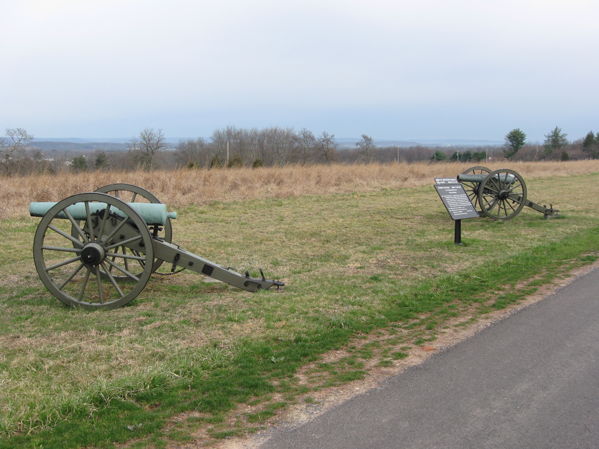
To support the attack of Edward Johnson’s Confederate division on Culp’s Hill, Latimer was ordered to order two guns of Raine’s Battery and two guns of Dement’s Maryland Battery (marked by the guns shown here) on Benner’s Hill. Latimer rode to the crest of the hill to supervise the four guns, and a shell exploded near him, killing his horse, and wounding Latimer in the right arm. The horse fell on Latimer, and his fellow artillerymen finally managed to pull him out from under the horse. This view was taken facing northwest at approximately 10:15 AM on Friday, April 10, 2009.

Latimer’s arm was amputated, and he survived the trip back to Virginia. On August 1, 1863 in Harrisonburg, Virginia, he was fading fast and asked by his attending physician if he feared death. “No,” the nineteen year old answered, “for my trust is in God.” He died that day and the “Boy Major” is buried in Harrisonburg’s Woodbine Cemetery. This view was taken facing southwest at approximately 10:15 AM on Friday, April 10, 2009.
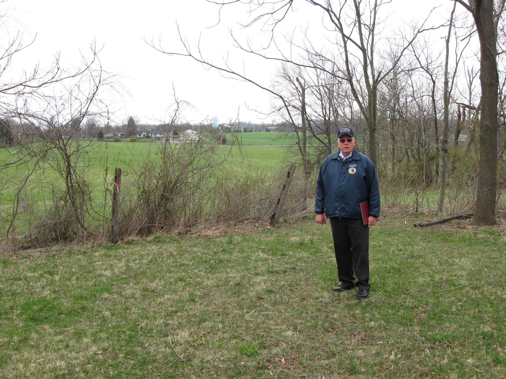
Licensed Battlefield Guide Tony Delacy is standing on the south end of Benner’s Hill. The saucer-like depression to which Latimer’s Battalion retreated is behind Tony. This view was taken facing northeast at approximately 10:15 AM on Friday, April 10, 2009.
In Video #10, Tony explains how Edward Johnson’s infantry would move towards Culp’s Hill, and Culp’s Hill’s relationship to the south end of Benner’s Hill where Raine’s Battery position was located. This view was taken facing northeast to southwest at approximately 10:15 AM on Friday, April 10, 2009.
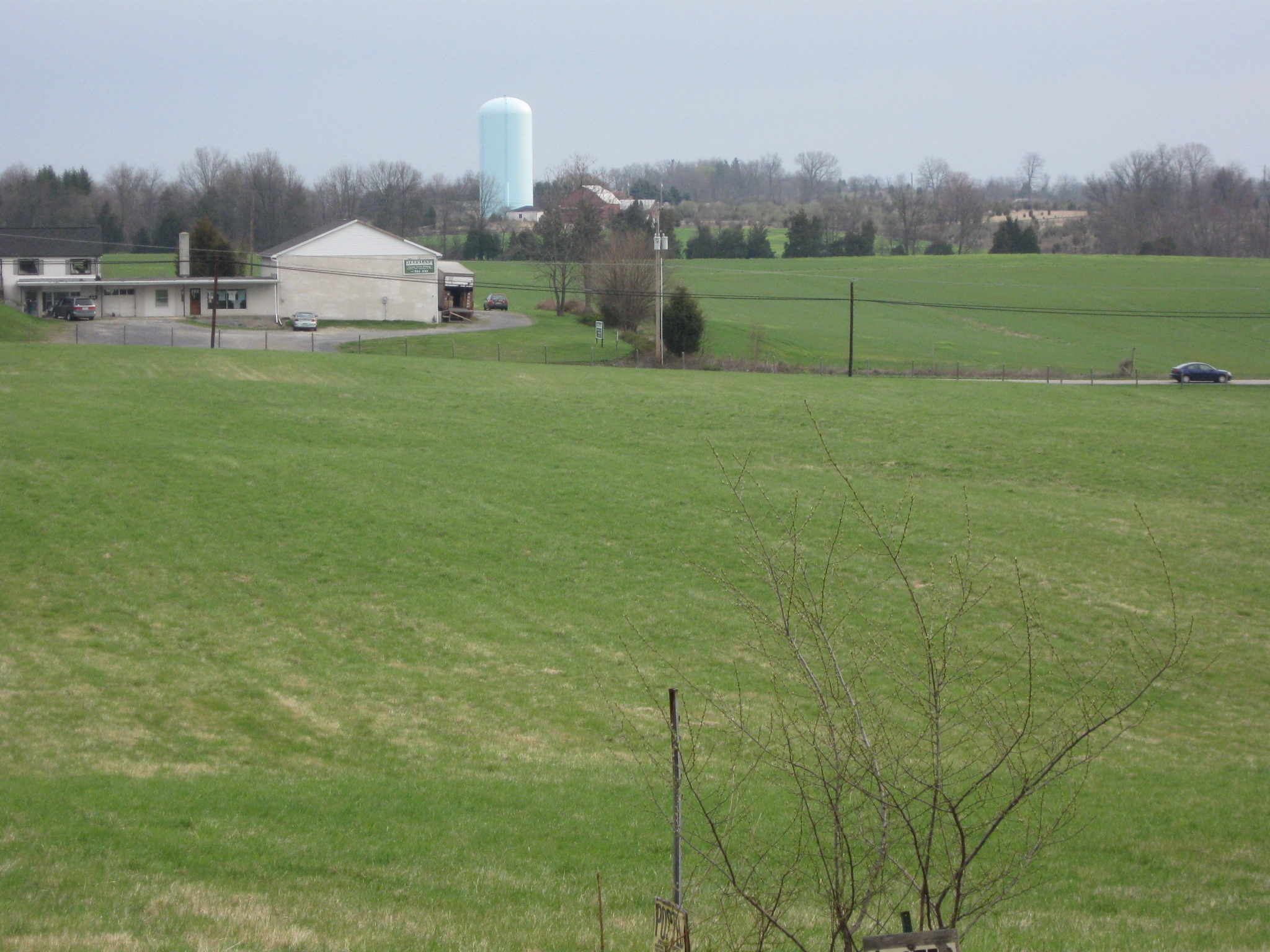
The light green/light blue water tank that marks Camp Letterman or Hospital Hill near the York Road. This view was taken facing northeast at approximately 10:15 AM on Friday, April 10, 2009.

Tony Delacy is standing by the guns marking the position of Raine’s Battery at the south end of Benner’s Hill. Culp’s Hill is barely visible in the left background. This view was taken facing southwest at approximately 10:15 AM on Friday, April 10, 2009.