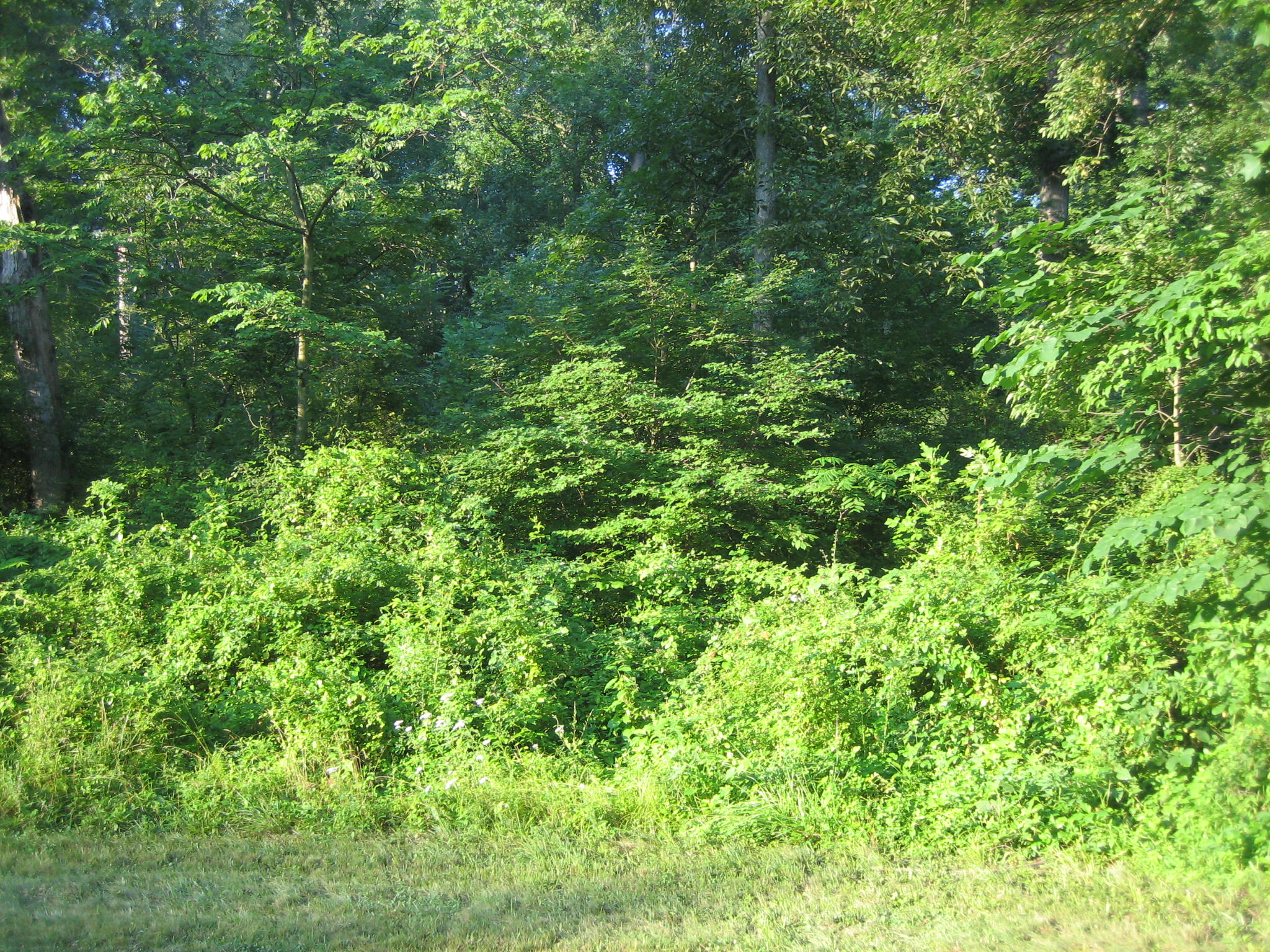
The undergrowth in the woods of Gettysburg National Military Park is out of control. The park has made significant strides in attempting to put the vegetation back to where it was in 1863, so visitors can better understand the fighting. In the woods, however, this goal is far from being accomplished. This picture shows the position of Jones’ Virginia brigade as they began their climb up Culp’s Hill on July 2nd and July 3rd, 1863. This view was taken from the northeast facing southwest at approximately 7:45 AM on Wednesday, July 16, 2008.
Gettysburg National Military Park should be proud of its role in battlefield preservation. Recently, the attempt to place the vegetation of the battlefield closer to what it looked like in 1863 generated a significant amount of controversy. Environmentalists were very concerned about the tree removal on the battlefield and, it appears, ignored the fact that over 14,000 trees and bushes were being replanted on the field at the same time. The Superintendent and his staff were courageous in their attempts to have the battlefield closer to its mandate to be used for military study.
However, much remains to be done. Restoring the battlefield to the way it looked in 1863 also means removing most of the undergrowth from the battlefield. Visitors in the summer have the impression that the Battle of Gettysburg was akin to jungle warfare. Military groups cannot understand what the soldiers saw, and how they reacted to events if they can’t see very far through the woods. Earthworks are covered, and are not available to show groups why they were built in certain locations. The value of a military crest for defense is obscured.
Safety is also a concern. The Park Service “removed” hundreds of deer a decade ago to help reduce lyme disease which lives in the ticks on the deer. But what about the ticks in this undergrowth encountered by visitors on their own, or when led through the woods by National Park Service Rangers as part of their programs? When you killed off the deer, you also took out of the park the animals that were eating the undergrowth.
More than a few visitors have commented the Licensed Battlefield Guides and National Park Service Rangers about the possibility of fire in the park. Of course they are told, that we’ve never had a large fire at Gettysburg, but does that mean it won’t happen? Have we really had enough rain this year to prevent fire?
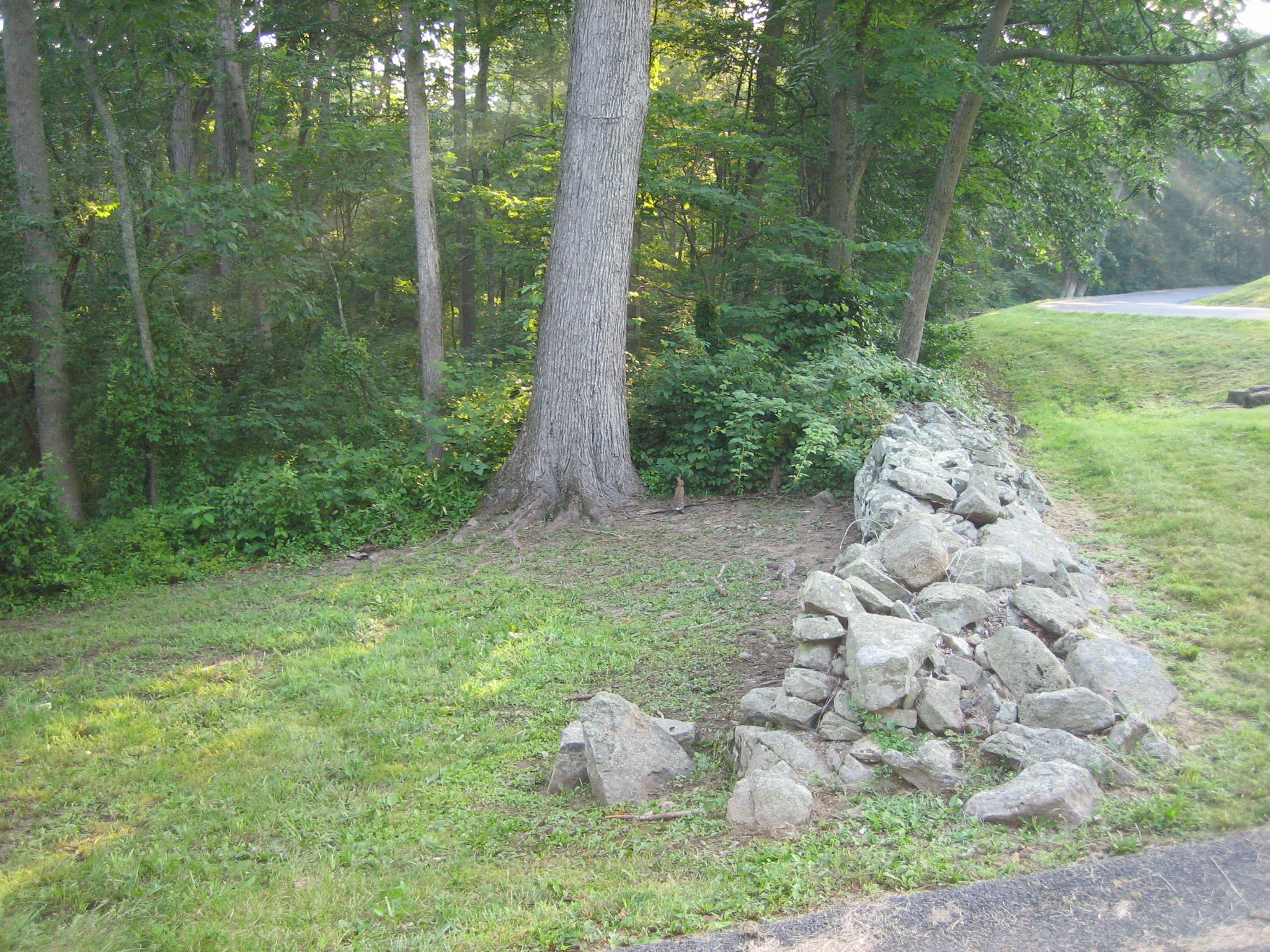
Farming practices in the 1860s were much different than today. The wooden fences that the Park Service are reconstructing on the battlefield were used to fence animals out of farmers crops. Animals were allowed to roam through the woods during the day, and they would have ate the undergrowth. The soldiers mostly wrote about “open” woods in 1863. This stone wall is at the position near Jones’ Brigade plaque on East Confederate Avenue. The Park Service has cut the grass to the right of the wall, and near the road, but on the left side of the wall, the undergrowth is untouched. This view was taken from the northwest facing southeast at approximately 7:45 AM on Wednesday, July 16, 2008.
One of the main purposes of Gettysburg National Military Park was to preserve the battlefield for military study. The United States and the Confederate States movements were to be shown so the military could get a full picture of what happened. However, if one can’t go up Culp’s Hill as the Confederates did in warm weather, are we in danger of only showing one side’s actions? What obstacles did the Confederates face here? Some might say that we should come back in the winter. But of course, that is not when visitation is at its highest. We would like the opportunity to show more visitors how the the Confederates advanced here. Showing this only in the winter will reach few of the park’s visitors. Again, this is a view from Jones’ position at the bottom of Culp’s Hill, looking up to the top of the hill where the observation tower is located. This view was taken from the northeast facing southwest at approximately 7:45 AM on Wednesday, July 16, 2008.
There is a military group that is visiting Gettysburg this week that wants a Licensed Battlefield Guide to show them Culp’s Hill in detail. But when you bring them to this spot on lower Culp’s Hill, or Spangler’s Hill, to show them the value of placing earthworks at this position on the military crest, are they going to understand? How can we show these young men and women, at a time of war, how the 137th New York had Confederates in a cross fire from this position the evening of July 2nd? Will this really help these young men and women prepare for what they might face on battlefields in other parts of the world? This view was taken from the southwest facing northeast at approximately 7:45 AM on Tuesday, July 8, 2008.
The works in front of the 109th Pennsylvania, and many other United States positions are covered with the undergrowth. Some say that this is to protect them from people walking on them and destroying them. So we come to that conflict between preservation and interpretation. How can one interpret this site and have any idea of what the United States troops saw here? What do we need to clear this area of undergrowth? Animals? Chemicals? A controlled burn? This view was taken from the southwest facing northeast at approximately 7:45 AM on Wednesday, July 16, 2008.
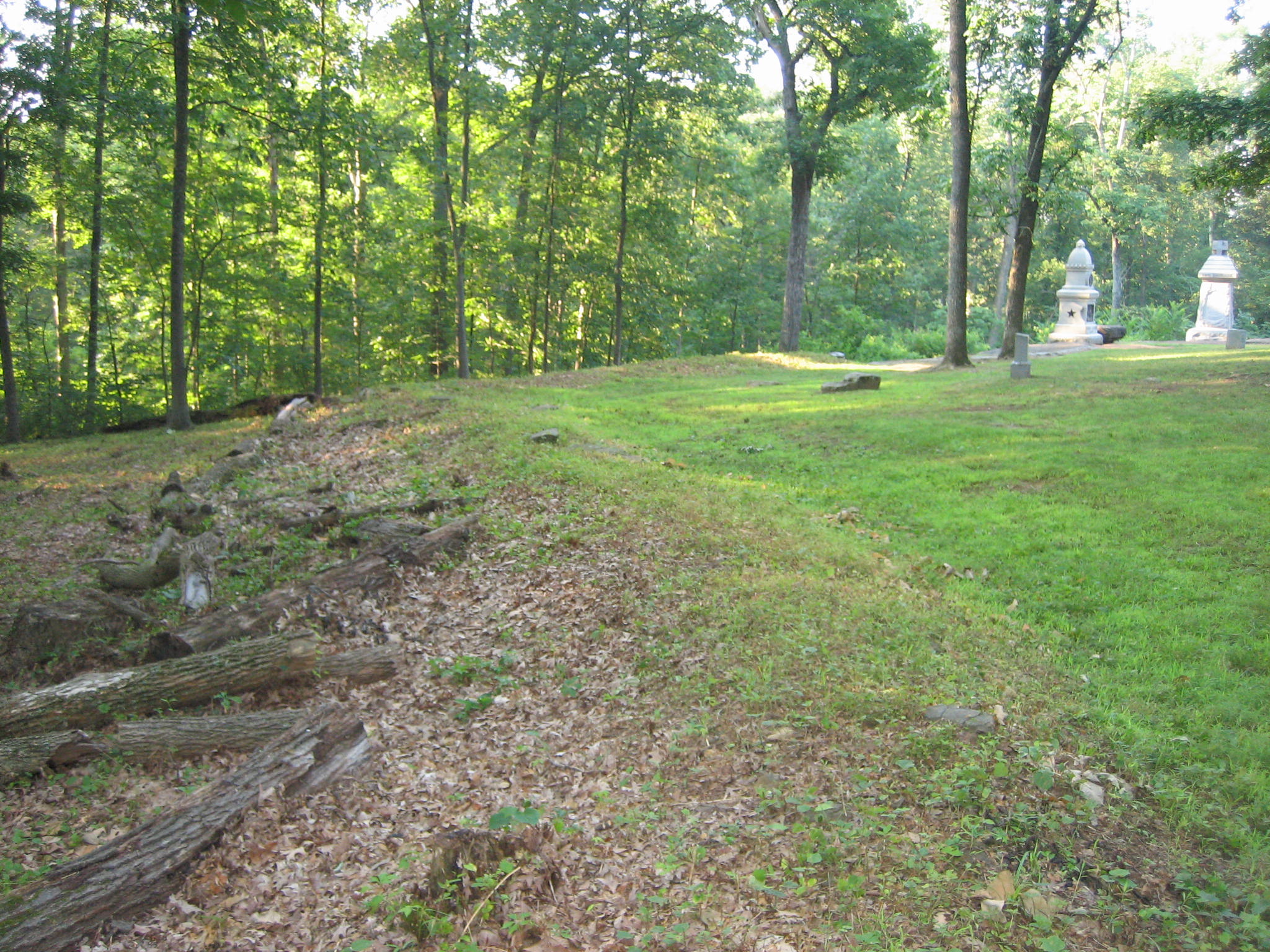
Here is a small portion of the earthworks that have been cleared. Obviously concern for earthwork protection isn’t a problem here. And the reason this area has probably been cleared is because a famous photograph of the Culp’s Hill earthworks was taken of this section following the battle. So shouldn’t we be concerned about visitors harming this area as much or more than any others? Apparently not. This view was taken from the northwest facing southeast at approximately 7:45 AM on Wednesday, July 16, 2008.
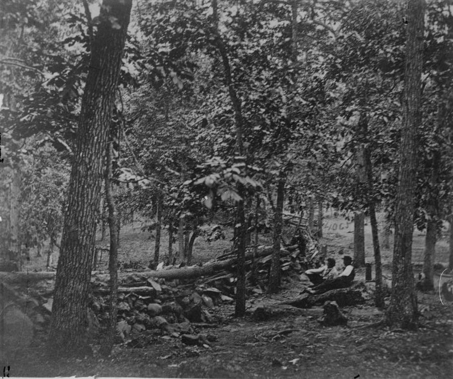
A view of these earthworks taken a couple of weeks after the battle. 145 years ago yesterday. Note the absence of undergrowth on the Confederate (east) side of the earthworks. This view was taken from the northwest facing southeast on approximately Wednesday, July 15, 1863.
The removal of growth ends on these otherworks on the far side of the tree. This view was taken from the northwest facing southeast at approximately 7:45 AM on Wednesday, July 16, 2008.
Here is one of the few recognizable paths on Culp’s Hill. This path leads to the monument to the 66th Ohio. This view was taken from the west facing east at approximately 7:45 AM on Wednesday, July 16, 2008.
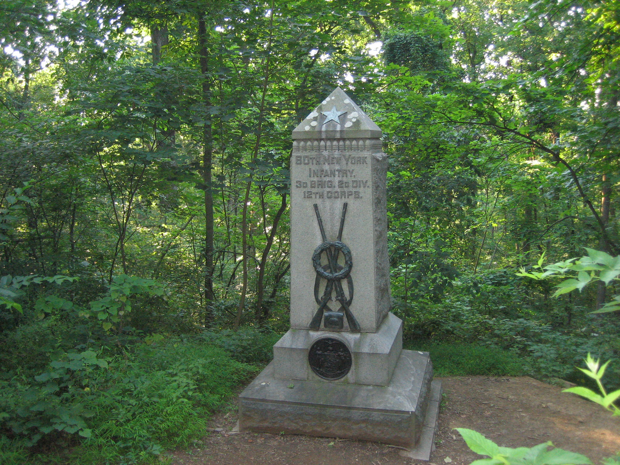
The monument to the 60th New York. The area around the monument is cleared so one can see the monument, but what did this unit see on the evening of July 2nd, and early morning of July 3rd as Confederates attempted to take their position? This view was taken from the west facing east at approximately 7:45 AM on Tuesday, July 8, 2008.
Ok, we take it back when we wrote that one can only see the Union lines. Please try to see the marker for the 6th Wisconsin of the Iron Brigade in this photograph. It’s there. The Iron Brigade constructed earthworks on Culp’s Hill before anyone else, and in the winter, one can see how they do their best to incorporate the military crest, and the rocks on the slope of the hill. But good luck now in attempting to see the position of one of the most famous units in the United States Army in July, 1863. This view was taken from the southeast facing northwest at approximately 7:45 AM on Wednesday, July 16, 2008.