Licensed Battlefield Guide Rich Kohr: Gettysburg’s Electric Trolley Part 4
February 2, 2009
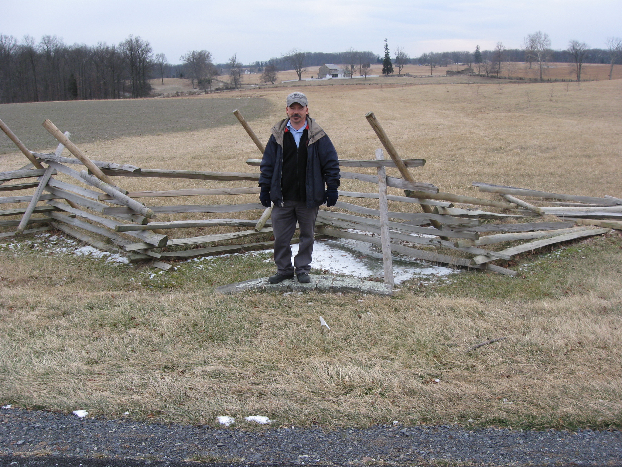
Licensed Battlefield Guide Rich Kohr is bringing the trolley south along the Emmitsburg Road towards the Peach Orchard. The red barn of the Alexander Spangler Farm is on the far left. The Joseph Sherfy Farm buildings are above Rich’s hand. The foundation to the Henry Wentz House is to the right of Rich’s hand. The Klingel Farm buildings are in the background to the right (east) of the Emmitsburg Road, and Cemetery Hill is in the background to the right of the Klingel buildings. This photograph is courtesy of the National Park Service. This view was taken facing north at approximately 2:00 PM on Sunday, January 18, 2009.
We are continuing our series on the Gettysburg Electric Trolley, which existed from 1893 to 1916. In our first trolley post, Gettysburg Licensed Battlefield Guide Rich Kohr took us from the Electric Power Station in the town of Gettysburg, over Cemetery Hill to Evergreen Cemetery. In our second post, Rich took the trolley out of Evergreen Cemetery, around the area of the “old” National Park Service Visitor Center, and showed how it was not allowed to continue along its proposed route on Cemetery Ridge. Our third post showed that because the trolley couldn’t travel on Cemetery Ridge, the “outbound” route needed to go to the Emmitsburg Road, where there were some other options, including double tracks at the Klingel Farm. Today’s post takes the trolley south along the Emmitsburg Road to where it turns on the Wheatfield Road at the Peach Orchard.
Licensed Battlefield Guide Rich Kohr: The Gettysburg Electric Trolley Part 1 on January 23, 2009.
Licensed Battlefield Guide Rich Kohr: The Gettysburg Electric Trolley Part 2 on January 26, 2009.
Licensed Battlefield Guide Rich Kohr: The Gettysburg Electric Trolley Part 3 on January 29, 2009.
This map shows the route of the trolley. The red line is the trolley route. The green line is the route of the Gettysburg/Harrisburg/Reading Railroad. For some time, the trolley used the Gettysburg/Harrisburg/Reading Railroad line from the Emmitsburg Road to Little Round Top to help establish a circular route on the battlefield. The blue sections are where the trolley had double or passing tracks. The white stars are the locations where we filmed videos, which we have numbered. Today’s post features videos #s 15-17. This map was created at approximately 9:30 PM on Monday, January 29, 2009.
In Video #15 (Videos 1-14 were featured on our first three trolley posts), Rich is standing at the northeast corner of the intersection of the Emmitsburg Road and the Wheatfield road, near Sherfy’s Peach Orchard. He explains how the trolley came south down the Emmitsburg Road and turned east on the Wheatfield Road. This view starts by facing north until we turn to the northwest, west, southwest, south, southeast, and eventually to the east at approximately 2:00 PM on Sunday, January 18, 2009.
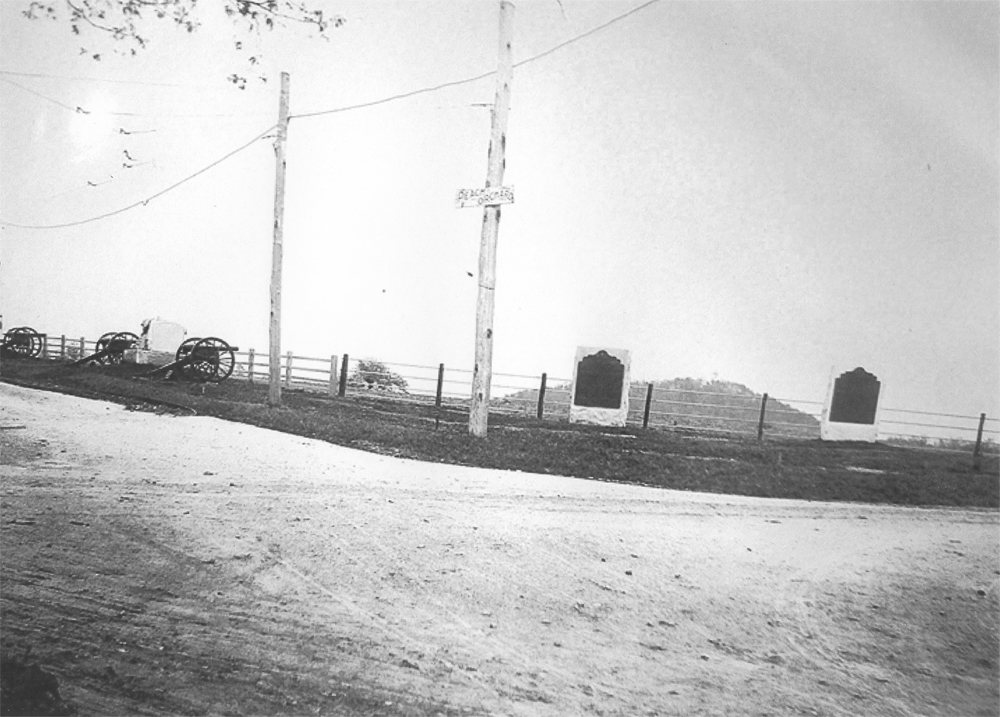
Here is the photograph that Rich showed us in Video #15. The monument to Battery F, 1st Pennsylvania Artillery (Hampton’s) was placed here between 1889 and 1893. Big Round Top and its tower (erected in 1895) are in the right background. The light colored monument to the the right (south) of the Wheatfield Road is to the 141st Pennsylvania Infantry Regiment. It was dedicated on September 12, 1889. This photograph is courtesy of the National Park Service. This view was taken facing southeast between 1895 and 1916.
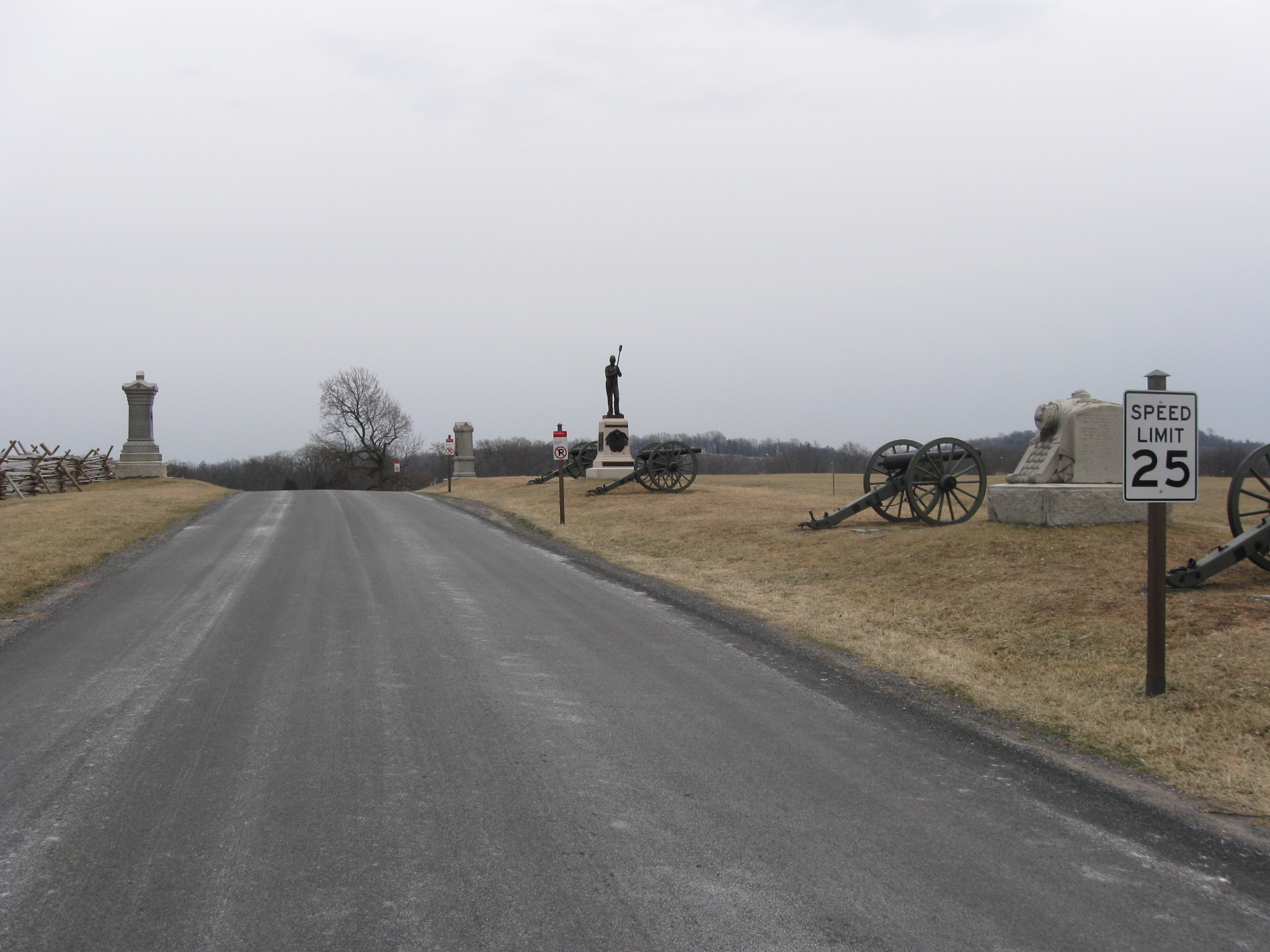
This photograph shows how the speed limit sign and the new “no parking” signs approximately the location of the trolley poles on the Wheatfield Road in the previous picture. The monuments visible in this picture from left to right are 68th Pennsylvania Infantry (dedicated July 2, 1888), the 141st Pennsylvania Infantry, Hampton’s Battery F, and Thompson’s Battery C, 1st Pennsylvania Artillery (placed here between 1886-1893). This view was taken facing east at approximately 2:00 PM on Sunday, January 18, 2009.
A view of the intersection of the Emmitsburg Road (right to left) and the Wheatfield/Millerstown Road (bottom right to middle left). Below the right (west) cannon of Thompson’s Battery C are the trolley tracks turning onto the Wheatfield Road. The U.S. Government markers at the Peach Orchard were erected between 1907 and 1912. Big Round Top and its tower are in the background. The sign for the Peach Orchard is on the closest trolley pole. This photograph is courtesy of Ben Dixon. This view was taken facing southeast between 1907 and 1916.
The Henry Wentz House and outbuildings are in the background. The trolley tracks turning from the Emmitsburg Road to the Wheatfield Road are barely visible in the foreground. This photograph is courtesy of the National Park Service. This view was taken facing northeast in 1909.
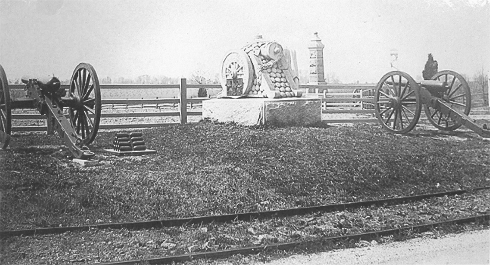
This photo shows the trolley tracks on the Wheatfield Road north of the Peach Orchard and Thompson’s Battery C, 1st Pennsylvania Artillery. The monument to Ames Battery G, 1st New York Artillery is the obelisk monument in the background. It was dedicated on July 3, 1893. The “Longstreet Tower” in the background on Seminary Ridge was erected in 1895. This photograph is courtesy of the National Park Service. This view was taken facing southwest between 1895 and 1916.
Rich is holding a photograph at the Wheatfield Road, which runs right to left or west to east, and Birney Avenue which is coming towards the camera. This view was taken facing south at approximately 2:00 PM on Sunday, January 18, 2009.
Here is the photograph Rich was showing in the previous image. The trolley tracks cross Birney Avenue at its intersection with the Wheatfield Road. Above Birney Avenue is the Rose Barn, which is no longer standing. The Rose House and outbuildings are in the left background. The piece of granite in the right foreground marks a culvert, and is still in this location. It can be seen in Video #16. This photograph is courtesy of the National Park Service. This view was taken facing south between 1893 and 1916.
Rich is standing on the trolley bed. The Wheatfield Road is on the right. The granite marker shown in the last photograph is hidden behind Rich. Birney Avenue is left to right. The monument to Hampton’s Battery F, 1st Pennsylvania Artillery is on the left of the Emmitsburg Road, and the monument to 68th Pennsylvania Infantry Regiment is to the right of the Emmitsburg Road. This view was taken facing west at approximately 2:00 PM on Sunday, January 18, 2009.
In Video #16, Rich explains how the trolley line came over the high ground at the Peach Orchard and continued on the south side of the Wheatfield Road through one of the most used parking spaces on the battlefield. This view was taken facing west to east at approximately 2:00 PM on Sunday, January 18, 2009.
We’re farther down the Wheatfield Road (we’ve moved east). Rich is standing near a culvert located north of and close to the Wheatfield Road and next to the monument of the 10th New York Artillery. Sickles Avenue is behind (west of) Rich. The top of the Sherfy Barn is in the background. This view was taken facing northwest at approximately 2:00 PM on Sunday, January 18, 2009.
In Video #17, Rich shows us how close the culvert is on the north side of the Wheatfield Road and how it was placed farther from the Wheatfield Road on the south side. This placement farther away from the road allowed the trolley to be located south of the Wheatfield Road. Rich also shows us how the trolley tracks will turn from the Wheatfield Road towards Rose’s Woods and eventually the Wheatfield. This view was taken facing northwest to a couple of other directions at approximately 2:00 PM on Sunday, January 18, 2009.
Rich is standing on the culvert on the south side of the Wheatfield Road. It allows enough space here for the trolley bed. The Rose House is in the background above Rich. The ruins of the Rose Farm are in the right background. This view was taken facing south at approximately 2:00 PM on Sunday, January 18, 2009.
See our previous posts on Gettysburg Licensed Battlefield Guides:
Gettysburg Guide Room: The Final Days on March 8, 2008.
Lights Out at the Electric Map on April 13, 2008.
New Guide Room at the New Visitor Center on April 19, 2008.
New Association of Licensed Battlefield Guide Office and Library Opens on August 25, 2008.
Evergreen Cemetery Headstone Damage with LBG Deb Novotny on October 20, 2008.
Camp Letterman Part 1 with LBG Phil Lechak on November 15, 2008.
Camp Letterman Part 2 with LBG Phil Lechak on November 17, 2008.
Gettysburg Artillery Part 1 with LBG George Newton on November 21, 2008.
“Mammy’s Little Baby Loves Guided Tours” with LBG Charlie Fennell on November 23, 2008.
Bucktails on McPherson’s Ridge Part 1 with LBG Rich Kohr on November 26, 2008.
Gettysburg Licensed Battlefield Guide Exam 2008 on December 6, 2008.
Gettysburg Hawk Hunting with Licensed Battlefield Guide Dave Weaver on December 14, 2008.
Licensed Battlefield Guide Rich Bellamy: Colonel Edward Ephraim Cross Part 1 on January 3, 2008.
Licensed Battlefield Guide Rich Bellamy: Colonel Edward Ephraim Cross Part 2 on January 5, 2009.
Licensed Battlefield Guide Rich Kohr: William Wible’s Gettysburg Quarry on January 21, 2009.
Licensed Battlefield Guide Rich Kohr: The Gettysburg Electric Trolley Part 1 on January 23, 2009.
Licensed Battlefield Guide Rich Kohr: The Gettysburg Electric Trolley Part 2 on January 26, 2009.
Licensed Battlefield Guide Rich Kohr: The Gettysburg Electric Trolley Part 3 on January 29, 2009.