

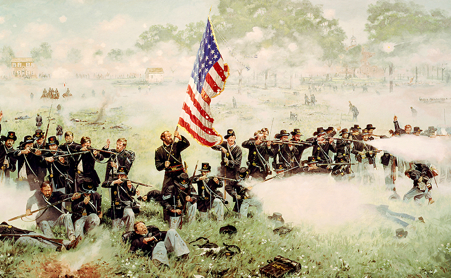
Colonel Henry Morrow and the Iron Brigade’s 24th Michigan Infantry Regiment fight a desperate delaying action on Seminary Ridge on the afternoon of July 1, 1863. With all the color bearers and color guard down, Colonel Morrow took the flag to rally his command. The Charles Krauth House is in the left background. The Seminary’s dormitory and classroom building, now known as Schmucker Hall is in the right background. This image, titled “Men of Iron” by artist Dale Gallon is courtesy of Ms. Anne Gallon of Gallon Historical Art Inc., 9 Steinwehr Avenue, Gettysburg, PA 17325. Their telephone number is 717-334-8666. Their e-mail address is [email protected]. Their web address is gallon.com.
In today’s Iron Brigade post, Gettysburg Licensed Battlefield Guide Richard Goedkoop shows the locations where the Iron Brigade made their stand on Seminary Ridge on the afternoon of July 1, 1863.
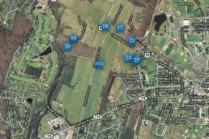
This map shows the location of the videos for Iron Brigade posts. Videos #1-#22 were shown in our previous Iron Brigade posts. Video #17 was taken at the Railroad Cut Video #18 was taken on east McPherson’s Ridge. Video #19 was taken by the monument to the 7th Wisconsin Regiment. Video #20 was taken by the monument to the 26th North Carolina Infantry Regiment. Videos #21 and #22 were taken on East McPherson’s Ridge near the junction of Reynolds Avenue and Meredith Avenue. Video #23 was taken at the Stewart Battery Marker on Seminary Ridge, north of the Chambersburg Pike. Video #24 was taken in the field in front of the position of Stevens’ Maine Battery. Video #25 was taken on the summit of Seminary Ridge at the position of Stevens’ Maine Battery. This map was created facing north at approximately 7:00 PM on Thursday, December 2, 2010.

Gettysburg Licensed Battlefield Guide Rich Goedkoop is the host for the Iron Brigade series. He is standing by the marker for Battery B, 4th United States Artillery, commanded by Lieutenant James Stewart. The 6th Wisconsin of the Iron Brigade provided the infantry support for Stewart’s battery. The white structures in the background are at Larson’s Quality Inn. This view was taken facing northeast at approximately 5:45 PM on Saturday, July 17, 2010.
In Video #23 (Videos #s 1-22 were shown in our previous Iron Brigade posts) Gettysburg Licensed Battlefield Guide Rich Goedkoop is standing on Seminary Ridge near the marker to Stewart’s U.S. battery. He shows positions of some of the Union artillery on Seminary Ridge, and how they fired at the Confederate brigades commanded by Alfred Scales and Abner Perrin. This view was taken facing northeast to northwest to south to southwest to south at approximately 5:45 PM on Saturday, July 17, 2010.
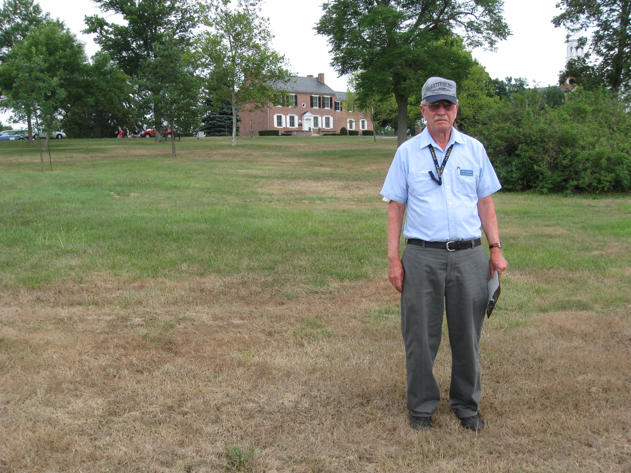
Licensed Battlefield Guide Richard Goedkoop is standing on the west slope of Seminary Ridge. The Charles Krauth House, constructed in 1834, is in the background. The position of Stevens’ Maine Battery is in the background to the left (northwest) of the house. This view was taken facing southeast at approximately 5:45 PM on Saturday, July 17, 2010.
In Video #24 Licensed Battlefield Guide Rich Goedkoop is standing on the east slope of Seminary Ridge. He describes how the Iron Brigade fell back to Seminary Ridge. This view was taken facing southeast at approximately 5:45 PM on Saturday, July 17, 2010.
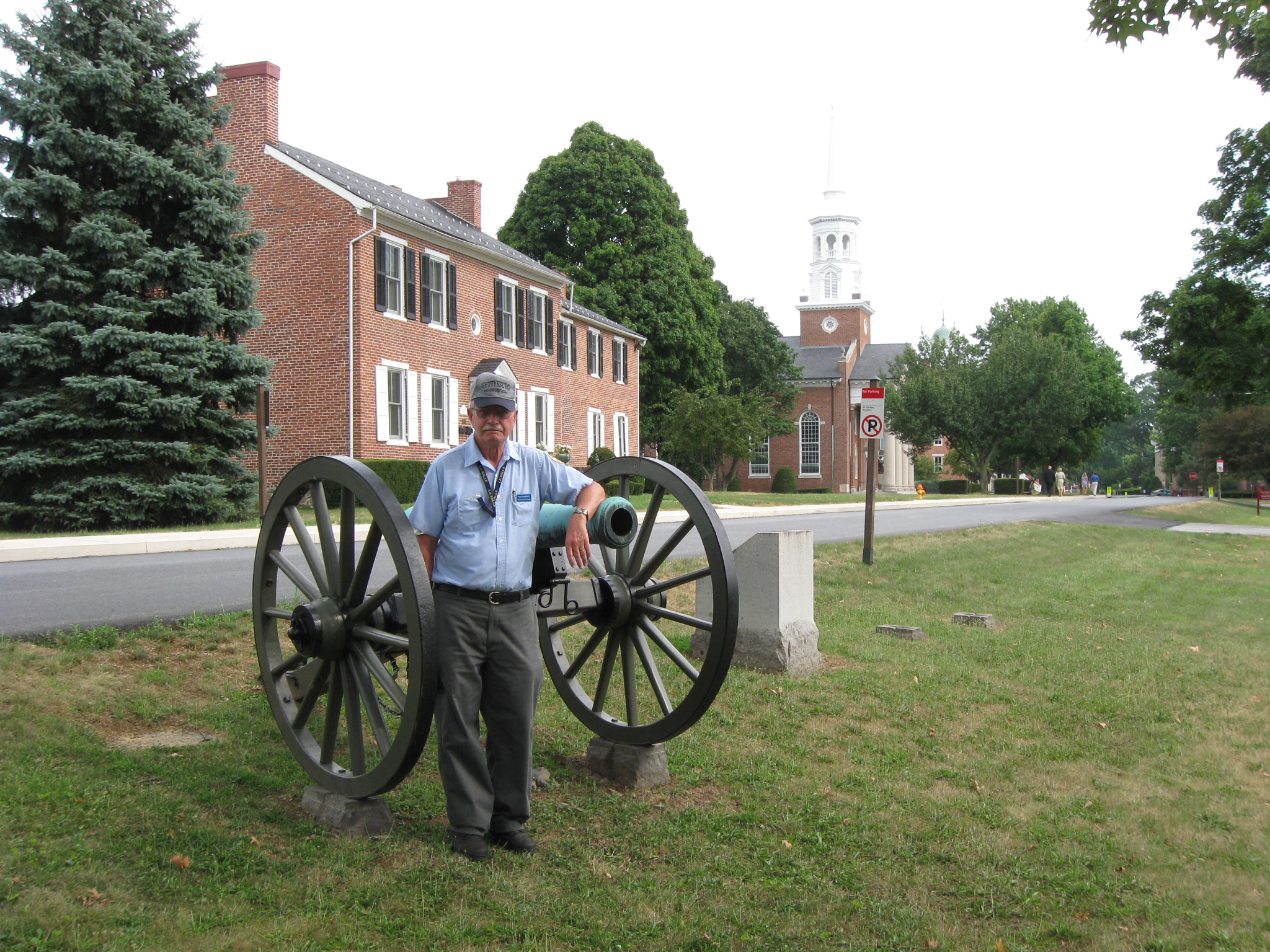
Dr. Richard Goedkoop is standing on Seminary Ridge near Seminary Avenue and the cannon and marker for Captain Greenleaf Stevens’ Battery E, 5th Maine Artillery. The Charles Krauth House is in the background directly behind Dr. Goedkoop. The 1942 Seminary Chapel (with the white steeple) is to the right of the Krauth House. To the right of the columns of the 1942 Seminary Chapel are the red bricks to the Seminary’s main building in 1863, now known as Schmucker Hall. In fact the green top of the cupola is barely visible above the trees. This view was taken facing southeast at approximately 5:45 PM on Saturday, July 17, 2010.
In Video #25 Licensed Battlefield Guide Rich Goedkoop is standing on Seminary Ridge near the position of Stevens’ Maine Battery. He describes how the Iron Brigade left Seminary Ridge through the town, and eventually to Cemetery Hill and Culp’s Hill. This view was taken facing southeast at approximately 5:45 PM on Saturday, July 17, 2010.
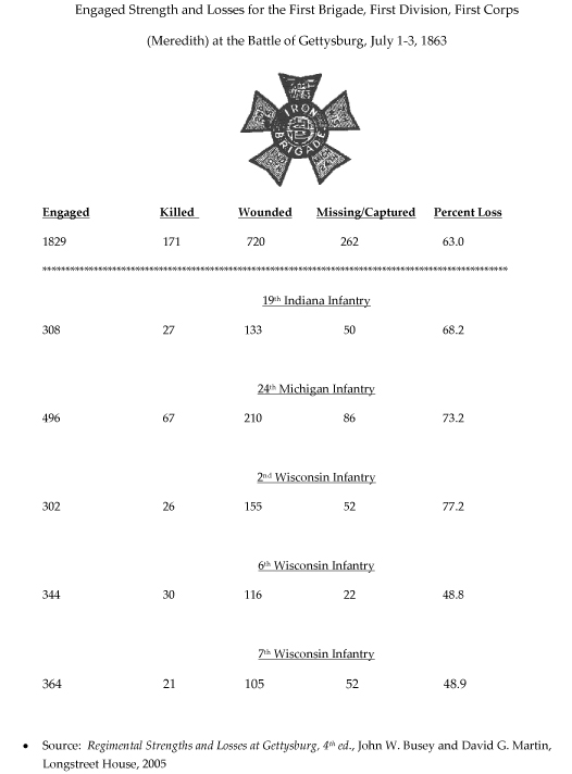
Some statistics from the Iron Brigade’s action at Gettysburg.