

Mathew Brady’s photograph of Union fortifications on Culp’s Hill. A couple of trees in this photograph are still standing as we have shown on our post of December 5, 2008. This photograph was taken facing south circa July 15, 1863.
Our Culp’s Hill series is lead by Gettysburg Licensed Battlefield Guide Dr. Charles Fennell. Dr. Fennell received his Ph.D. in history from West Virginia University in 1992. His dissertation was titled, “The Battle of Culp’s Hill.” In our first post on Culp’s Hill, he began our tour at the summit, near the observation tower. In our second post he continued his walk around Culp’s Hill by discussing the position of the 60th New York Infantry Regiment. In today’s post he looks at the earthworks in the area of the monuments to the 150th New York Infantry Regiment and the 78th and 102nd New York Infantry Regiments.
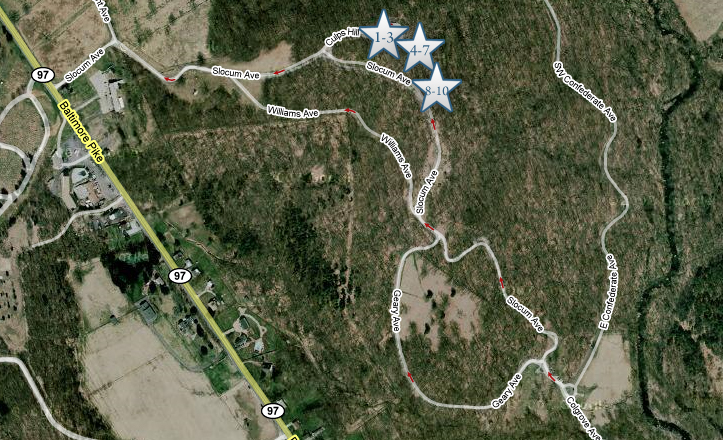
This map will show the locations of the videos we will show on the tour. Videos #1-#3 were taken on the summit of Culp’s Hill near the observation tower. Videos #4-#7 were taken near the monument to the 60th New York Infantry Regiment. Videos #8-#10 were taken between the monuments to the 150th New York and the 78th/102nd New York Infantry Regiments. This map was created facing north at approximately 6:00 PM on Friday, April 17, 2009.

Dr. Charles Fennell is standing at the location where the Mathew Brady photograph at the beginning of this post was taken on July 15, 1863. The monument to the 150th New York Infantry Regiment is behind the camera. This view was taken facing south at approximately 9:45 AM on Sunday, March 22, 2009.
In Video #8 (Videos 1-7 were shown in the previous posts on Culp’s Hill), Charlie Fennell explains where the earthworks were located, how they were dismantled, how the Civilian Conservation Corps reconstructed them, and how they are located on the military crest. This view was taken facing north to northeast to east at approximately 9:45 AM on Sunday, March 22, 2009.

Charlie Fennel is standing by the monument to the 78th and 102nd New York Infantry regiments. In the left background is the monument to the 28th Pennsylvania Infantry Regiment. The Culp’s Hill observation tower can be seen through the trees at the summit of Culp’s Hill. The tall monument to the 150th New York Infantry Regiment is in the right background. This view was taken facing north at approximately 9:45 AM on Sunday, March 22, 2009.
In video #9, Charlie points out the lion on the monument to the 78th and 102nd New York Infantry regiments, and discusses the intensity of the Confederate attacks in this area the evening of July 2, 1863. This view was taken facing north to northeast to east at approximately 9:45 AM on Sunday, March 22, 2009.

A closeup of the lion on the monument to the 78th and 102nd New York Infantry regiments. This view was taken facing north at approximately 9:45 AM on Sunday, March 22, 2009.

The best defined set of earthworks in the Culp’s Hill area. Here one can see how the earthworks form a salient in this area between the monument to the 78th and 102nd New York Infantry regiments and the 149th New York Infantry Regiment. The cameraman is standing on the earthworks which run southeast towards Charlie. Charlie is standing at the point or angle or salient of the earthworks. The earthworks then run towards Charlie’s back right or south. Lower Culp’s Hill or Spangler’s Hill is visible through the trees in the background. The Confederates attacked uphill from left to right (east to west) in this view. This view was taken facing southeast at approximately 9:45 AM on Sunday, March 22, 2009.
In video #10, Licensed Battlefield Guide Charlie Fennell explains how Brigadier-General George Sears Greene used his military engineering expertise to build earthworks that would create interlocking fields of fire. This view was taken facing southeast to east at approximately 9:45 AM on Sunday, March 22, 2009.
To see other posts by Gettysburg Licensed Battlefield Guides, click here.