Gettysburg Daily

140 Places Every Guide Should Know Part 2: Gettysburg LBG Fred Hawthorne

Gettysburg Licensed Battlefield Guide Fred Hawthorne is the author for our 140 Places Every Guide Should Know series. He is on Cemetery Ridge outside the “inner angle” of the stone wall in the High Water Mark area. This view was taken facing east at approximately 5:15 PM on Friday, September 17, 2010.

Fred Hawthorne’s interest in the American Civil War stemmed from stories his grandmother related of his soldier-ancestors’ war experiences. Such stories spurred him at an early age to read every book and magazine he could find dealing with the war and his family’s role in it. Hawthorne’s ancestors took up arms on both sides of the Mason-Dixon Line. Fred’s distant cousin, Lieutenant Thomas Huddleston, was the first western Virginia Confederate officer to die in the war – accidentally shot by one of his own men while guarding a bridge in the spring of 1861. Fred’s great grand-uncle Alex Armstrong served as a sharpshooter in Company B of the 100th Pennsylvania Infantry. The 100th took part in most of the campaigns of Ambrose Burnside’s 9th Army Corps. Another great grand-uncle in the same unit had the fingers of his hand shot off in the initial assaults on Petersburg in June of 1864. His great, great-grandfather rode with the 8th Virginia Cavalry and was captured by the Yankees while foraging for horses that same year. The study of that crucial period of American history became a lifelong interest.

Fred served four years as an Intelligence Analyst with the United States Air Force during the later stages of the Vietnam War. Assignment to the National Security Agency in Washington, D.C. for much of this period allowed for many off-duty hours stomping, studying and relic-hunting the old battlefields of northern and central Virginia. Following completion of his service obligation Fred earned a university degree in American History and another in Secondary Education at the Pennsylvania State University. He went on to acquire an advanced degree in Colonial American History and Historical Archaeology. He spent sixteen years teaching history and economics on both university and secondary school levels before making a career change to educational computing in the early 1990’s operating a 400-station computer network for a public school district in south central Pennsylvania.

Following graduation from Penn State Fred settled in Gettysburg, Pennsylvania in a house built on ground over which Lee’s troops passed in their final assault on the Union center. The first day he lived in the house was marked with finding a dropped Confederate bullet while planting shrubbery. This location has given the opportunity of spending countless hours walking the more than twenty-five square miles of that historic site.

In 1981 Fred took the battlefield guide qualifying exam administered by the National Park Service earning a federal license to serve as a Licensed Battlefield Guide. For the past twenty-nine years he has conducted more than 50,000 visitors around the battlefields of Gettysburg and other sites of that war. These visitors came from all fifty states and over forty foreign countries. For thirteen of those years Fred served as president of the Association of Licensed Battlefield Guides, Inc. – the oldest professional guide service in the United States dating back to 1915. He still holds several executive positions with that organization.

He is also the author of the book, Gettysburg: Stories of Men and Monuments As Told By Battlefield Guides.

To contact Fred, please click here to reveal his email address.

In our first 140 Places Every Guide Should Know post Gettysburg Licensed Battlefield Guide Fred Hawthorne introduced the series and showed us the Gettysburg Legislation Plaque/Marker, and the locations where three African American families lived on the battlefield at the time of the Gettysburg Campaign.

In today’s 140 Places Every Guide Should Know post Gettysburg Licensed Battlefield Guide Fred Hawthorne shows us the marker for John Page Nicholson, Meade Avenue, and the Stockton Rock outside of the “inner angle” of the stone wall.

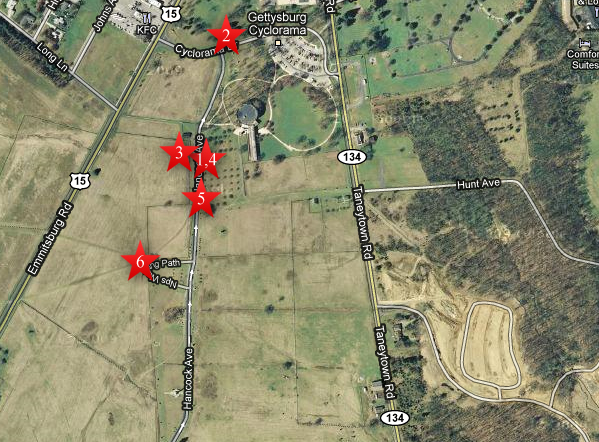
This map shows us the locations taken of the videos for the 140 Places Every Guide Should Know series. Videos #1 and #4 were taken at the John Page Nicholson marker. Video #2 was taken at the Gettysburg National Military Park Legislation Plaque/Marker. Video #3 was taken on the Abraham Bryan Farm. Video #5 was taken at the location of Meade Avenue. Video #6 was taken at the Stockton Rock. This map was created facing north at approximately 5:15 PM on Tuesday, October 5, 2010.

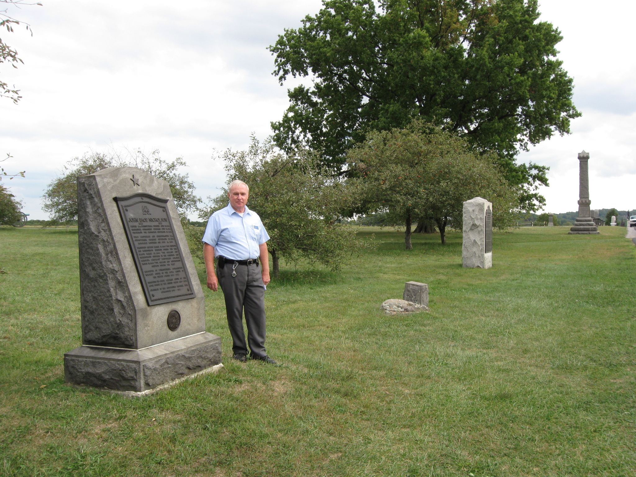
Gettysburg Licensed Battlefield Guide Fred Hawthorne is standing on Cemetery Ridge near the marker to John Page Nicholson. The tall monument in the right background is to the 39th New York Infantry Regiment, the Garibaldi Guards. This view was taken facing southeast at approximately 5:15 PM on Friday, September 17, 2010.
In Video #4 (Videos #1-#3 were shown in our previous 140 Places post) Gettysburg Licensed Battlefield Guide Fred Hawthorne is standing on Cemetery Ridge near the marker for John Page Nicholson. Fred explains why Nicholson was an important individual behind the early development of Gettysburg National Military Park. This view was taken facing northeast to east to northeast at approximately 5:15 PM on Friday, September 17, 2010.

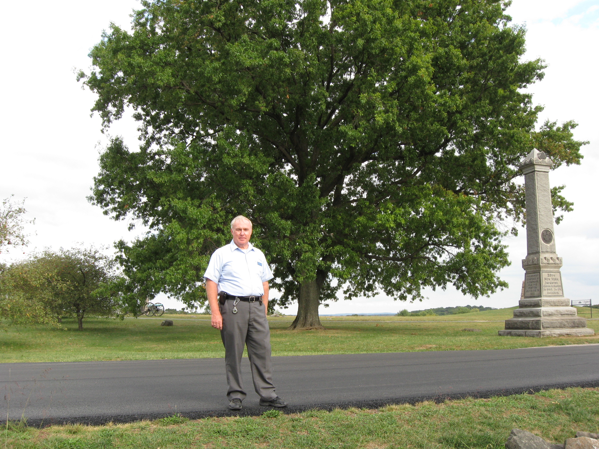
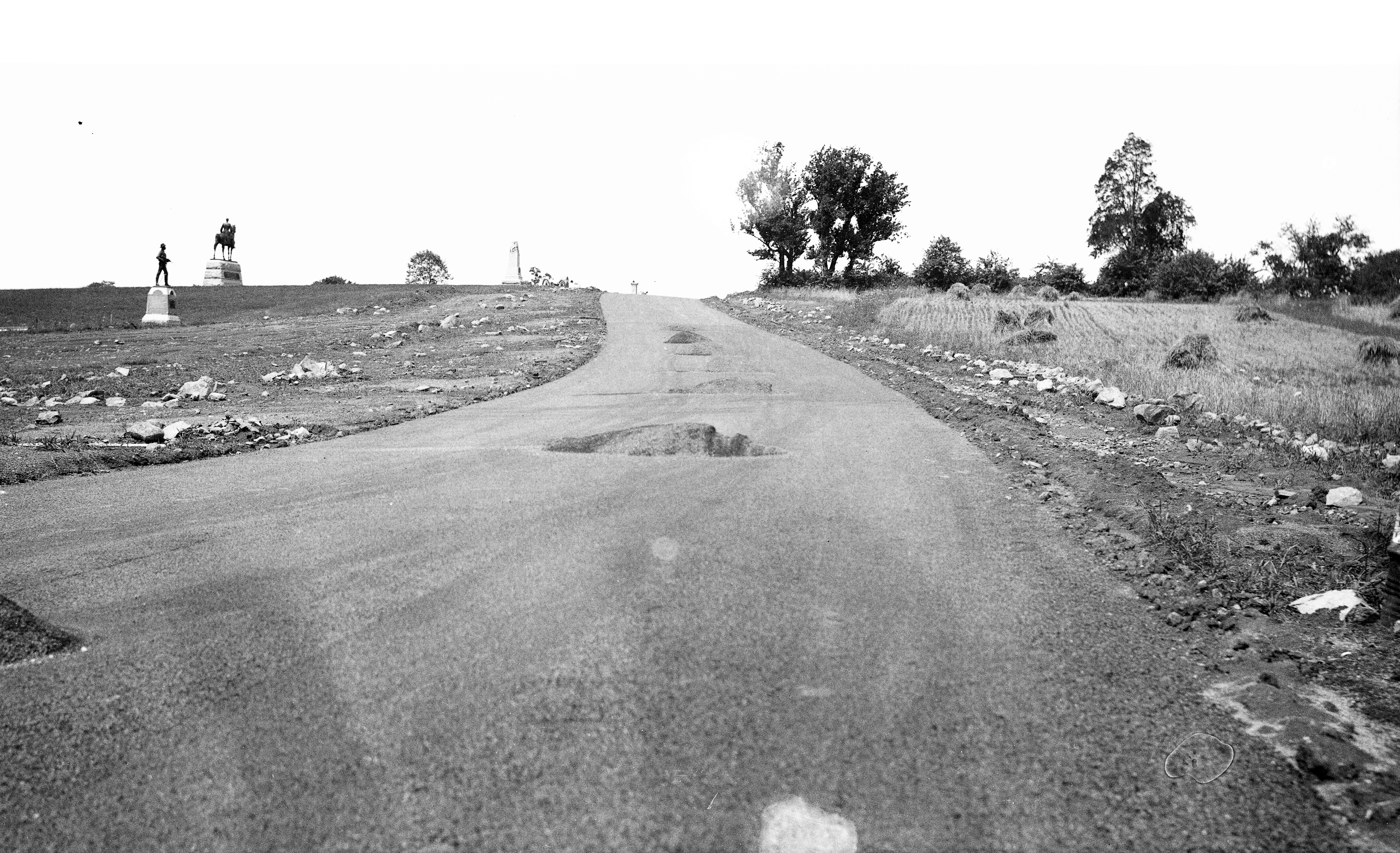
Licensed Battlefield Guide Fred Hawthorne is standing on Cemetery Ridge’s Hancock Avenue near the location of Meade Avenue, which used to make a junction with Hancock Avenue behind Fred. The monument on the right is to the 39th New York Infantry Regiment. Out of sight, behind the monument, is the equestrian statue to Major General George Gordon Meade. This view was taken facing southeast at approximately 5:15 PM on Friday, September 17, 2010.
In Video #5 Licensed Battlefield Guide Fred Hawthorne shows us the location of Meade Avenue. This view was taken facing southeast to northeast to east at approximately 5:15 PM on Friday, September 17, 2010.

Meade Avenue connected the Taneytown Road (in the foreground from right to left) with Hancock Avenue on the top of Cemetery Ridge. The Lydia Leister House and Barn (Meade’s Headquarters) are on the left. This view, courtesy of Fred Hawthorne, was taken facing west.

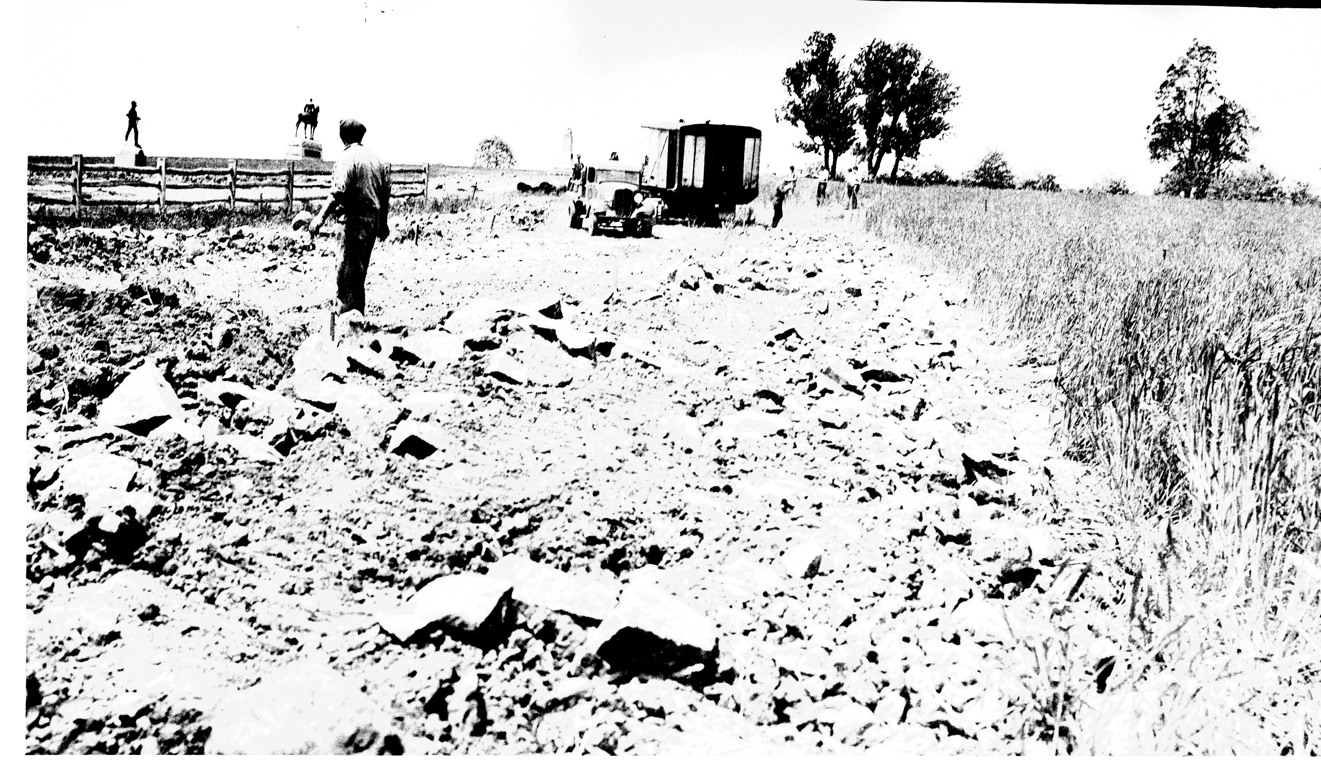
The next two photographs show the Civilian Conservation Corps relocating Meade Avenue. The monument to the 2nd Pennsylvania Cavalry Regiment, and the Meade equestrian statue are in the left background. Before… This view, courtesy of The Center for Civil War Photography, which has more than 1,000 historic Gettysburg Park images like these on their Flickr, was taken facing west circa 1937.

…and after. This view, courtesy of The Center for Civil War Photography, which has more than 1,000 historic Gettysburg Park images like these on their Flickr, was taken facing west circa 1937.

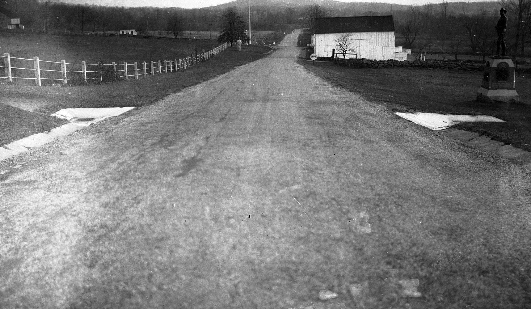
Meade Avenue, looking down the east slope of Cemetery Ridge. The monument to the 2nd Pennsylvania Cavalry Regiment is on the right, as is the Leister Barn. Notice the sign warning visitors to “Slow” before they not only get to the Leister House, but the Taneytown Road, where they would have to stop. The avenue continuing on the other “east” side of the Taneytown Road is Hunt Avenue. This view, courtesy of The Center for Civil War Photography, which has more than 1,000 historic Gettysburg Park images like these on their Flickr, was taken facing east at some unknown time.

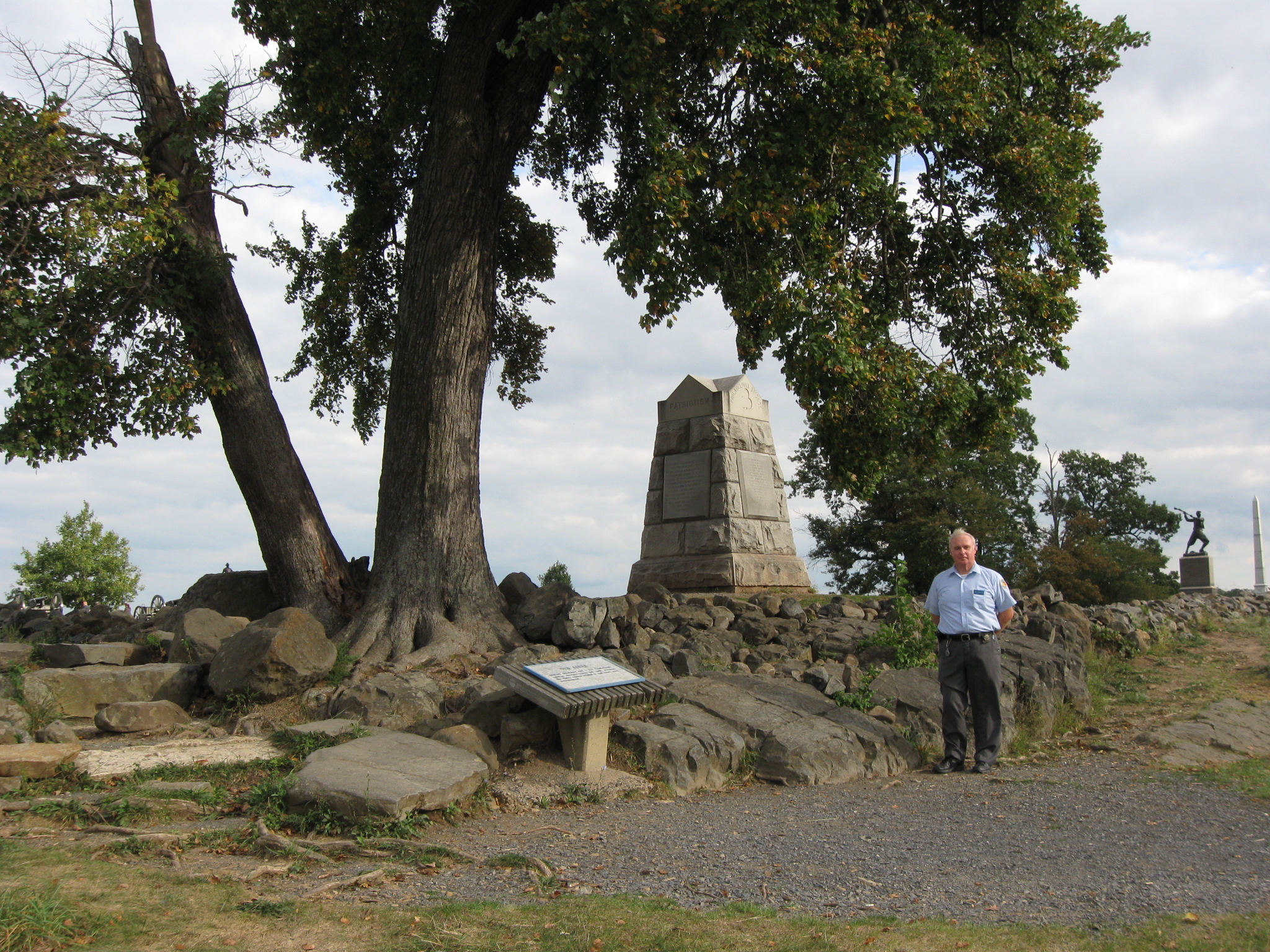
Fred Hawthorne is standing on the west slope of Cemetery Ridge near the Stockton Rock. The Stockton Rock is the large rock directly below the monument to the 71st Pennsylvania Infantry Regiment. It is between Fred and the wayside describing the Angle. This view was taken facing southeast at approximately 5:15 PM on Friday, September 17, 2010.
In Video #6 Fred Hawthorne is standing outside the “inner angle” of the stone wall, near the Stockton Rock. He describes how Sergeant Major William Stockton and some other men from the 71st Pennsylvania Infantry Regiment, were held on the rocks in this area as prisoners during “Pickett’s Charge” on July 3, 1863. This view was taken facing east to southwest at approximately 5:15 PM on Friday, September 17, 2010.

140 Places Every Guide Should Know

The following list, certainly not a difinitive one, was compiled by several Guides during long rides back and forth to grad school. It is in no way the “official policy” of the N.P.S. or the A.L.B.G., nor is it necessarily all knowledge expected of prospective new Guides. It is felt that in addition to a good, overall knowledge of the battle, a firm knowledge of the various features and sites related to the area and its pre and post battle history is necessary information for a newly-licensed Guide to begin to acquire.

As of now, there are 145 places/facts on the list, and they are not in any particular order.

1. Timbers’ Farm
2. “The Devil’s Kitchen”
3. “Slaughter Pen”
4. The actual “Devil’s Den”
5. Neill Avenue
6. Hampton Battery Rock
7. Fuller Marker
8. Irsch Advance Marker
9. Jones Artillery Avenue
10. 1st Shot Marker
11. Hazlett Inscription
12. McAllister Mill Site
13. Menchey’s Spring
14. Wagon Hotel
15. Coster Avenue
16. “Trough” Rock
17. Forney Farm Site
18. Fahnestock Building
19. Henry Culp House
20. Dan Shaffer Farm
21. George House
22. South Cavalry Field
23. 1st Corps Barricade site
24. Bushman Hill
25. Herbst Woods
26. Ohio Flank Markers on Cemetery Hill
27. Ginny Wade’s Three “Houses”
28. 25th Anniversary Memorial
29. 50th Anniversary Memorial
30. Warfield Ridge
31. Warfield House
32. Hunt’s HQ Marker
33. Tipton Inscription
34. John Burn’s House site
35. George Nixon’s Grave
36. Bigelow’s “Gate”
37. Brown’s “Gate”
38. Dinosaur Footprints
39. Springs Hotel Site
40. “A.L. Coble” Rock
41. “D.A.” Rock
42. Greene’s Traverse
43. Palmer Marker
44. Heth Wounding Tree
45. Gibbon Tree
46. 54th NY Skirmish Line
47. Iron Brigade Position, Culp’s Hill
48. Vincent Inscription
49. 40th NY Inscription
50. Original “Valley of Death”
51. Parrott Rifle #1 (CP)
52. Belmont Schoolhouse
53. Rock on which Ellis’ and Cromwell’s bodies were placed following death.
54. McPherson’s Woods
55. 32nd Mass Aide Station
56. Site where Colonel Avery fell
57. Ginny Wade’s three graves
58. Armistead’s Grave site
59. Heagy Farm site
60. Alms House site
61. Old Adams Co. Prison
62. Sickles’ Wounding Site
63. J. Weikert Farm
64. Granite Schoolhouse Site
65. Stock House
66. Sweeney House
67. Schimmelfennig’s Shed site
68. Howe Avenue
69. Eagle Hotel site
70. Chaplain Howell Shot marker
71. Williams Avenue
72. Power’s Hill
73. Ordnance Rifle #233
74. Berdan Avenue
75. Triangular Field
76. Pardee Field
77. Sachs’ Bridge
78. Emanuel Pitzer Farm
79. George Sandoe’s Death site
80. Penelope Ann
81. Only ’63 Tree left in the National Cemetery
82. Location of the only 6 Rifled Napoleons made.
83. Houck’s Ridge
84. Advanced Marker 1st Md CSA
85. Ewell’s HQ Marker
86. Newton’s HQ Marker
87. Confederates in Natl. Cem
88. Lt. Col. Fowler Killed
89. Seminary Buildings ’63
90. College Buildings ’63
91. Wentz House
92. Rogers House Site
93. George Sandoe’s Grave
94. Raffensberger’s Hill
95. “The Killing Swale”
96. Spangler’s Meadow
97. Capture site 150th Pa Flag
98. Chamberlain Avenue site
99. Meade Avenue site
100. Devil’s Slipper
101. Commonwealth of PA Parrotts
102. State of Connecticut James Rifles
103. Only statue of regimental commander on the field
104. Semmes’ Wounding site
105. “CORA”
106. Codori Spring
107. Location of only original 6 Pdr on field
108. “Brockenbrough’s” Rock Quarry
109. 5th Ohio’s Skirmish Line “HQ”
110. “P. Noel” carving
111. McGilvery Avenue
112. Red Patch
113. Herman Haupt’s Gettysburg Home
114. Josiah Benner’s Springhouse
115. Col. Collis’s grave
116. “Sickles’ Act” plaque
117. John Page Nicholson marker
118. William Miller’s Grave
119. Where Amos Hummiston died
120. 123rd NY Skirmish Marker
121. Slocum’s HQ marker
122. Sgt. Major Stockton’s rock
123. Western Maryland Railroad Station
124. Vincent wounding inscription.
125. “Second” Spangler’s Spring
126. Z. Taney Farm site.
127. Army of Potomac Right Flank Marker
128. Christ Lutheran Church
129. German Reformed Church
130. Wesley Culp’s Grave
131. Burial plot of museum remains.
132. 26th Pa. Emergency “Action” Marker
133. Blocher’s Knoll
134. “The Big Rocks”
135. Battle Dead plot in Evergreen
136. Exact location of speaker’s platform on November 19.
137. Twelve buildings that still have Civil War artillery shells in them.
138. Site of the original advance marker of the 27th Connecticut.
139. Pump site where Gen. Early wrote demands on Gettysburg, June 26.
140. Oldest existing Gettysburg church still used as a church.
141. Gen. Crawford’s HQ site night of July 2.
142. Homes of three free Black families on field at time of the battle.
143. What was first monument on the field with a clearly visible Confederate Flag on it?
144. Last Civil War/Gettysburg veteran to serve as park superintendent
145. Willard’s Death Site

Fred Hawthorne is the author of the book, Gettysburg: Stories of Men and Monuments As Told By Battlefield Guides. It was published by the Association of Licensed Battlefield Guides in 1988, and is available in many Gettysburg area bookstores. This image was scanned facing south at approximately 9:00 PM on Friday, September 17, 2010.