
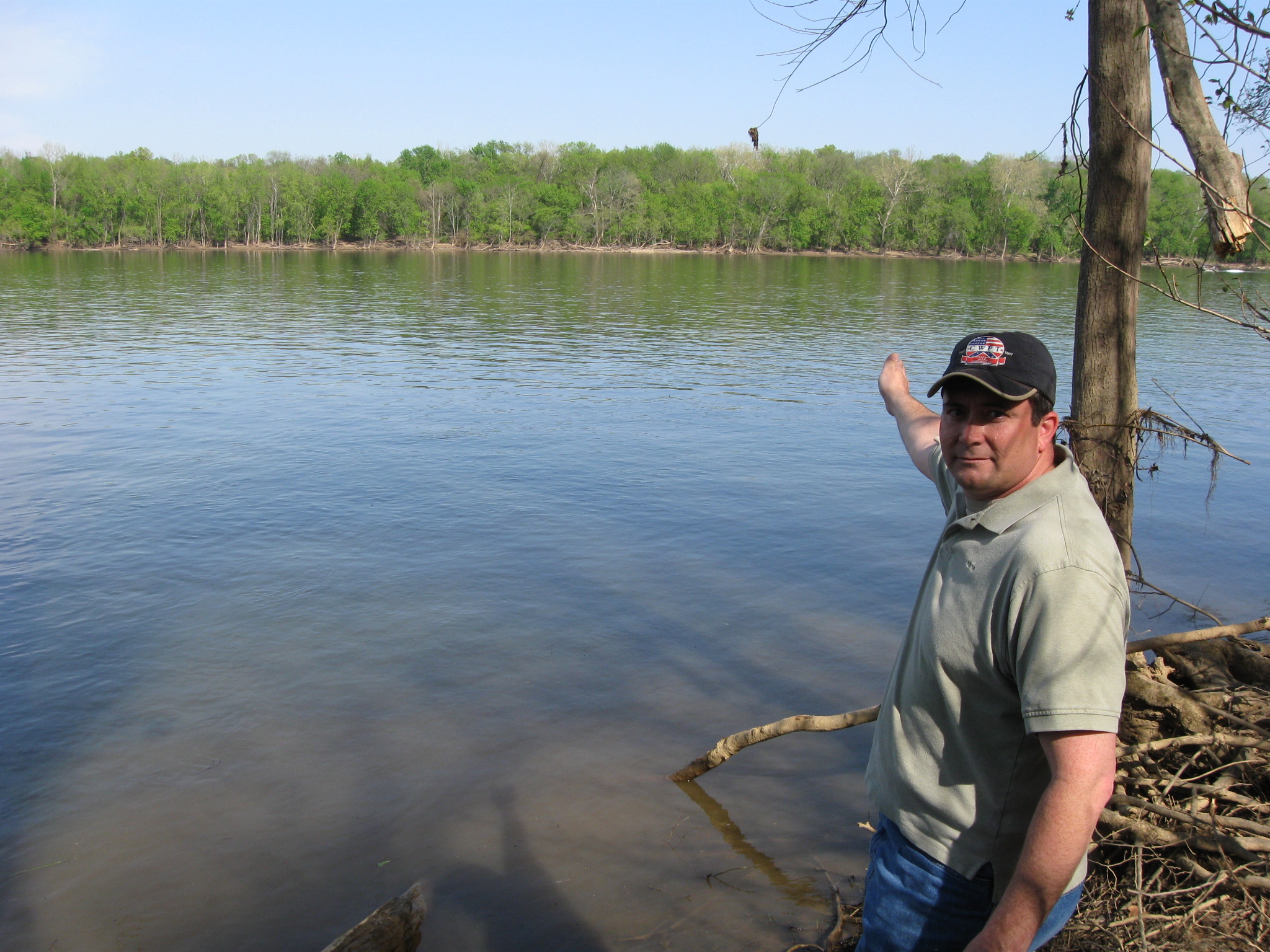
Craig Swain is a native of Missouri who now lives in Northern Virginia. He is standing on the Virginia side of the Potomac River and is pointing out the location where he believes the second pontoon bridge was constructed at Edwards Ferry in June, 1863. This view was taken facing east at approximately 4:00 PM on Sunday, April 11, 2010.
The United States’ Army of the Potomac crossed the Potomac River near Leesburg, Virginia, from June 25-27, 1863. Historian Craig Swain describes this movement of men, animals, equipment and supplies, from Virginia to Maryland during the Gettysburg Campaign.
In today’s Edwards Ferry post, Historian Craig Swain shows us the area where the second bridge was constructed, presents a timeline of when units of the Army of the Potomac crossed the bridges.

This map shows the location of the Edwards Ferry Videos. Video #s 1-3 were shown in our first Edwards Ferry post. Videos #4-5 were taken along Goose Creek near the site of Kephart’s Mill. Video #6 was taken near one of the canal locks of the Goose Creek canal. Videos #7-#12 were taken along the Virginia side of the Potomac River near the mouth of Goose Creek. This map was created facing north at approximately 4:30 PM on Tuesday, May 4, 2010.

This map shows some of the important locations along Goose Creek including the Goose Creek Canal, the locks of the canal, and the California Road crossing Goose Creek. The red X shows that the bridge had been destroyed earlier in the war, so was not available in 1863. In yellow are the pontoon bridges of the Army of the Potomac constructed in June, 1863. One bridge crosses Goose Creek (Craig showed where he believes its location was in our last picture on this post), the two pontoon bridges crossing the Potomac River at Edwards Ferry, and the bridges crossing the Chesapeake and Ohio Canal on the east (Maryland) side of the Potomac River. In today’s post, Craig shows us where he believes the second bridge was constructed. The map was provided by Craig Swain.
In Video #10 (Videos #1-#9 were shown in our previous Edwards Ferry posts) Craig Swain is standing on the Virginia side of the Potomac River near the mouth of Goose Creek. He shows the location of the second pontoon bridge constructed across the Potomac River by soldiers in the Engineer Brigade of the Army of the Potomac. This view was taken facing east at approximately 4:00 PM on Sunday, April 11, 2010.

Craig Swain is on the Virginia side of the Potomac River and Goose Creek is behind him. He is showing a timeline that he created of when and on what bridge the Army of the Potomac crossed at Edwards Ferry. In theory, it could have taken the Army of the Potomac one day to cross the river. In reality, it took three days. This view was taken facing north at approximately 4:00 PM on Sunday, April 11, 2010.
In Video #11, Craig Swain shows us the timeline that he created for the crossing of the Potomac River at Edwards Ferry by the Army of the Potomac. This view was taken facing north to northeast at approximately 4:00 PM on Sunday, April 11, 2010.
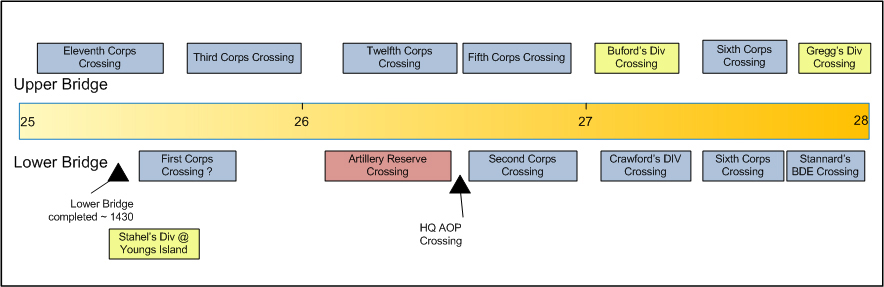
Historian Craig Swain’s timeline. This image was provided by Craig Swain.
At Edwards Ferry, the Army of the Potomac crossed between 75,000 to 80,000 infantrymen, and approximately 12,000 cavalrymen. 369 artillery pieces also utilized the bridges along with 3000 supply wagons. The length of the column exceeded 80 miles. This view was taken facing east at approximately 4:00 PM on Sunday, April 11, 2010.
In Video #12, Craig Swain explains what units crossed the bridges on what days. He explains that the crossing began on June 25th, was finished by June 28th, and the bridge was packed up and removed on June 29th. This view was taken facing east at approximately 4:00 PM on Sunday, April 11, 2010.