Licensed Battlefield Guide John Archer: East Cemetery Hill Part 1
August 22, 2011
Gettysburg Licensed Battlefield Guide John Archer is the host for this series on East Cemetery Hill. He is standing near the top of the hill. The guns and monument underneath the equestrian statue mark the position of Wiedrich’s New York Battery. The equestrian statue is to Major General Oliver O. Howard. The monuments at the top of the hill are from left to right: Rickett’s Pennsylvania Battery, Howard’s Headquarters, 7th West Virginia, Cooper’s Battery, Carroll’s Brigade Plaque, 14th Indiana, Hancock equestrian statue. This view was taken facing southeast at approximately 4:45 PM on Friday, July 29, 2011.
Though Yankee born and bred, Gettysburg Licensed Battlefield Guide John Archer dates his interest in the Civil War from his childhood discovery of Confederate ancestors on his family tree. He graduated from the University of Hartford where he received a B.A. in Psychology. After 25 years mixing music as a sound engineer, John rediscovered to his Civil War roots, and moved lock, stock, and barrel to Gettysburg in 1995. He has researched and written articles for Gettysburg Magazine, Civil War Times, America’s Civil War, and Blue & Gray. His first two books, East Cemetery Hill at Gettysburg, and Culp’s Hill at Gettysburg are interpretive guides to these less understood areas of the battle. His first work of fiction, After the Rain: A Novel of War & Coming Home, is due to be released this fall. In addition to serving as a Licensed Battlefield Guide, John is also on staff at Gettysburg College. He resides in Gettysburg with his wife Darlene.
In the today’s East Cemetery Hill post, Gettysburg Licensed Battlefield Guide John Archer introduced himself, showed Cemetery Hill in relation to other pieces of “high ground,” and showed other landmarks on East Cemetery Hill.
This map shows the location of the videos for the East Cemetery Hill posts. Videos #1-3 were taken on East Cemetery Hill in the area of the Hancock equestrian monument. This map was created facing north at approximately 2:30 PM on Friday, August 19, 2011.
In Video #1 Gettysburg Licensed Battlefield Guide John Archer introduces himself. This view was taken facing south at approximately 4:45 PM on Friday, July 29, 2011.
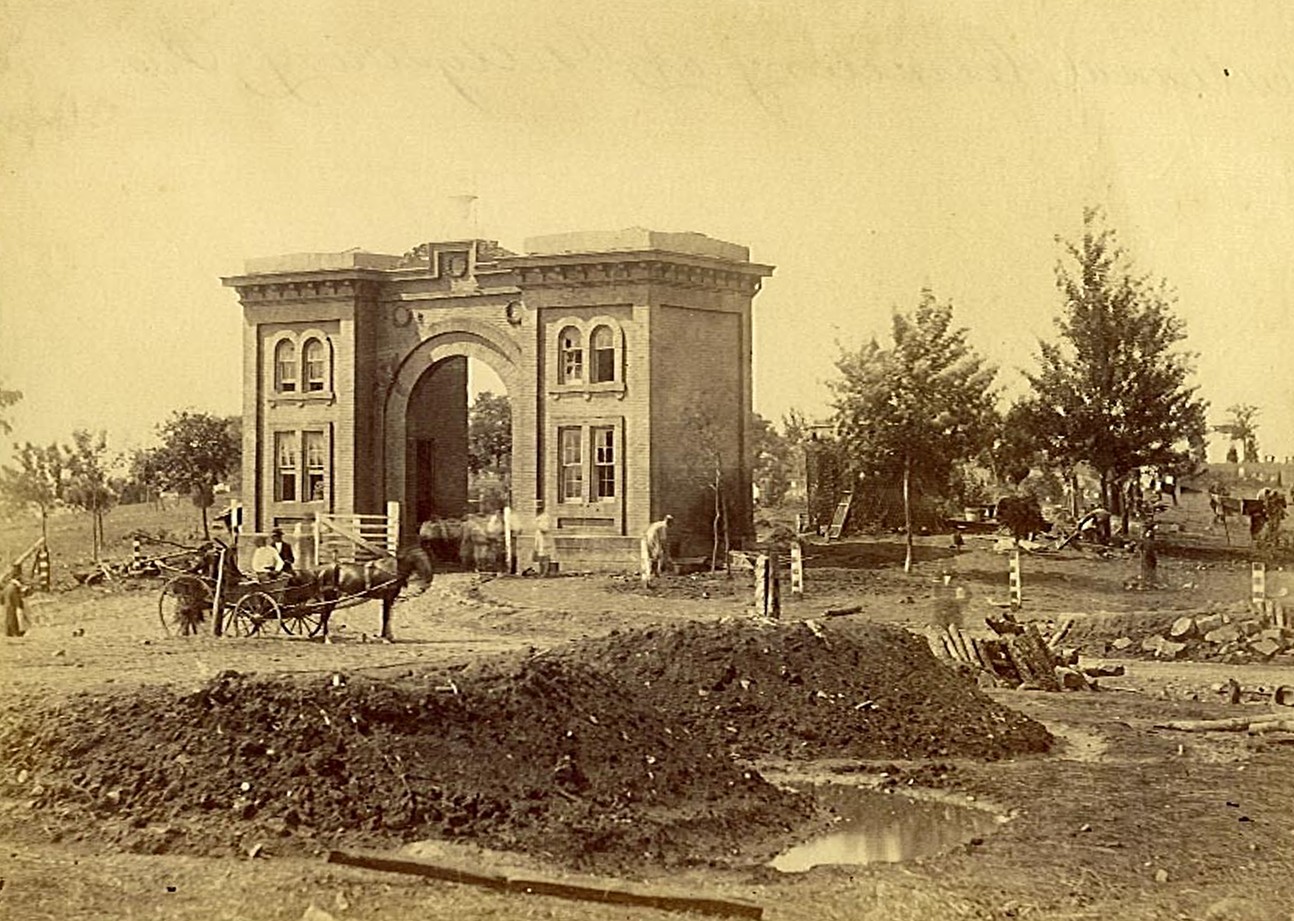
The Gateway/Gatehouse of the Evergreen Cemetery. This image also shows the lunettes of Lieutenant James Stewart’s Battery “B,” 4th United States Artillery. Note the puddles around the lunettes from the heavy rains following the battle This view, courtesy of the Library of Congress was taken facing southwest by Timothy O’Sullivan at approximately 11:00 AM on Tuesday, July 7, 1863.
In Video #2 Licensed Battlefield Guide John Archer shows how the elevation of East Cemetery Hill compares with some other prominent hills in the Gettysburg area. This video was taken facing south to northwest to southeast at approximately 4:45 PM on Friday, July 29, 2011.
John Archer is standing on the slope of East Cemetery Hill. The Gatehouse of Evergreen Cemetery and the position of Stewart’s Battery are in the background. This view was taken facing southwest at approximately 4:45 PM on Friday, July 29, 2011.
In Video #3 John Archer explains how this was the first ground preserved for future generations at Gettysburg, and shows us the Gatehouse and the current foliage on Cemetery Hill and East Cemetery Hill. This video was taken facing facing southwest at approximately 4:45 PM on Friday, July 29, 2011.