The Myth of Little Round Top Part 4: Gettysburg LBG Garry Adelman
April 8, 2010
Gettysburg Licensed Battlefield Guide Garry Adelman has been the host for the Myth of Little Round Top series. He is standing near the waysides on the summit of Little Round Top. In the right background is Cemetery Ridge and Cemetery Hill. In the left background are Plum Run Valley/Valley of Death, the South Mountains, Seminary Ridge, and the fields of the Trostle Farm, John Weikert Farm, Codori Farm, and Bliss Farm. Courtesy of Gettysburg National Military Park. This view was taken facing north at approximately 3:30 PM on Sunday, March 21, 2010.
A native of the Chicago area, Garry Adelman earned his B.A. in business from Michigan State University and his M.A. in history at Shippensburg University of Pennsylvania. He is the author or co-author of Antietam: Then & Now (2005), The Myth of Little Round Top (2003), The Early Gettysburg Battlefield (2001), Little Round Top: A Detailed Tour Guide (2000), and Devil’s Den: A History and Guide (1997). He has published articles in The Gettysburg Magazine and the Civil War Preservation Trust’s Hallowed Ground and has served as editor for several Civil War image booklets. He conceived and drafted the text for wayside exhibits at the Third Winchester, First Day at Chancellorsville, Cedar Mountain and the Slaughter Pen Farm battlefields. A frequent lecturer at Civil War Round Tables, he has also appeared as a speaker on the History Channel, C-Span, and Pennsylvania Cable Network. He is the vice president of the Center for Civil War Photography and a Licensed Battlefield Guide at Gettysburg. His The Civil War Then & Now: War in the East will be published in 2011. He works full time as a historian at History Associates Incorporated in Rockville, MD and in April 2010 will become the Civil War Preservation Trust’s full time Director of History and Education.
Little Round Top is one of the most well-known historical sites in the United States. This small hill south of Gettysburg has often been called the “key” to the Union position during the battle, and some have stated that if it had fallen to the Confederates on the afternoon of July 2, 1863, the United States would have forever been split in two. Garry Adelman traces the growth of the popularity of the hill and assesses the military situation at the time when Little Round Top might have fallen into Confederate hands. He argues that the significance of Little Round Top has been exaggerated, and even if Confederates had captured Little Round Top, they had only a small chance to hold it.
In our first Myth of Little Round Top post, Garry Adelman introduced us to the series, and showed us the initial placement of soldiers and Confederate assaults on the southwest face of Little Round Top.
In our second post, Gettysburg Licensed Battlefield Guide Garry Adelman showed the attack on the 20th Maine Infantry, and explained how the Little Round Top legend slowly grew over time.
In the third Myth of Little Round Top post, Gettysburg Licensed Battlefield Guide Garry Adelman continued his story of how Little Round Top’s importance grew over time, and showed us the strength of both armies at this critical point on the evening of July 2, 1863.
In today’s post, Garry concludes his Myth of Little Round Top series by pointing out Union artillery positions on Little Round Top and their effectiveness or lack of effectiveness on July 3, 1863.
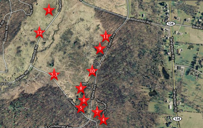
This map shows us the locations taken of the videos for The Myth of Little Round Top series. Video #1 was taken on Houck’s Ridge near Ayres Avenue. Videos #2 and #3 were taken on Warren Avenue, which is mislabeled Crawford Avenue on this Google Map. Video #4 was taken southeast of the monument to the 20th Maine Infantry Regiment. Video #5 was taken south of the 83rd Pennsylvania Infantry monument, near Warren Avenue. Video #6 was taken near the monument to the 83rd Pennsylvania Infantry Regiment. Video #7 was taken near the monument to the 20th Maine Infantry Regiment. Video #8 was taken below/south of the monument to the 44th New York Infantry Regiment. Video #9 was taken on the north side of Little Round Top near the monuments to the 146th New York Infantry Regiment, and the 155th Pennsylvania Infantry Regiment. Video #10 was taken near Hazlett’s Battery on the summit of Little Round Top. Video #11 was taken on the north side of Little Round Top near the monument to the 121st New York. Video #12 was taken in the Valley of Death near Crawford Avenue. This map was created facing north at approximately 7:00 PM on Monday, April 5, 2010.
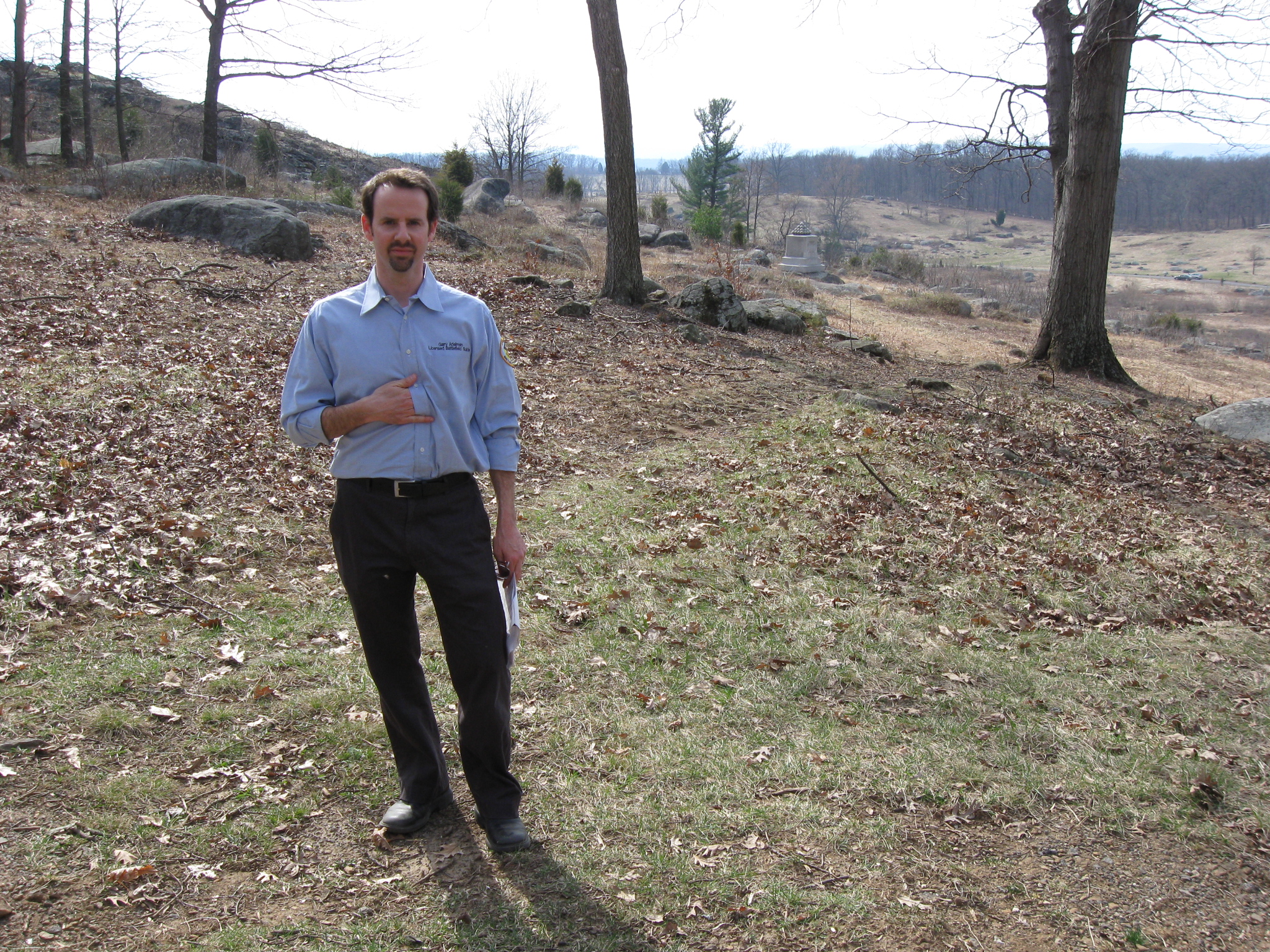
In Video #10 (Videos #1-#9 were shown in our previous posts) Gettysburg Licensed Battlefield Guide Garry Adelman shows how Union artillery had a difficult time firing on the Confederates during Pickett’s Charge from Little Round Top. Also, sensing that some don’t believe his facts and figures, he drives home his points with a raised voice and emphatic hand gestures. This view was taken facing southeast to north at approximately 3:30 PM on Sunday, March 21, 2010.
A Napoleonic Licensed Battlefield Guide Garry Adelman is on the north side of Little Round Top near the monument to the 121st New York Infantry Regiment, which is behind the photographer. The monument to Gibb’s Ohio Battery is in the right background. Above Gibbs Battery is Houck’s Ridge. This view was taken facing southwest at approximately 3:30 PM on Sunday, March 21, 2010.
In Video #11 Licensed Battlefield Guide Garry Adelman concentrates on the command structure, or lack of command structure for the Confederates on the evening of July 2, 1863, and the strength of the Union command structure on this end of the south end of the battlefield. This view was taken facing southwest to northeast to north at approximately 3:30 PM on Sunday, March 21, 2010.
Garry Adelman has now moved to Plum Run Valley/Valley of Death near Crawford Avenue. Little Round Top is in the background. This view was taken facing east at approximately 3:30 PM on Sunday, March 21, 2010.
In Video #12 Garry Adelman concludes the Myth of Little Round Top series with a recap of why it would have been very difficult for the Confederates to hold the hill, even if they had reached the summit on the afternoon/early evening of July 2, 1863. This view was taken facing east at approximately 3:30 PM on Sunday, March 21, 2010.