Licensed Battlefield Guide Rich Kohr: Gettysburg’s Electric Trolley Part 7
April 22, 2009
In today’s trolley post, we explore the tracks in the area of Devil’s Den. It is believed that there was a double set of tracks in this area. The photographer in this view is at Devil’s Den. The bridge on the right of this photo is where Old Warren Avenue (although we don’t believe it was called Warren Avenue) crossed Plum Run in the Slaughter Pen area. There is a foot bridge in this location today. Little Round Top is in the left background. This photograph is courtesy of Ben Dixon. This view was taken facing east between 1893 and 1902.
We are continuing our series on the Gettysburg Electric Trolley, which existed from 1893 to 1916. In our first trolley post, Gettysburg Licensed Battlefield Guide Rich Kohr took us from the Electric Power Station in the town of Gettysburg, over Cemetery Hill to Evergreen Cemetery. In our second post, Rich took the trolley out of Evergreen Cemetery, around the area of the “old” National Park Service Visitor Center, and showed how it was not allowed to continue along its proposed route on Cemetery Ridge. Our third post showed that because the trolley couldn’t travel on Cemetery Ridge, the “outbound” route needed to go to the Emmitsburg Road, where there were some other options, including double tracks at the Klingel Farm. The fourth trolley post took the trolley south along the Emmitsburg Road to where it turns on the Wheatfield Road at the Peach Orchard. The fifth trolley post took the trolley into the Wheatfield area. Our sixth trolley post covered “the big fill” near Plum Run, and the worst trolley accident. Today’s post covers the Devil’s Den area and an automobile-trolley accident. To contact Rich Kohr, click here to reveal his email address.
This map shows the route of the trolley. The red line is the trolley route. The green line is the route of the Gettysburg/Harrisburg/Reading Railroad. For some time, the trolley used the Gettysburg/Harrisburg/Reading Railroad line from the Emmitsburg Road to Little Round Top to help establish a circular route on the battlefield. The blue sections are where the trolley had double or passing tracks. The white stars are the locations where we filmed videos, which we have numbered. Today’s post features videos #s 25-27. This map was created at approximately 7:00 PM on Tuesday, April 21, 2009.
Gettysburg Licensed Battlefield Guide Rich Kohr is the host for our series on the Gettysburg Electric Railway or Gettysburg Trolley. Here he is standing by the modern footbridge near Devil’s Den in the Slaughter Pen area. The monument to the 4th Maine Infantry Regiment is in the background. “Old Crawford Avenue” was located behind the 4th Maine Monument, and “Old Warren Avenue” connected with Old Crawford Avenue near the 4th Maine Monument. Old Warren Avenue then came across Plum Run on a bridge where the current foot bridge is located. This view was taken facing northwest at approximately 3:30 PM on Sunday, March 22, 2009.
In Video #25 (Videos #1-24 were in our previous trolley posts) Gettysburg Licensed Battlefield Guide Rich Kohr explains the locations of “Old Crawford Avenue,” “Old Warren Avenue,” and their relationship with the trolley tracks in the Devil’s Den/Slaughter Pen area. This view was taken facing west to northeast to north at approximately 3:30 PM on Sunday, March 22, 2009.
Here is another view of Old Crawford Avenue and Old Warren Avenue taken from the larger rocks at Devil’s Den. Notice that Old Warren Avenue is to the right of the 4th Maine Monument in this photograph, and notice the trolley tracks running left to right (north to south) near the bridge. Little Round Top is in the left background. This photograph is courtesy of Ben Dixon. This view was taken facing east between 1893 and 1902.
Here is a photograph from a similar location as the previous picture, but notice that Warren Avenue is now behind the 4th Maine Monument in the same location that it is today. Modern Warren Avenue was constructed in 1902. Also notice the large rock near the intersection of the trolley tracks and current Warren Avenue. This might have contributed to a 1909 automobile and trolley accident we will discuss a little later in this post. This photograph is courtesy of the National Park Service. This view was taken facing northeast at approximately between 1902 and 1916.
The “modern” Warren Avenue Bridge over Plum Run soon after its construction in 1902. The monument to the 40th New York Infantry Regiment is in the background. This photograph is courtesy of the Ben Dixon. This view was taken facing north circa 1902.
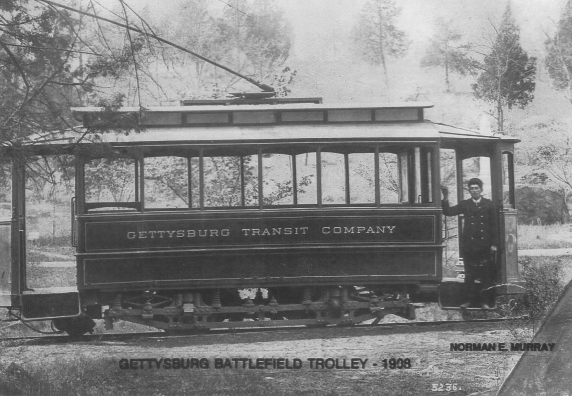
This car at Devil’s Den is closed for cooler weather. Devil’s Den is in the background. The monument to the 4th Maine Infantry Regiment is visible behind the driver, Norman Murray. Because this is one of the smaller trolley cars, it is probably the Sedgwick, which was involved in the head on trolley collision which we discussed in trolley post #6. This photograph is courtesy of the National Park Service. This view was taken facing west in 1908.
Rich Kohr is standing on Warren Avenue near its intersection with the trolley line. The Warren Avenue Bridge over Plum Run is behind (west of) the camera man. Little Round Top is in the background, as is the castle-like monument to the 44th New York Infantry Regiment. This view was taken facing east at approximately 3:30 PM on Sunday, March 22, 2009.
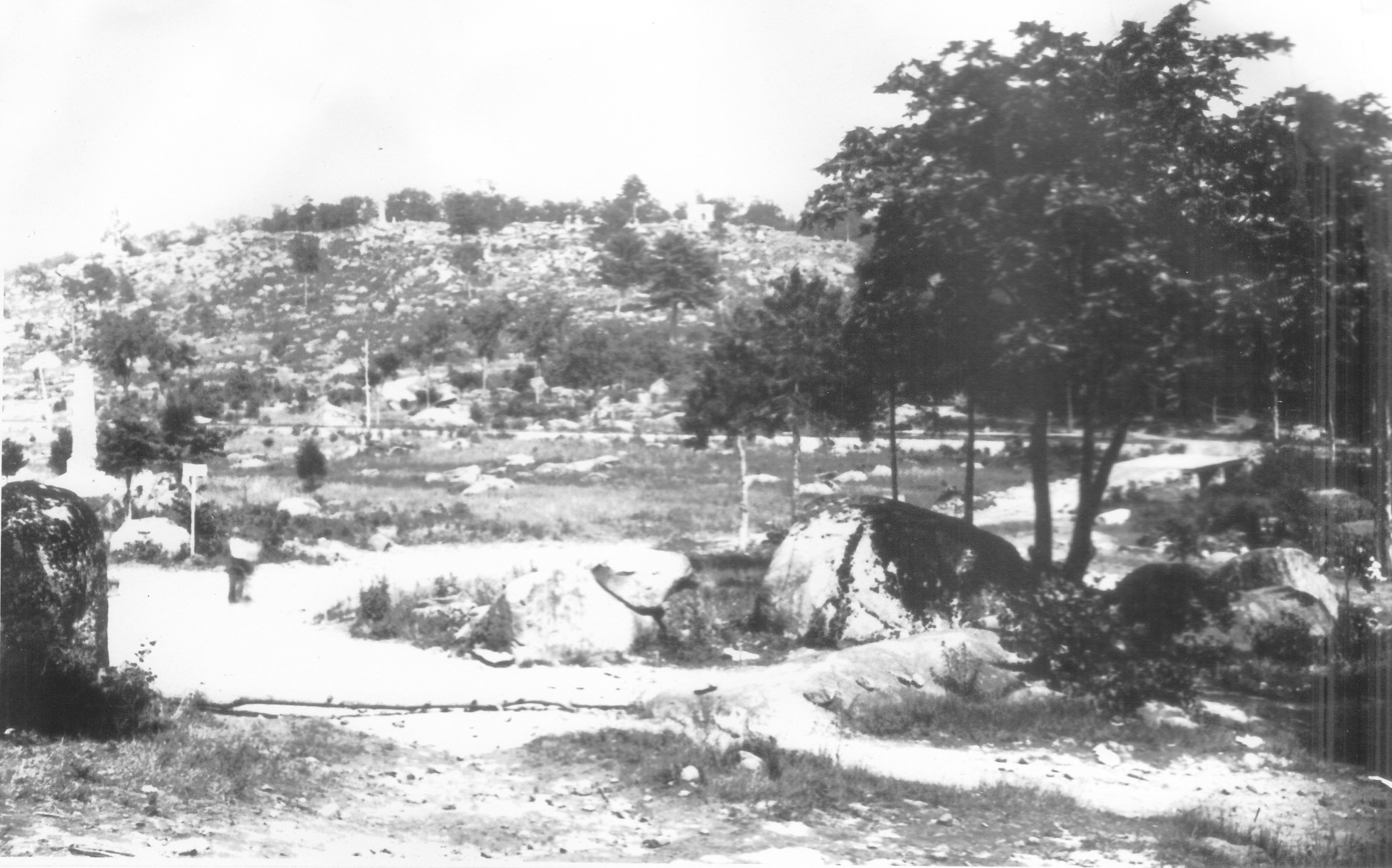
Here is the photograph that Rich was showing us in the previous picture. Notice the vegetation on either side of Warren Avenue near the trolley tracks. There is also a rock on the left side of the road near the tracks. The vegetation and a large rock out of sight in this view, but on the right side of the road, contributed to an automobile-trolley accident here in 1909. This photograph is courtesy of the National Park Service. This view was taken facing east between 1902 and 1916.
In Video #26 Rich Kohr explains where the trolley tracks crossed Warren Avenue. This view was taken facing west to northeast to north at approximately 3:30 PM on Sunday, March 22, 2009.
Rich is standing on the rock that the automobile hit in an accident with a trolley car on July 4, 1909. The trolley tracks would have been this side of (west of) the rocks, running left to right (north to south). This view was taken facing east at approximately 3:30 PM on Sunday, March 22, 2009.
In Video #27, Rich explains how the automobile/trolley accident occurred on July 4, 1909. This view was taken facing east to south to east at approximately 3:30 PM on Sunday, March 22, 2009.
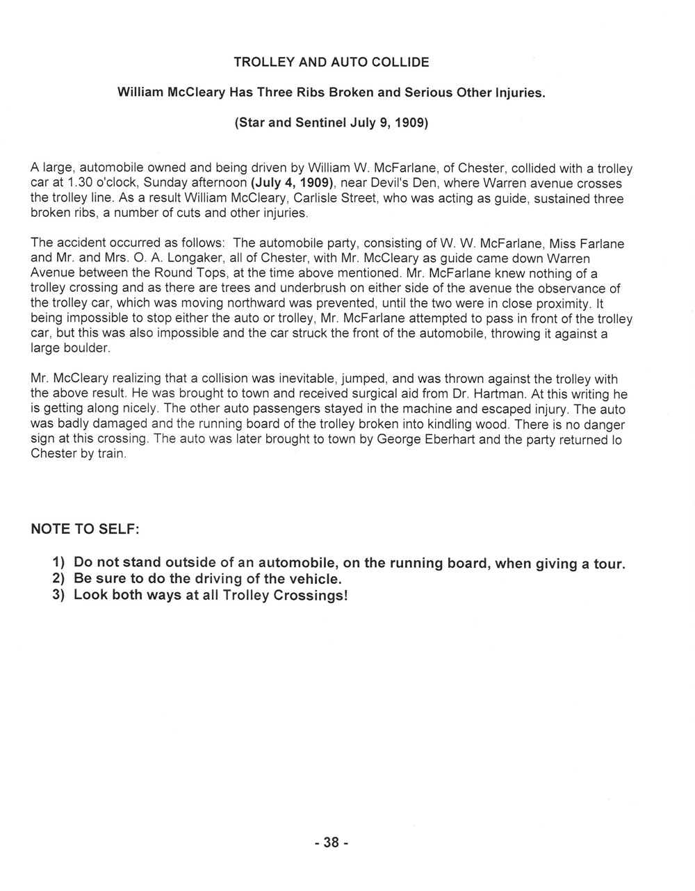
Here is a newspaper article describing the automobile trolley accident on July 4, 1909. To view the article in PDF format, click here. This page was scanned facing south at approximately 8:00 PM on Thursday, January 1, 2009.
In our next trolley post, we’ll take the trolley across Plum Run Valley (Valley of Death) to its terminus on the north side of Little Round Top. This photograph is courtesy of the National Park Service. This view was taken facing east between 1893 and 1916.
To see other posts by Gettysburg Licensed Battlefield Guides,click here.