On the afternoon of July 1, 1863, the Confederate brigade of Brigadier General John Brown Gordon attacked Barlow’s Knoll/Blocher’s Knoll. They crossed Rock Creek, which is marked by the trees at the bottom of the hill, and moved uphill to the position marked by their brigade tablet. A soldier in the 61st Georgia Infantry Regiment of Gordon’s Brigade, Private Franklin Butts was mortally wounded during the attack. He is buried at Laurel Grove Cemetery in Savannah, Georgia. This view was taken facing east at approximately 7:30 AM on Sunday, October 23, 2011.
The Gettysburg Daily took a journey to the Savannah, Georgia area in April, 2011. One of our purposes for the visit was to find Civil War events/personalities associated with Gettysburg.
In our first Savannah post we showed the monument and the grave of Confederate Major General Lafayette McLaws.
In our second Savannah at Gettysburg post, we showed the monument and the grave of Colonel Francis S. Bartow. They are very similar to the monument and grave of Lafayette McLaws.
In the third Savannah at Gettysburg post, we gave an overall view of “Gettysburg Field” in Laurel Grove Cemetery and concentrate on the statue “Silence” in the midst of Confederates removed from Gettysburg to Savannah.
In our fourth Savannah at Gettysburg post, we looked at how difficult it is to match one of the soldiers buried in Laurel Grove Cemetery with his unit that fought at Gettysburg.
In the fifth Savannah at Gettysburg post, we looked up information about another individual buried in Laurel Grove, Major Peter Brenan, and whose headstone is somewhat misleading.
In the sixth Savannah at Gettysburg post, we looked up information on Captain John Mitchel Dooly Bond II, a member of the 53rd Georgia Infantry Regiment, and who was killed on July 2, 1863.
In today’s Savannah at Gettysburg post, we attempt to discover information on Private Franklin Butts, a member of the 61st Georgia Infantry Regiment, who was mortally wounded on July 1, 1863.
This map shows the two areas in Savannah featured in these posts. #1 is the area of the Confederate Monument in Forsyth Park. #2 is Laurel Grove Cemetery. This view was taken facing north at approximately 8:30 PM on Friday, April 29, 2011.
This is the brochure given out to those who visit Laurel Grove Cemetery is which southwest of Savannah’s Historic District. It is a handy size and points out some of the important people buried in the cemetery. There is another map which we were given that lists each burial plot, but that was too big for our scanner. In our previous Savannah posts we walked from the Circle surrounded by Cypress, Cedar, Willow and Elm Streets to the McLaws grave in the northeast quadrant, with the red star and the “M.” In our second post we continued our walk to the grave of Francis Bartow, which is the red star with a “B.” In today’s post we walked to the most well known Confederate section of Laurel Grove Cemetery which is marked with a “C.” This view was taken facing west at approximately 5:30 PM on Saturday, May 7, 2011.
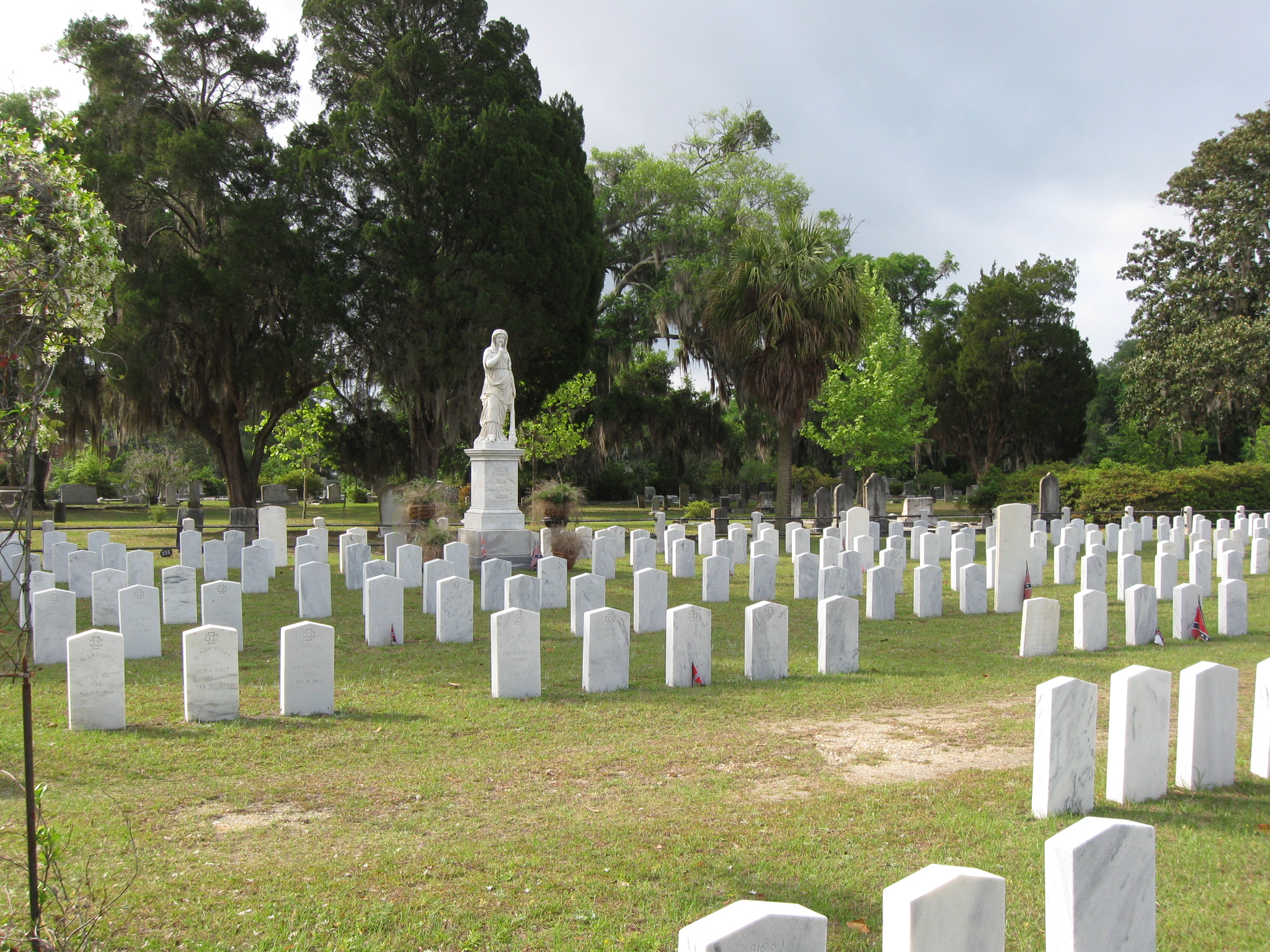
In Savannah, Georgia’s Laurel Grove Cemetery there is a section for Confederate soldiers. This area has been variously called “Confederate Field” or “Gettysburg Field.” Of the approximately 700 Confederates buried in this section of the cemetery, comparatively very few are Gettysburg casualties. Most of the Gettysburg dead are buried near the “Silence” monument. We are seeing what information that we can gather on the men that fought and possibly died at Gettysburg. We are looking at an individual on the front row, to the right of the stone with the Confederate flag. This view was taken facing southeast at approximately 10:30 AM on Friday, April 22, 2011.
The stone for Frank Botts, like other stones we have seen at Laurel Grove has a few problems with it. First, this soldier’s name is Franklin Butts, not Botts. Also, the stone states “Co. E.” Franklin Butts was in Company K of the 61st Georgia Infantry Regiment. Nobody else in the regiment had the name of Botts or Butts. The Compiled Service Records also show that his rank was that of a Private. This view was taken facing east at approximately 12:00 PM on Saturday, May 21, 2011.
Private Franklin Butts enlisted in Company D of the 26th Georgia Infantry Regiment on September 1, 1861 “for the war.” Unfortunately, we could not find Franklin Butts on the 1860 Federal Population Census for Tattnall County, Georgia. Tattnall County is located in southeastern Georgia. Company D of the 26th Georgia Infantry Regiment “subsequently became Company B, 61st Regiment Georgia Infantry. The regiment was successively designated as 26th Regiment (Lamar’s) Georgia Infantry, 7th Battalion Georgia Infantry and 61st Regiment Georgia Infantry.” This view was taken facing southeast at approximately 12:00 PM on Saturday, May 21, 2011.
Franklin Butts remained a Private from the time he enlisted until he was mortally wounded/killed at Gettysburg. It appears he was a solid soldier. He is shown as “Present,” on every muster roll for his unit from October 1861 until June 30, 1863 with the exception of one muster roll. The muster roll for April 30, 1863 shows him “Absent, Detailed as teamster since January 2, 1863.” The muster roll for April 30, 1862 showed him detailed as a teamster, but listed him as “Present.” He was shown as “Present, Transferred from Company B to form Company K by authority of Brig. Genl. H. W. Mercer” on the muster roll which was dated circa May 31, 1862. So Franklin Butts was always doing his duty, sometimes as a teamster. As far as we can tell from his military records, he does not show up on any hospital lists, and he never took leave. This view was taken facing southeast at approximately 10:30 AM on Friday, April 22, 2011.
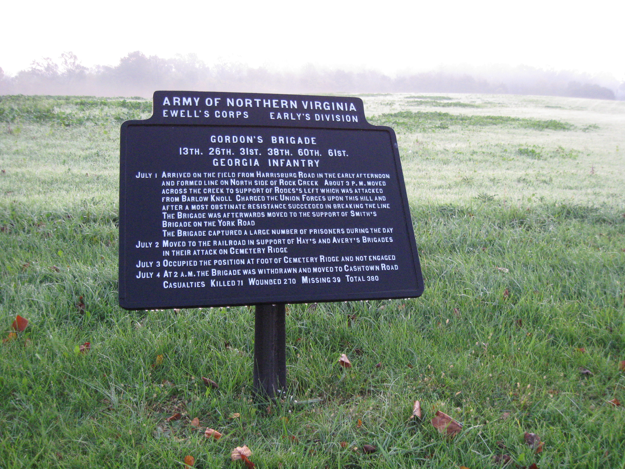
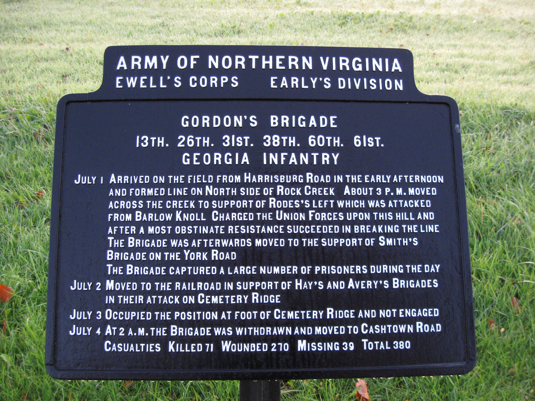
At Gettysburg, the 61st Georgia Infantry Regiment was in Brigadier General John Brown Gordon’s Brigade, Major General Jubal A. Early’s Division, Lieutenant General Richard S. Ewell’s Corps. This plaque is located in the area of Blocher’s Knoll/Barlow’s Knoll. This view was taken facing east at approximately 7:30 AM on Sunday, October 23, 2011.
This map shows some Gettysburg areas related to Private Franklin Butts and the 61st Georgia Infantry Regiment. Gordon’s Brigade and the 61st Georgia moved south on the Harrisburg Road (Old Harrisburg Road) and in the area of the Josiah Benner Farm (shown as the white star labeled “BF”) they attacked roughly from northeast to southwest. They crossed Rock Creek (shown as the white star labeled “RC”). They then drove soldiers from the Union’s Eleventh Corps off of Blocher’s Knoll/Barlow’s Knoll (shown as the white star labeled “BK”). Franklin Butts was buried at the Benner Farm before his body was removed to Laurel Grove Cemetery in Savannah. This map was created facing north at approximately 9:45 AM on Sunday, October 23, 2011.
As Gordon’s Brigade began their attack at Gettysburg on July 1, 1863, towards Union positions on Barlow’s Knoll (out of sight behind the trees in the right background), they were on the right or west side of the Harrisburg Road, on the same side as the Josiah Benner Farm. A clear view of the barn is obstructed by the construction vehicles sometimes being utilized on the North Gettysburg Trail. This view was taken facing southwest at approximately 7:30 AM on Sunday, October 23, 2011.
The construction vehicles also partially obscure the Josiah Benner House, which the National Park Service recently acquired. This view was taken facing southwest at approximately 7:45 AM on Sunday, October 23, 2011.
Rock Creek is marked by the bridge on the Harrisburg Road as the road curves to the left in the background. The Josiah Benner Spring house is on the right side of the road and to the right of the white picket fence. Brigadier General John Brown Gordon wrote in his report of the battle: “About 3 p.m. I was ordered to move my brigade forward to the support of Major-General Rodes’ left. The men were much fatigued from long marches, and I therefore caused them to move forward slowly until within about 300 yards of the enemy’s line, when the advance was as rapid as the nature of the ground and a proper regard for the preservation of my line would permit.” This view was taken facing southwest at approximately 7:45 AM on Sunday, October 23, 2011.
Because a group from the 17th Connecticut occupied the buildings around the Benner Farm, it appears most of Gordon’s Brigade moved to the right of the buildings. The Benner House is on the left. The other outbuildings are post Civil War structures. This view was taken facing south at approximately 7:45 AM on Sunday, October 23, 2011.
Gordon states that his men moved “forward under heavy fire over rail and plank fences…” However that doesn’t mean that this picket fence wasn’t here at the time of the battle. This view was taken facing southwest at approximately 7:45 AM on Sunday, October 23, 2011.
Gordon’s Georgians, and Private Franklin Butts, if he had not yet been hit, would have moved into the woods along Rock Creek. Here’s the remains of a reproduction post and rail fence. Gordon did not state in what order his regiments were positioned when they made their advance, except to say that the 26th Georgia had been detached to provide support to Jones’ Artillery Battalion. This view was taken facing southwest at approximately 7:45 AM on Sunday, October 23, 2011.
Gordon said that his Georgians crossed “a creek whose banks were so abrupt as to prevent a passage excepting at certain points, this brigade rushed upon the enemy with a resolution and spirit, in my opinion, rarely excelled.” Today the banks of Rock Creek are not very steep because the rains over the last couple of months have significantly raised the water level. This view was taken facing northwest at approximately 7:45 AM on Sunday, October 23, 2011.
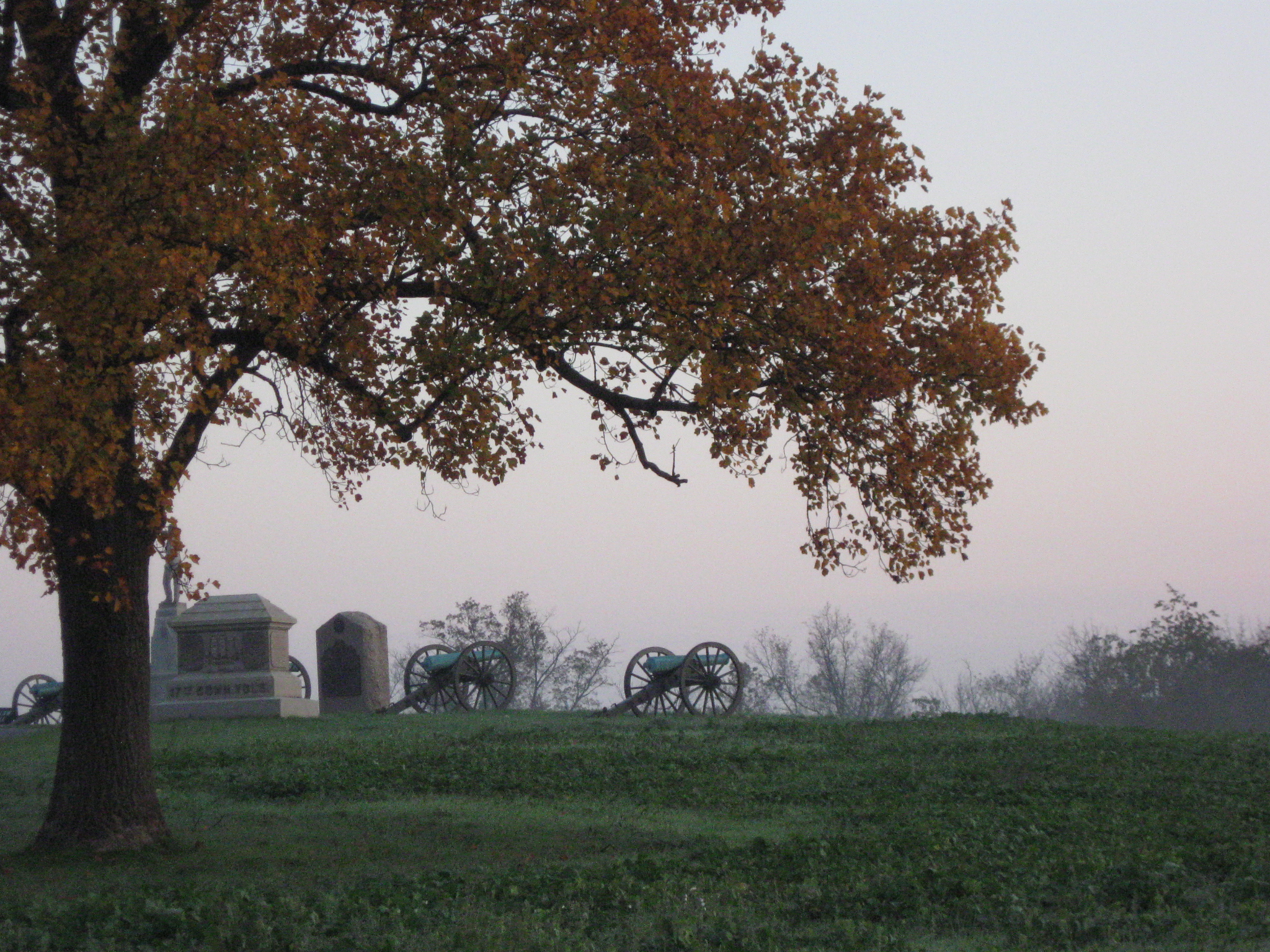
Gordon’s Georgians advanced up the slope of Barlow’s Knoll/Blocher’s Knoll. We are standing at the top of the knoll. The trees are along Rock Creek. The Confederates moved towards the position of the camera. The artillery pieces mark the position of First Lieutenant Bayard Wilkeson’s Battery G, Fourth United States Artillery. This view was taken facing east at approximately 7:45 AM on Sunday, October 23, 2011.
In his report, Gordon stated that as his regiments advanced, “The enemy made a most obstinate resistance until the colors on portions of the two lines were separated by a space of less than 50 paces, when his line was broken and driven back…” The artillery pieces mark the location of Battery G, 4th United States Artillery. The flagpole marks the spot where Lieutenant Colonel Douglas Fowler of the 17th Connecticut was killed. The Bugler stands atop the monument to the 153rd Pennsylvania Infantry. This view was taken facing west at approximately 7:45 AM on Sunday, October 23, 2011.
The Confederates then poured over Barlow’s Knoll, moving towards the camera position. On the left is the plaque to Adelbert Ames’ Brigade. Monuments at the top of Blocher’s Knoll include from left to right: 153rd Pennsylvania (mostly hidden by a tree), 25th and 75th Ohio, Francis C. Barlow, Battery G, 4th United States Artillery, and the 17th Connecticut. This view was taken facing northeast at approximately 7:45 AM on Sunday, October 23, 2011.
Gordon’s report states that an effort was made by the division of Brigadier General Francis C. Barlow to “check our advance, but the effort failed, and this line, too, was driven back in the greatest confusion, and with immense loss in killed, wounded, and prisoners. Among the latter was a division commander (General F.C. Barlow), who was severely wounded.” The Barlow statue is on the right. This view was taken facing northeast at approximately 7:45 AM on Sunday, October 23, 2011.
Barlow, in a letter to his mother on July 7, 1863 did not give his men the credit that Gordon’s report did. Barlow writes: “A force came up against our front in line of battle with supports in the rear. We ought to have held the place easily, for I had my entire force at the very point where the attack was made. But the enemies skirmishers had hardly attacked us before my men began to run. No fight at all was made. Finding that they were going I started to get a head of them to try to rally them and form another line in the rear. Before I could turn my horse I was shot in the left side about half way between the arm pit and the head of the thigh bone.” The markers and statues from left to right are: Gordon’s Brigade plaque, 25th and 7th Ohio Monument, Barlow Statue, 17th Connecticut Monument, Lieutenant Colonel Douglas Fowler flagpole, 153rd Pennsylvania Monument, and the marker and guns for Wilkeson’s Battery G, 4th United States Artillery. The Georgians advanced towards the camera, and from right to left. This view was taken facing northwest at approximately 7:45 AM on Sunday, October 23, 2011
The markers monuments from left to right are: Barlow’s Division marker, Barlow statue, 153rd Pennsylania Monument, Fowler flagpole, Battery G, 4th United States Artillery marker, 17th Connecticut Monument, and the marker for Gordon’s Brigade. During the Battle of Gettysburg, Gordon had approximately 1813 men engaged, and suffered losses of 537 or 29.6%. Most of their losses were on July 1, 1863. This view was taken facing southeast at approximately 7:45 AM on Sunday, October 23, 2011.
The 61st Georgia had 288 men engaged, with 111 casualties, or 38.5%. This view was taken facing southeast at approximately 7:45 AM on Sunday, October 23, 2011.
The artillery pieces belonging to Battery G, 4th United States Artillery were not captured. They began to move off the knoll as the Confederate attack reached Rock Creek. This view was taken facing northeast at approximately 7:45 AM on Sunday, October 23, 2011.
It is not known where Private Franklin Butts fell in this advance. We are looking at the back of the plaque to Gordon’s Brigade. To the left of the marker to Gordon’s Brigade is the marker to Barlow’s Division. Behind the Barlow’s Division marker is the Alms House Cemetery. In the left background is the monument to the 107th Ohio. This view was taken facing northwest at approximately 7:45 AM on Sunday, October 23, 2011
It is not known for sure if Private Franklin Butts was wounded and lived for a little while after his wound, or if he was killed instantly. The evidence from looking at the military records leads one to believe he was wounded but died before July 10, 1863 when the final report of casualties was submitted for Gordon’s Brigade. That report shows that Franklin Butts was “killed.” We are on Barlow’s Knoll looking towards the area where the Adams County Alms House was located. The road is East Howard Avenue. At the bottom of the hill to the left of the avenue is the marker for Gordon’s Georgia brigade. To the right of the avenue is the marker to Barlow’s Division. In the right background is the Alms House Cemetery. This view was taken facing southwest at approximately 7:45 AM on Sunday, October 23, 2011.
Private Franklin Butts was shown as “Absent, Wounded” on the muster roll for June 30, 1863. Because other records show that he was “killed” on July 1, 1863 the June 30th muster roll must have actually been created after Butts was wounded on July 1, 1863. Since records show that he was buried at the Benner Farm, he was probably a patient at the hospital located here before he died. The Benner House is on the left. The Benner Barn is in the right background. This view was taken facing northeast at approximately 7:45 AM on Sunday, October 23, 2011.
It is likely that Private Franklin Butts was cared for in the Josiah Benner barn. This view was taken facing north at approximately 7:45 AM on Sunday, October 23, 2011.
Accounts seem to suggest that mostly wounded officers were taken care of in the Josiah Benner House. This view was taken facing northwest 7:45 AM on Sunday, October 23, 2011.
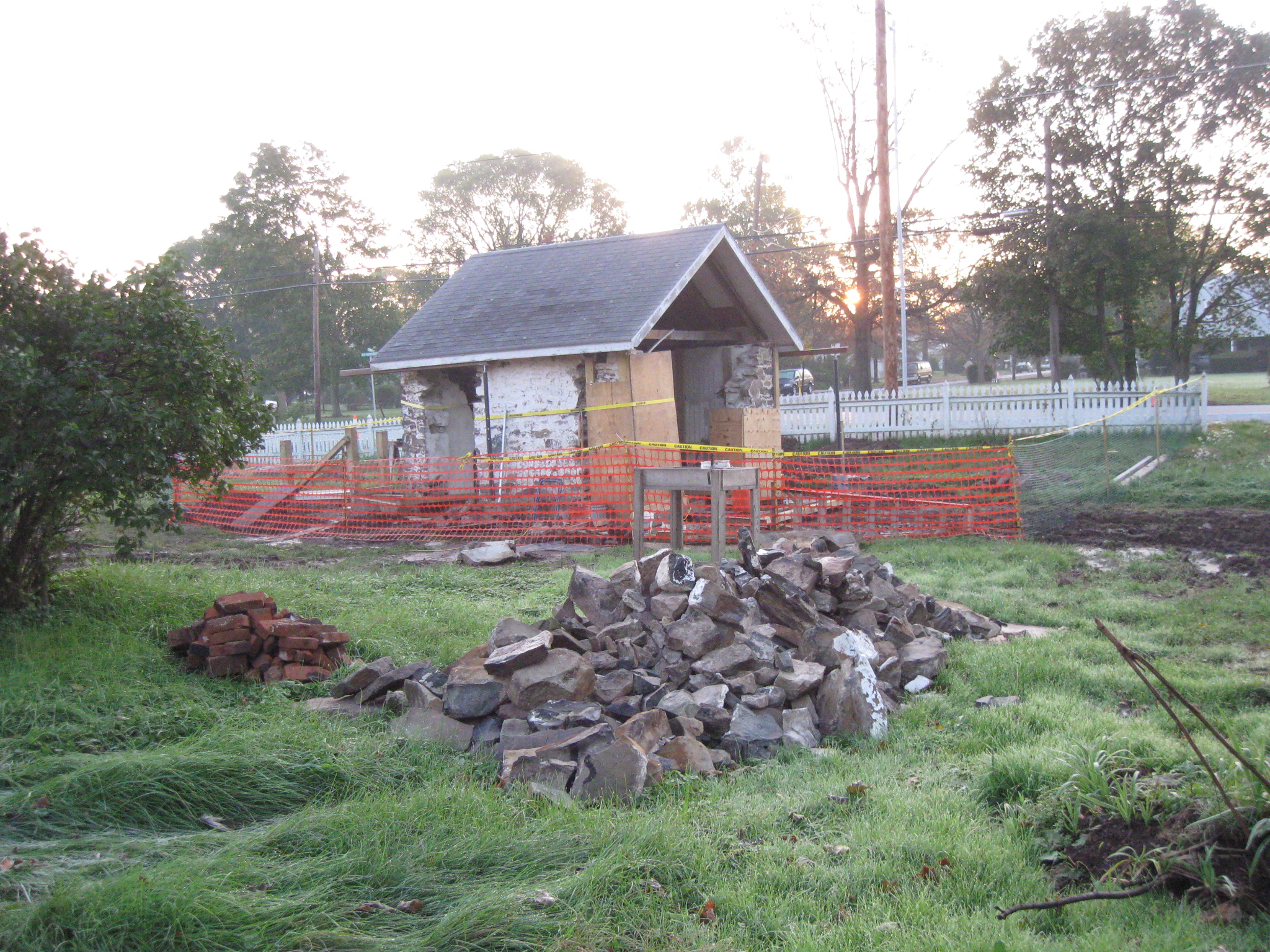
Whatever location he was placed, the house on the left, or the barn on the right, we hope that he was brought water from the springhouse, which is closest to the camera. This view was taken facing north at approximately 7:45 AM on Sunday, October 23, 2011.
The springhouse may have been originally constructed before the American Revolution. It is now being reconstructed by the National Park Service. When John Reid owned this land in 1776, the farm was known as “Spring Garden.” The springhouse was noted for its excellent quality of water, “some of the purest and coldest in the Gettysburg area.” This view was taken facing east at approximately 7:45 AM on Sunday, October 23, 2011.
Private Franklin Butts of the 61st Georgia Infantry Regiment was one of fourteen United States’ soldiers and eleven Confederate States’ soldiers buried on the Josiah Benner Farm. This view was taken facing northwest at approximately 7:45 AM on Sunday, October 23, 2011.
It is not known when his body was brought to Savannah for burial, but it was after the initial removals in August, 1871. This view was taken facing south at approximately 10:30 AM on Friday, April 22, 2011.
A history of the 61st Georgia Infantry Regiment is: A Soldier’s Story of His Regiment (61st Georgia), And Incidentally of the Lawton-Gordon-Evans Brigade, Army of Northern Virginia. It was written by Private George Washington Nichols in 1898. It is not a perfect work, as it has Private Franklin Butts killed at the Battle of Second Manassas in August, 1862, and killed at Gettysburg in July, 1863, but it has been reprinted with a new introduction by Keith Bohannon. For ordering information, click here. This image was copied facing north at approximately 4:00 PM on Sunday, October 23, 2011.