

This image is titled “Old Cast-Iron Gun Carriage, Formerly Used to Mark the Field.” The location is at the position of the 2nd Connecticut Artillery Battery on Cemetery Ridge. The 1895 commission report states: “The volunteer batteries of the Union Army on the grounds of the Memorial Association are generally represented by one gun and mounted upon inferior carriages. This commission resolved to substitute an improved iron gun carriage. Sixty-two new carriages have been contracted for. Of these about 36 have been furnished by the contractor and placed on the field and mounted with the kind of gun used by each battery, respectively in the battle. The others will be put in position as soon as supplied by the contractor. Excellent granite foundation stones support each carriage. The following have already been placed on the Union lines, …(page 22) Editor’s Note: None of the batteries mentioned were along Cemetery Ridge in the 1895 report. This photograph was taken facing southwest circa 1895. Annual Reports of the Gettysburg National Military Park Commission to the Secretary of War, 1893-1904. Washington. Government Printing Office, 1905.
One of our favorite parts about running Gettysburg Daily has been making available images and documents to the public. It is a strong belief of ours that historic photographs and images should be freely accessible to all. Today we’re presenting you a preview of the Cemetery Ridge “sources” pages that we’ll be adding to the site in the coming months. We previously showed you images from Seminary Ridge back in April.

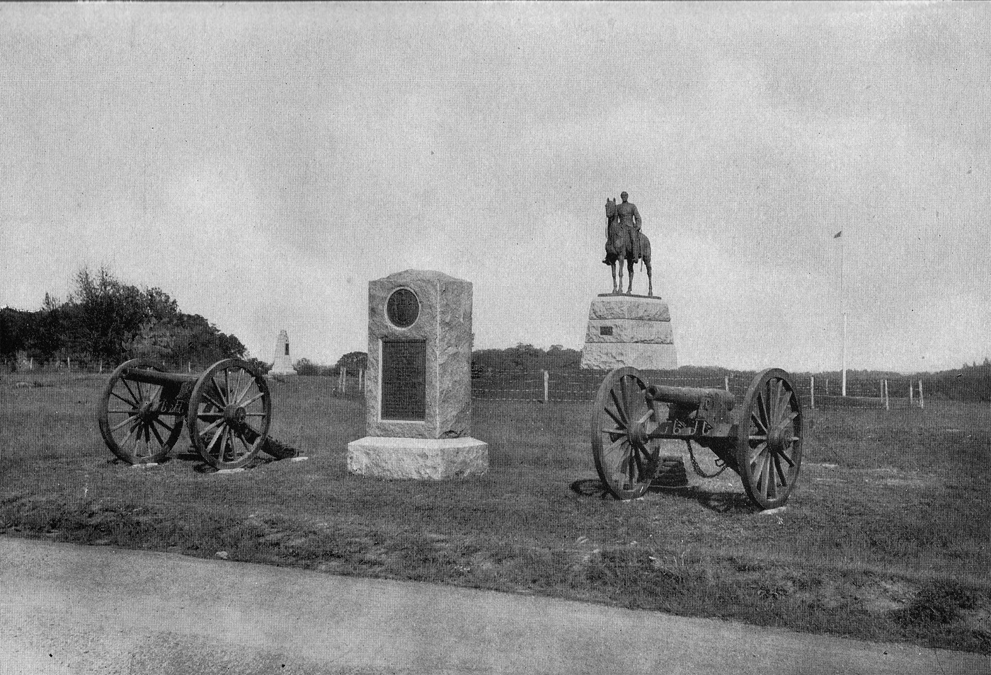
This image is titled “Hancock Avenue, Tower, Bryan House.” The location is the “High Water Mark” area on Cemetery Ridge. The Annual Report of the Gettysburg National Military Park Commission to the Secretary of War in 1896 states: “Since our report of 1895 the Telford road, known as Seminary avenue, and section 1 of Confederate avenue, running from the Chambersburg pike southward along Seminary Ridge as far as the Government at present owns the right of way there, has been completed; likewise Hancock Avenue which runs from the national cemetery gate southward along the main Union line of battle to the east end of United States avenue…” (page 29) On the left is a cannon and the monument to Arnold’s Battery A, 1st Rhode Island Artillery. To its right is the monument to the 14th Connecticut Infantry Regiment. The Bryan House is the white structure at the “end” of Hancock Avenue. Actually Hancock Avenue is to the left (west) of the Bryan House in that location. The monument to the 125th New York Infantry Regiment. The tall monument just to the right (east) of Hancock Avenue is to the 39th New York Infantry Regiment. The Ziegler’s Grove Tower is prominent on the horizon. Below the tower is a monument and guns marking the position of Battery K, 1st New York Light Artillery and the 11th New York Independent Battery. The trees that make up Ziegler’s Grove dominate the right background. Partially hidden behind a small tree on the other (north) side of a stone wall is the monument to the 99th Pennsylvania Infantry Regiment. In the right background is the equestrian monument to Major General George Gordon Meade. This view was taken facing north circa 1896.
This image is titled “Hancock Avenue; Eleventh New York Independent Battery” The location is the “High Water Mark” area on Cemetery Ridge. The Annual Report of the Gettysburg National Military Park Commission to the Secretary of War in 1896 states: “Since our report of 1895 the Telford road, known as Seminary avenue, and section 1 of Confederate avenue, running from the Chambersburg pike southward along Seminary Ridge as far as the Government at present owns the right of way there, has been completed; likewise Hancock Avenue which runs from the national cemetery gate southward along the main Union line of battle to the east end of United States avenue…” (page 29) Hancock Avenue is in the foreground. In the background is the equestrian monument to Major General George Gordon Meade. In the right background is the flagpole then located at Meade’s Headquarters, the Leister House, along the Taneytown Road. The guns and monument are for the 11th New York Independent Battery, which was attached to Battery K, 1st New York Artillery. In the left background are trees in Ziegler’s Grove. To the right of the Ziegler’s Grove trees, and above the left cannon is the monument to the 10th New York Infantry Regiment. Culp’s Hill is seen between the Meade Equestrian Statue and the Eleventh New York Artillery Monument. This view was taken facing northeast circa 1896.
This image is titled “Hancock Avenue; Loop at the Angle” The location is the “High Water Mark” area on Cemetery Ridge. The Annual Report of the Gettysburg National Military Park Commission to the Secretary of War in 1896 states: “Since our report of 1895 the Telford road, known as Seminary avenue, and section 1 of Confederate avenue, running from the Chambersburg pike southward along Seminary Ridge as far as the Government at present owns the right of way there, has been completed; likewise Hancock Avenue which runs from the national cemetery gate southward along the main Union line of battle to the east end of United States avenue…” (page 29) Hancock Avenue is in the foreground. The “Loop” was known as Webb Avenue. From left to right is: Marker for Lieutenant Alonzo Cushing, Marker for Brigadier General Lewis Armistead, 72nd Pennsylvania Infantry Monument, Codori Farm, treeline on the horizon is Seminary Ridge, the monument on the right is to the 71st Pennsylvania Infantry Regiment. This view was taken facing southwest circa 1896. Annual Reports of the Gettysburg National Military Park Commission to the Secretary of War, 1893-1904. Washington. Government Printing Office, 1905.
This image is titled “Hancock Avenue. North to High-Water Mark.” The location is south of the “High Water Mark” area on Cemetery Ridge. The Annual Report of the Gettysburg National Military Park Commission to the Secretary of War in 1896 states: “Since our report of 1895 the Telford road, known as Seminary avenue, and section 1 of Confederate avenue, running from the Chambersburg pike southward along Seminary Ridge as far as the Government at present owns the right of way there, has been completed; likewise Hancock Avenue which runs from the national cemetery gate southward along the main Union line of battle to the east end of United States avenue…” (page 29) Hancock Avenue goes in two different directions at this location, on the left and right of the grassy area. From left to right is: Monument for 82nd New York (partial view), Monument for 1st Minnesota, Monument for 15th Massachusetts (dark colored monument, Monument for 19th Maine Infantry (light colored monument. The Copse of Trees is in the center background. The monument and two cannon on the right of this view is to Captain James Rorty’s Battery B, 1st New York Light Artillery. To the left of the artillery pieces, the equestrian monument to Major General George Gordon Meade is visible on the horizon. To the left of the Meade statue is the monument to the 42nd New York Infantry Regiment. This view was taken facing north circa 1896. Annual Reports of the Gettysburg National Military Park Commission to the Secretary of War, 1893-1904. Washington. Government Printing Office, 1905.

This image is titled “Hancock Avenue at Intersection of Pleasonton Avenue.” The location is in the area of where the Pennsylvania State Memorial is now located. The Pennsylvania State Memorial now sits in the orchard in the left background. The Annual Report of the Gettysburg National Military Park Commission to the Secretary of War in 1896 states: “Since our report of 1895 the Telford road, known as Seminary avenue, and section 1 of Confederate avenue, running from the Chambersburg pike southward along Seminary Ridge as far as the Government at present owns the right of way there, has been completed; likewise Hancock Avenue which runs from the national cemetery gate southward along the main Union line of battle to the east end of United States avenue…” (page 29) We are looking down Hancock Avenue which then goes off to the right in this view. Pleasonton Avenue enters Hancock Avenue from the left and forms a junction in the center of this view. The monument and artillery pieces on the left are to Battery K, 1st New York Light Artillery. They are now located closer to the High Water Mark near the 11th New York Independent Battery. On the right is the monument to Company E of the 1st Regiment United States Sharpshooters and to Company F and company G of the 2nd Regiment United States Sharpshooters. These companies of sharpshooters were from New Hampshire. To the left of that monument is the July 3rd marker for the 17th Maine Infantry Regiment. To its left is the monument and cannon marking the position of the 9th Michigan Artillery. The tall monument visible on the right side of Hancock Avenue is to the 1st Minnesota Infantry Regiment. On the left side of Hancock Avenue, and not very visible is the monument to Battery A, 1st New Jersey Light Artillery (Hexamer’s New Jersey Battery). This view was taken facing southeast circa 1896. Annual Reports of the Gettysburg National Military Park Commission to the Secretary of War, 1893-1904. Washington. Government Printing Office, 1905.
This image is titled “Intersection United States Avenue and Hancock Avenue.” The location is on Cemetery Ridge in the area of the George Weikert Farm, which is visible in the left background. The Annual Report of the Gettysburg National Military Park Commission to the Secretary of War in 1896 states: “Since our report of 1895 the Telford road, known as Seminary avenue, and section 1 of Confederate avenue, running from the Chambersburg pike southward along Seminary Ridge as far as the Government at present owns the right of way there, has been completed; likewise Hancock Avenue which runs from the national cemetery gate southward along the main Union line of battle to the east end of United States avenue…” (page 29) “In appropriate and needful places we have caused the avenues which have been made to be inclosed with the neat style of fence described in our last annual report, which, being made of iron-capped locust posts and four galvanized iron railings, is not only durable but is inconspicuous to the sight, and therefore does not mar the view of the field” (page 30). These fences are on the left (south) side of United States Avenue and on the right, along Hancock Avenue. We are looking west down United States Avenue. Hancock Avenue is located from left to right in this view. To the left of United States Avenue, Hancock Avenue is named Sedgwick Avenue. Notice how United States Avenue crosses Hancock Avenue and on the side of Hancock Avenue closest to the camera (east side) is located on what is now a horse trail. This view was taken facing west circa 1896. Annual Reports of the Gettysburg National Military Park Commission to the Secretary of War, 1893-1904. Washington. Government Printing Office, 1905.