Culp’s Hill Part 6: Licensed Battlefield Guide Charlie Fennell
June 8, 2009
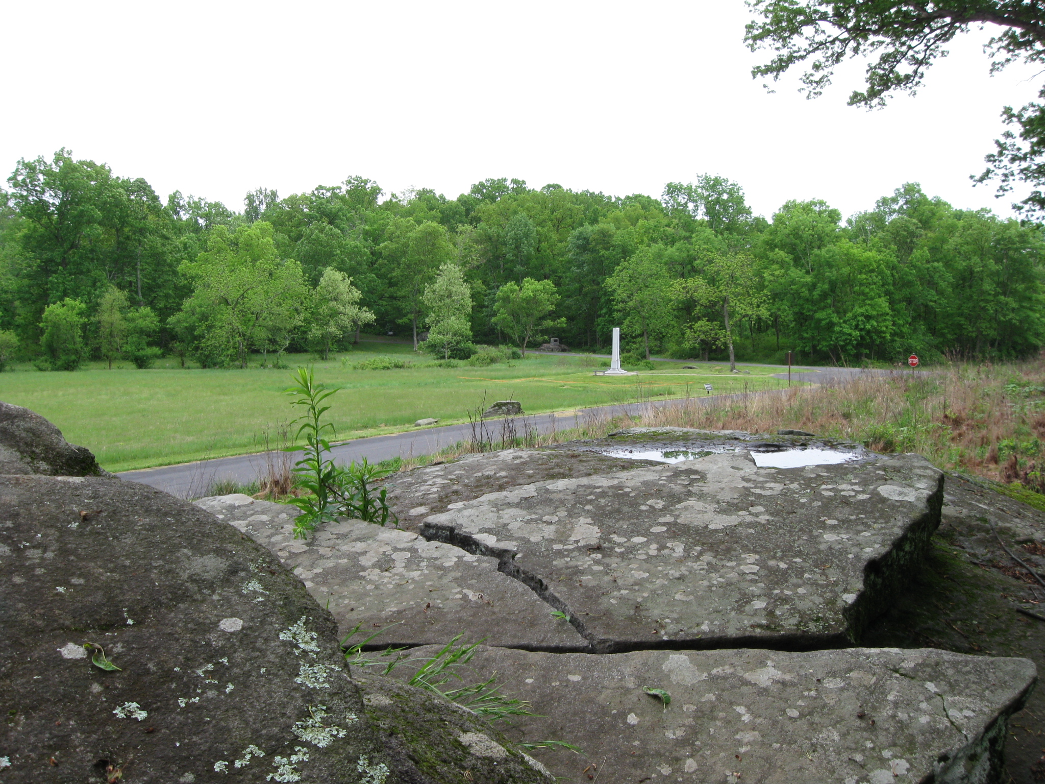
On the morning of July 3, 1863, United States troops attempted to take lower Culp’s Hill/Spangler’s Hill back from the Confederates who had captured it the previous evening. Their attack across Spangler’s Meadow was futile. Gettysburg Licensed Battlefield Guide Charlie Fennell is standing on the “Coble Rock,” occupied by Confederates the morning of July 3, 1863. Spangler’s Meadow is the low ground behind him. The Indiana State Monument is on the far left. The monument to the 1st Maryland Infantry, Potomac Home Brigade (USA) is to the right on lower Culp’s Hill/Spangler’s Hill. This view was taken facing southwest at approximately 9:30 AM on Sunday, May 17, 2009.
Our Culp’s Hill series is led by Gettysburg Licensed Battlefield Guide Dr. Charles Fennell. Dr. Fennell received his Ph.D. in history from the University of West Virginia in 1992. His dissertation was titled, “The Battle of Culp’s Hill.” In our first post on Culp’s Hill, he began our tour at the summit, near the observation tower. In our second post he continued his walk around Culp’s Hill by discussing the position of the 60th New York Infantry Regiment. In our third post he looked at the earthworks in the area of the monuments to the 150th New York Infantry Regiment and the 78th and 102nd New York Infantry Regiments. In our fourth post, Charlie showed us the monuments to the 149th and 137th New York Infantry Regiments, and discusses some of their actions. In our fifth post, Dr. Fennell showed us the 137th New York’s position on lower Culp’s Hill/Spangler’s Hill and the monument to the 2nd Maryland Infantry Regiment (CSA). In today’s post we look at the fighting at Spangler’s Meadow on the morning of July 3, 1863.
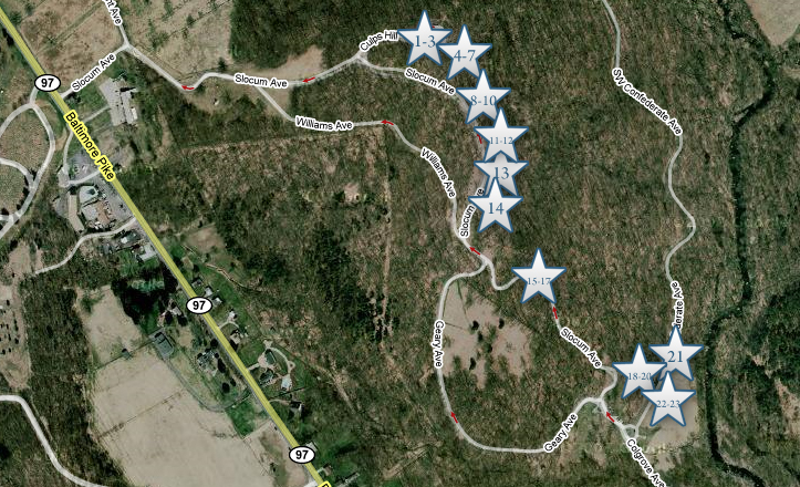
This map will show the locations of the videos we will show on the tour. Videos #1-#3 were taken on the summit of Culp’s Hill near the observation tower. Videos #4-#7 were taken near the monument to the 60th New York Infantry Regiment. Videos #8-#10 were taken between the monuments to the 150th New York and the 78th/102nd New York Infantry Regiments. Videos #11-#12 were taken by the monument to the 149th New York Infantry Regiment. Video #13 was taken near the monument to the 137th New York Infantry Regiment. Video #14 was taken near the marker for the 84th New York (14th Brooklyn) Infantry Regiment. Videos #15-#17 were taken on or near lower Culp’s Hill/Spangler’s Hill. Videos #s 18-20 were taken on the Coble Rock overlooking Spangler’s Meadow. Video #21 was taken at the Smith Brigade Marker on the north side of Spangler’s Meadow. Videos #s 22-23 were taken at the advance marker for the 27th Indiana Infantry regiment. This map was created facing north at approximately 10:30 PM on Saturday, June 6, 2009.
In Video #18 (Videos #s 1-17 were shown in the previous posts on Culp’s Hill), Charlie Fennell shows us Spangler’s Meadow from the Confederate point of view on lower Culp’s Hill, or Spangler’s Hill. This view was taken facing east to southwest at approximately 9:30 AM on Sunday, May 17, 2009.
In video #19, Dr. Fennell informs us how the battle of July 3, 1863 at Culp’s Hill begins. This view was taken facing southwest at approximately 9:30 AM on Sunday, May 17, 2009.
Charlie Fennell is pointing out the A. L. Coble (1st North Carolina Infantry) carving on the rock overlooking Spangler’s Meadow. This view was taken facing southwest at approximately 9:30 AM on Sunday, May 17, 2009.
In video #20, Dr. Fennell shows us the Coble rock carving, and the view that Coble would have had of Spangler’s Meadow. This view was taken facing southwest at approximately 9:30 AM on Sunday, May 17, 2009.
A closer view of Augustus Leonidas Coble’s rock carving. This view was taken facing southwest at approximately 9:30 AM on Sunday, May 17, 2009.
Here’s the view of Spangler’s Meadow that Augustus Leonidas Coble and other members of the 1st North Carolina Infantry Regiment had the morning of July 3, 1863. This view was taken facing southwest at approximately 9:30 AM on Sunday, May 17, 2009.
Charlie has now moved east of the Coble Rock to a position on the northeast side of Spangler’s Meadow. This view was taken facing southwest at approximately 9:30 AM on Sunday, May 17, 2009.
In video #21, Licensed Battlefield Guide Charlie Fennell explains how William “Extra Billy” Smith and his brigade arrived on the field and the charge made by the 49th Virginia. This view was taken facing southwest at approximately 9:30 AM on Sunday, May 17, 2009.
A view of the Smith Brigade marker. This view was taken facing southeast at approximately 4:45 PM on Tuesday, May 20, 2008.
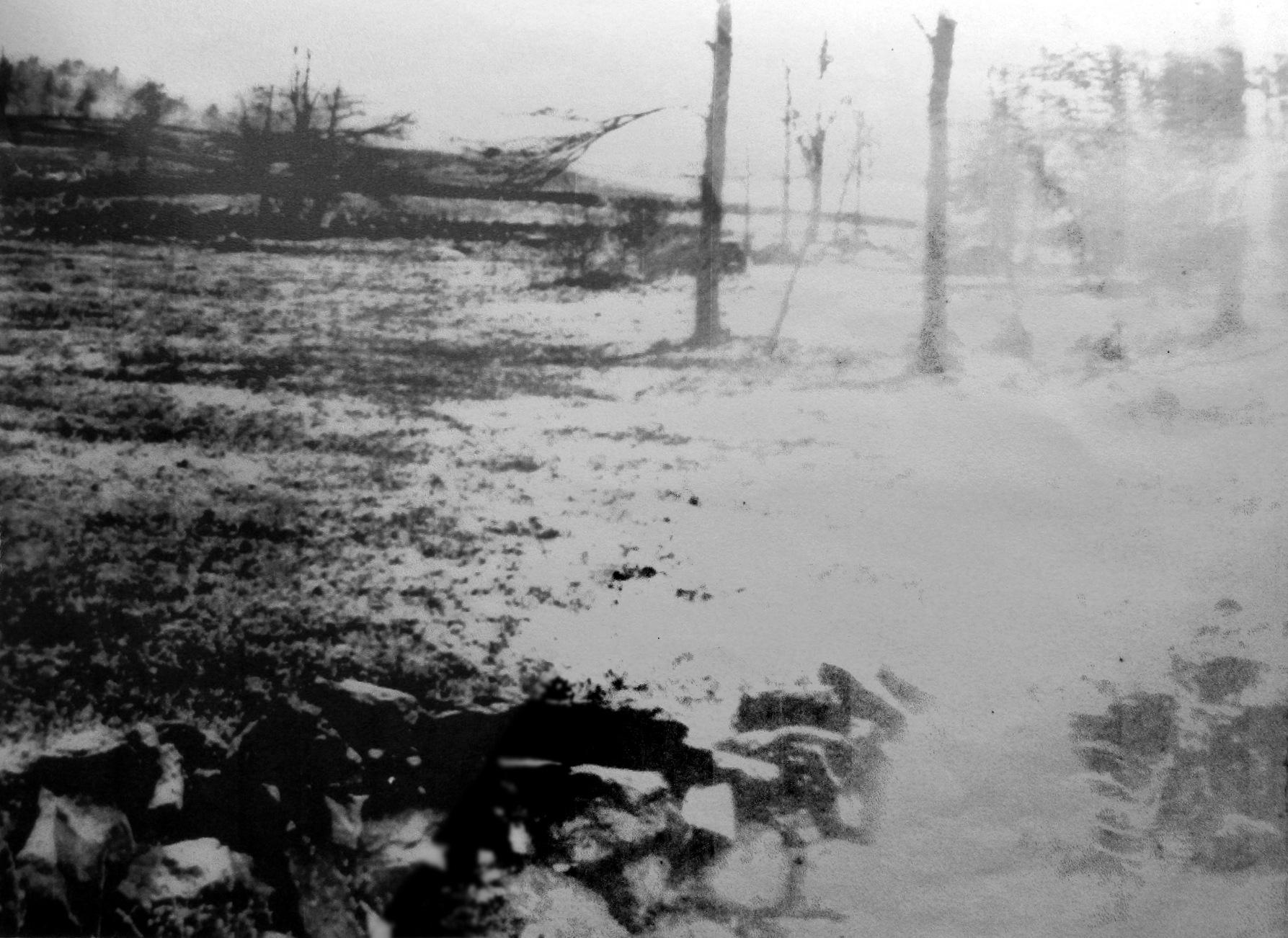
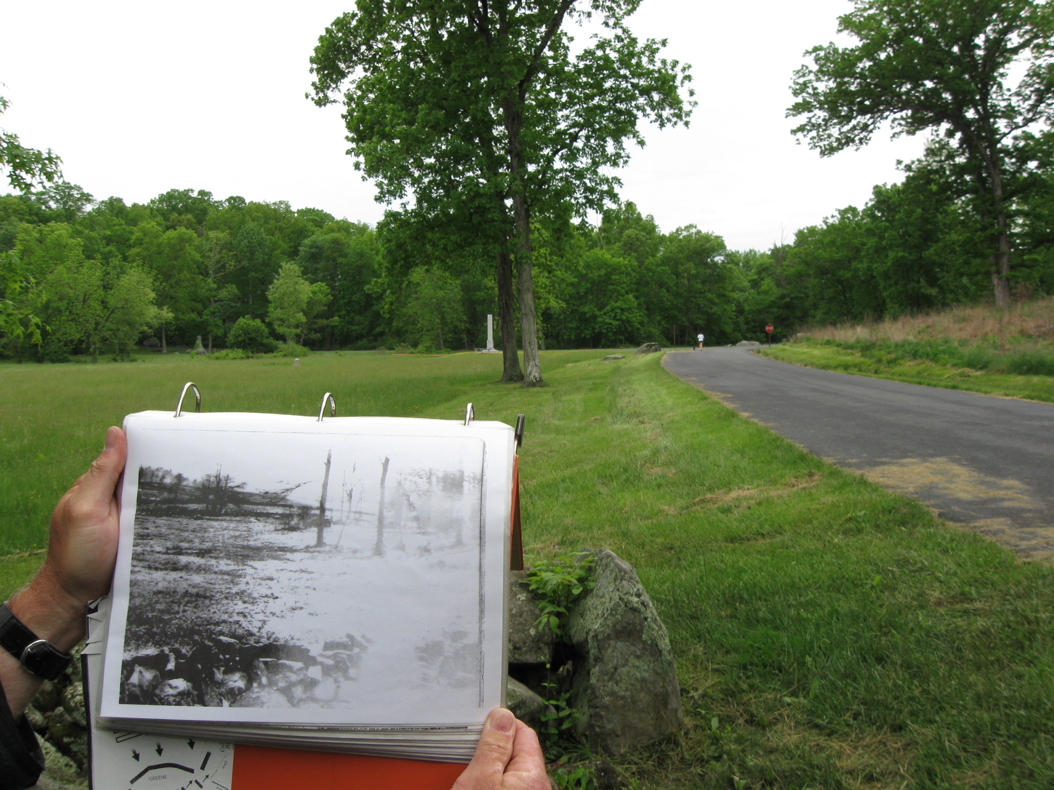
A photograph that Charlie has of Spangler’s Meadow before East Confederate Avenue was constructed. This view was taken facing southwest at approximately 9:30 AM on Sunday, May 17, 2009.
We are comparing Charlie’s photograph with how the area looks today. Notice the trees on the other (west) side of Spangler’s Meadow need to be cleared to match this historic photograph. This view was taken facing southwest at approximately 9:30 AM on Sunday, May 17, 2009.
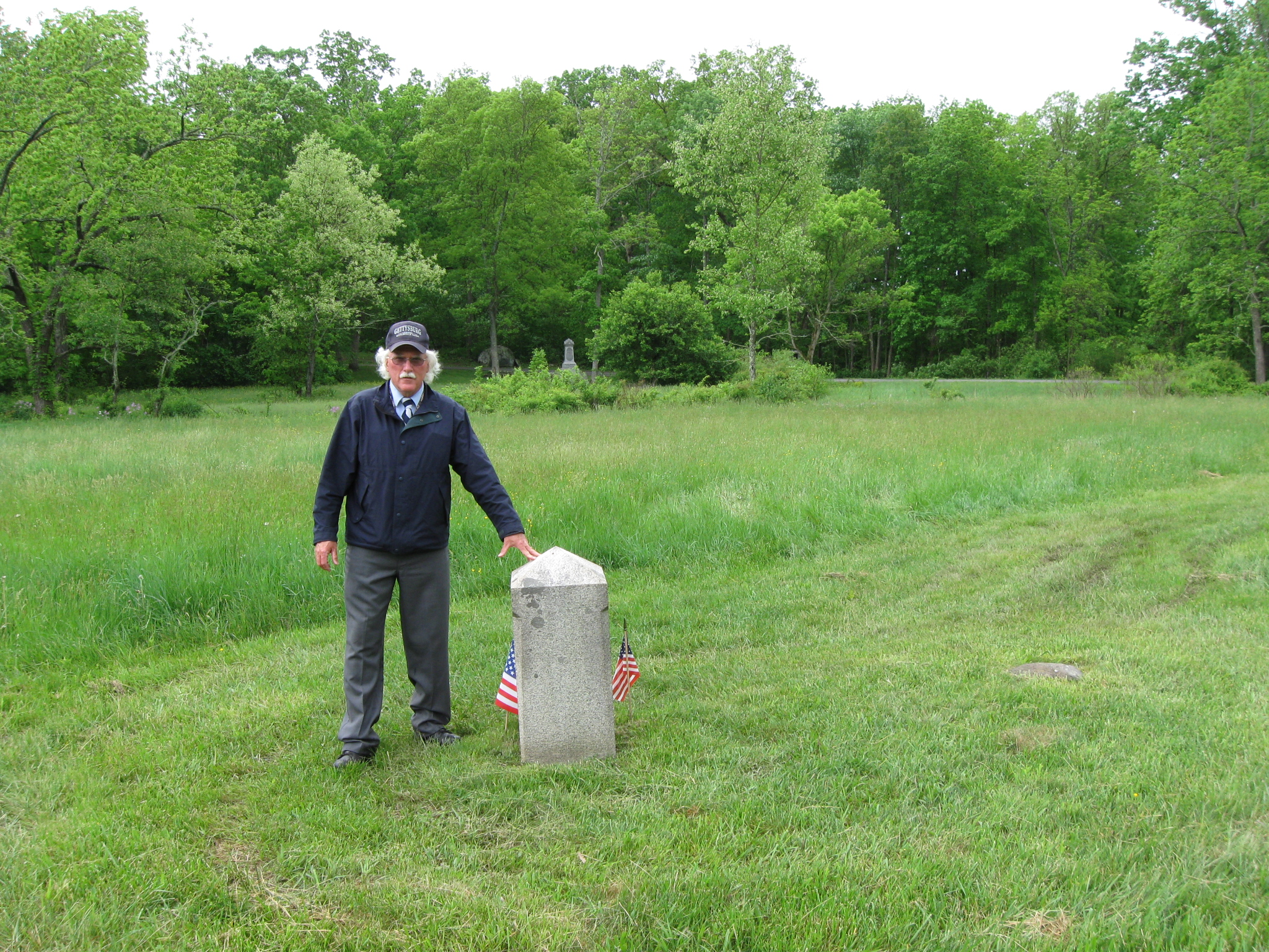
Dr. Fennell has now moved into Spangler’s Meadow to the advance marker of the 27th Indiana Infantry Regiment. McAllister’s Woods and the 27th Indiana Monument are in the background. This view was taken facing southwest at approximately 9:30 AM on Sunday, May 17, 2009.
In video #22, Dr. Charles Fennell shows us the 27th Indiana advance marker and its relationship with the Indiana State Monument and the 27th Indiana Monument. This view was taken facing southwest to northeast at approximately 9:30 AM on Sunday, May 17, 2009.
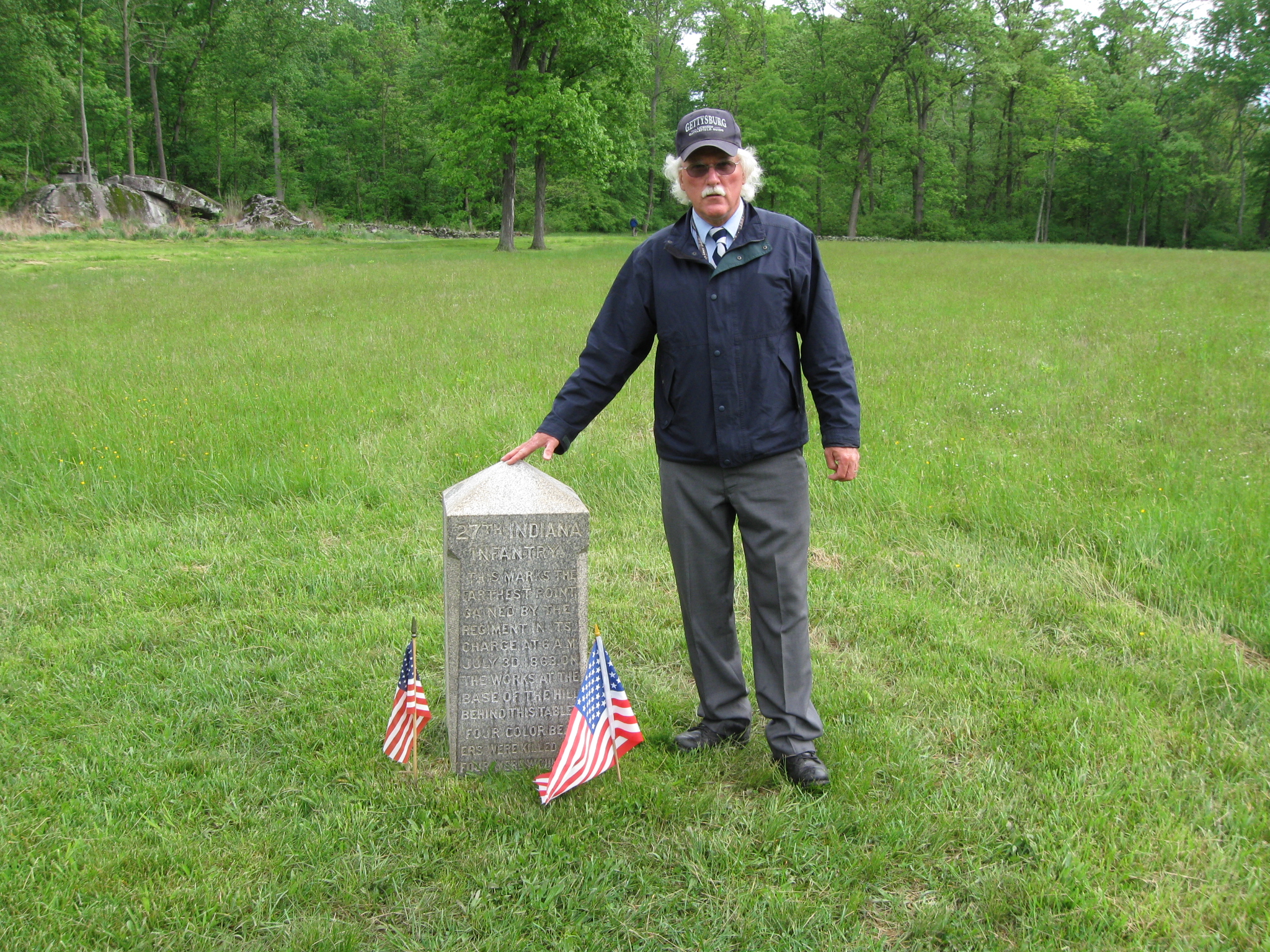
Another view of the 27th Indiana advance marker. The Coble rock is in the left background. The stone wall marking the position of Extra Billy Smith’s Brigade is in the right background along the treeline. This view was taken facing northeast at approximately 9:30 AM on Sunday, May 17, 2009.
In video #23, Charlie shows us the 27th Indiana advance marker and its relationship with the Confederate defenders. He also tells the story of Captain David Van Buskirk. This view was taken facing northeast at approximately 9:30 AM on Sunday, May 17, 2009.
To see other posts by Gettysburg Licensed Battlefield Guides, click here.