

A two story version of the Brian/Bryan House is in the curve of Hancock Avenue. The cannon mark the position occupied by the 9th Massachusetts Battery. Ziegler’s Grove is being replanted. The Ziegler’s Grove Tower dominates the scene. The Annual Report of the Gettysburg National Military Park Commission to the Secretary of War in 1896 states: “Since our report of 1895 the Telford road, known as Seminary avenue, and section 1 of Confederate avenue, running from the Chambersburg pike southward along Seminary Ridge as far as the Government at present owns the right of way there, has been completed; likewise Hancock Avenue which runs from the national cemetery gate southward along the main Union line of battle to the east end of United States avenue…” (page 29) “The four steel towers which were in course of construction at the date of our last report were completed soon thereafter. We have since caused another to be erected near the center of the field in Ziegler’s Grove and not far from the point where the battle ended with the final grand but unsuccessful Confederate assault of the third day. These are all solid and well-built structures, and located as they are, they afford the observer a complete and satisfactory view of the entire scene of the great battle and enable him to get a consistent and accurate idea of it as a whole.” (page 31) This view was taken facing south circa 1896. Annual Reports of the Gettysburg National Military Park Commission to the Secretary of War, 1893-1904. Washington. Government Printing Office, 1905.
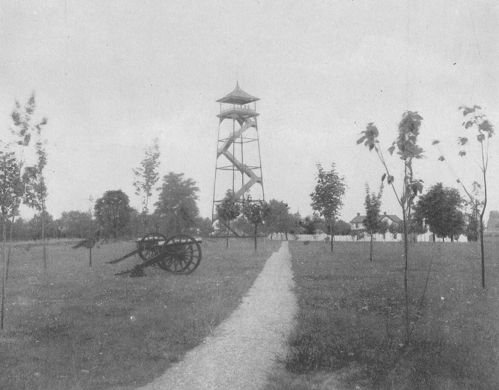
This image is titled, “A Walk Through Ziegler’s Grove Showing Butler’s Second United States Battery G.” At one time there were five observation towers at Gettysburg National Military Park. Tower #1 was 60 feet tall and was located on Big Round Top. Tower #2 is 75 feet tall and is located on Seminary Ridge. It is known as the Longstreet Tower. Tower #3 used to be 75 feet tall until it was cut down to its current size. It is the Oak Ridge Tower near the Mummasburg Road. Tower #4 is 60 feet tall and is located on Culp’s Hill. The first four towers were constructed in 1895. The Ziegler’s Grove Tower was constructed in 1896, and must have been known as Tower #5. We do not know if it was 60 feet tall or 75 feet tall. When General Pershing climbed it in July, 1922, he was 61 years old. When then Major General Lejeune climbed it he was 55 years old. In this photograph, Ziegler’s Grove had recently been replanted. The Bryan/Brian House is behind the white picket fence. The cannon closest to the path mark the position occupied by John H. Butler’s Battery G, 2nd United States Artillery. The monument on the far right of the photograph is to the 108th New York Infantry Regiment. This view was taken facing southwest circa 1896. Annual Reports of the Gettysburg National Military Park Commission to the Secretary of War, 1893-1904. Washington. Government Printing Office, 1905.
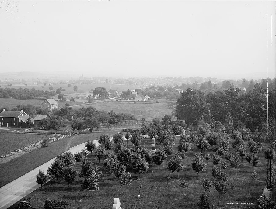
This image is titled, “016576 Gettysburg From Cemetery Ridge, Gettysburg, PA.” It was taken from the top of the Ziegler’s Grove Observation Tower looking northward to the town of Gettysburg. In the bottom left of the photograph is an artillery piece marking the location of the 9th Massachusetts Battery on July 3, 1863. At the bottom of the photograph is the top of the monument to the 108th New York Infantry Regiment. Notice the trees recently planted in Ziegler’s Grove. The monument most clearly seen in the grove is to the 126th New York Infantry Regiment. Also visible through the grove is the monument to the 90th Pennsylvania Infantry Regiment. Notice the pathway through Ziegler’s Grove in the bottom right of the photograph leading away from the tower. The road on the left is Hancock Avenue. Parallel with Hancock Avenue, including the curve is the electric trolley line. This view by the Detroit Publishing Company was taken facing northwest circa 1900-1906. It is part of the Detroit Publishing Company Photograph Collection in the Library of Congress Prints and Photographs Division Washington, D.C. 20540 USA. The reproduction number is LC-D4-16576. The Call number is LC-D4-16576.
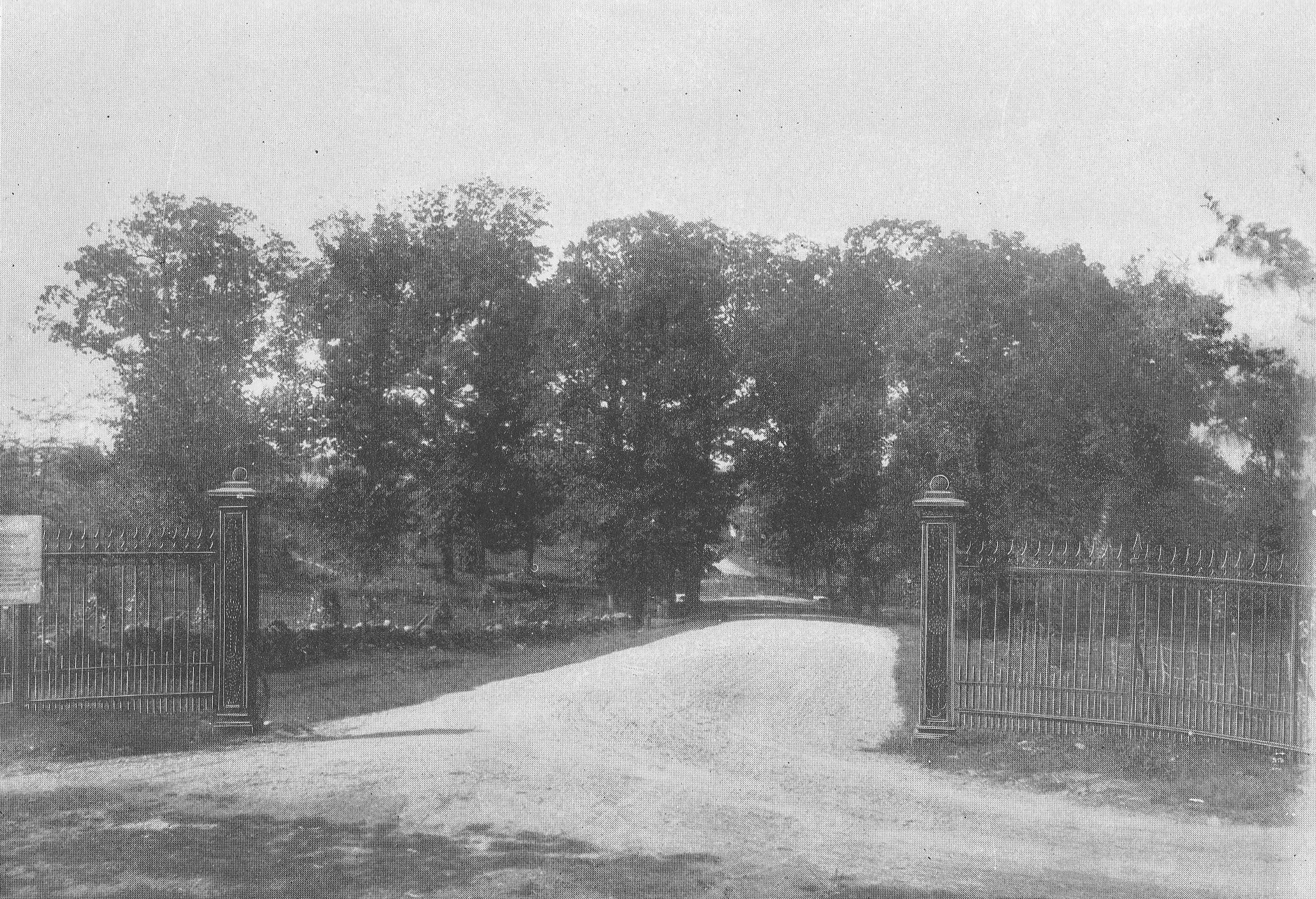
This image is titled, “Entrance to Hancock Avenue, Ziegler’s Grove.” The Annual Report of the Gettysburg National Military Park Commission to the Secretary of War in 1896 states: “Since our report of 1895 the Telford road, known as Seminary avenue, and section 1 of Confederate avenue, running from the Chambersburg pike southward along Seminary Ridge as far as the Government at present owns the right of way there, has been completed; likewise Hancock Avenue which runs from the national cemetery gate southward along the main Union line of battle to the east end of United States avenue…” (page 29) The Taneytown Road is running from left to right in the foreground. In the left background is now the “old Cyclorama” parking lot/National Cemetery parking lot. This view was taken facing west circa 1896. Annual Reports of the Gettysburg National Military Park Commission to the Secretary of War, 1893-1904. Washington. Government Printing Office, 1905.

This image is titled “Grove South of Wheat Field, After September 30, 1896.” The location is an unknown location in Rose’s Woods. The 1896 commission report states: “We have also caused great numbers of trees to be planted, so as to restore the forest on grounds which have been denuded of trees since the battle. The hurricane of last month destroyed many hundreds of trees on the battlefield, which we shall take measures to replace.” (Gettysburg National Military Park Commission Report page 39) “The Fury of the Storm. The most devastating storm that every visited this community fell upon us on last Tuesday night with the fury of a hurricane, unroofing buildings, twisting off and uprooting trees and laying fences flat. The greatest damage done here was in the northern part of the town…. Numbers of trees damaged on the Battlefield: Reynolds’ Grove… 12 Blown over, 31 Broken Off and will have to be cut down. Schultz’s Grove… 0 Blown over, 1 Broken Off and will have to be cut down. Ziegler’s Grove… 0 Blown over, 1 Broken Off and will have to be cut down. Culp’s Hill… 120 Blown over, 93 Broken Off and will have to be cut down. McAllister’s Woods… 1 Blown over, 0 Broken Off and will have to be cut down. Round Top Park… 32 Blown over, 40 Broken Off and will have to be cut down. Little Round Top… 41 Blown over, 51 Broken Off and will have to be cut down. Big Round Top… 135 Blown over, 99 Broken Off and will have to be cut down. Between Round Tops… 38 Blown over, 0 Broken Off and will have to be cut down. Along Sickles Avenue 54 Blown over, 26 Broken Off and will have to be cut down. Bushman Woods… 48 Blown over, 44 Broken Off and will have to be cut down. Along Confederate Avenue… 13 Blown over, 4 Broken Off and will have to be cut down. (Editor’s Note: The total of trees blown over was 494. The total of trees that were broken off and will have to be cut down was 390 or a total of 884 trees that were blown down or had to be removed). Roof blown off tower at the Bryan House. Piece of roof off tower at Starner’s. The monument of the 66th Ohio Regiment, on Culp’s Hill, was ruined by huge trees which fell upon it. The monuments of the 102d and Seventy-eighth New York Regiment were slightly injured, but can be repaired. The fine avenue of Norway maple trees in the National Cemetery was nearly destroyed, many of the largest limbs having been torn off. (Gettysburg Star and Sentinel October 6, 1896, page 3, column 4) This image was taken in an unknown location circa 1896. Annual Reports of the Gettysburg National Military Park Commission to the Secretary of War, 1893-1904. Washington. Government Printing Office, 1905.
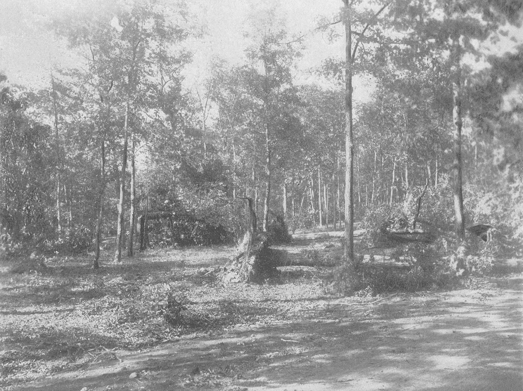
This image is titled “Grove South of Wheat Field, After Storm of September 30, 1896.” The location is an unknown location in Rose’s Woods. The 1896 commission report states: “We have also caused great numbers of trees to be planted, so as to restore the forest on grounds which have been denuded of trees since the battle. The hurricane of last month destroyed many hundreds of trees on the battlefield, which we shall take measures to replace.” (Gettysburg National Military Park Commission Report page 39) “The Fury of the Storm. The most devastating storm that every visited this community fell upon us on last Tuesday night with the fury of a hurricane, unroofing buildings, twisting off and uprooting trees and laying fences flat. The greatest damage done here was in the northern part of the town…. Numbers of trees damaged on the Battlefield: Reynolds’ Grove… 12 Blown over, 31 Broken Off and will have to be cut down. Schultz’s Grove… 0 Blown over, 1 Broken Off and will have to be cut down. Ziegler’s Grove… 0 Blown over, 1 Broken Off and will have to be cut down. Culp’s Hill… 120 Blown over, 93 Broken Off and will have to be cut down. McAllister’s Woods… 1 Blown over, 0 Broken Off and will have to be cut down. Round Top Park… 32 Blown over, 40 Broken Off and will have to be cut down. Little Round Top… 41 Blown over, 51 Broken Off and will have to be cut down. Big Round Top… 135 Blown over, 99 Broken Off and will have to be cut down. Between Round Tops… 38 Blown over, 0 Broken Off and will have to be cut down. Along Sickles Avenue 54 Blown over, 26 Broken Off and will have to be cut down. Bushman Woods… 48 Blown over, 44 Broken Off and will have to be cut down. Along Confederate Avenue… 13 Blown over, 4 Broken Off and will have to be cut down. (Editor’s Note: The total of trees blown over was 494. The total of trees that were broken off and will have to be cut down was 390 or a total of 884 trees that were blown down or had to be removed). Roof blown off tower at the Bryan House. Piece of roof off tower at Starner’s. The monument of the 66th Ohio Regiment, on Culp’s Hill, was ruined by huge trees which fell upon it. The monuments of the 102d and Seventy-eighth New York Regiment were slightly injured, but can be repaired. The fine avenue of Norway maple trees in the National Cemetery was nearly destroyed, many of the largest limbs having been torn off. (Gettysburg Star and Sentinel October 6, 1896, page 3, column 4) This image was taken in an unknown location circa 1896. Annual Reports of the Gettysburg National Military Park Commission to the Secretary of War, 1893-1904. Washington. Government Printing Office, 1905.