
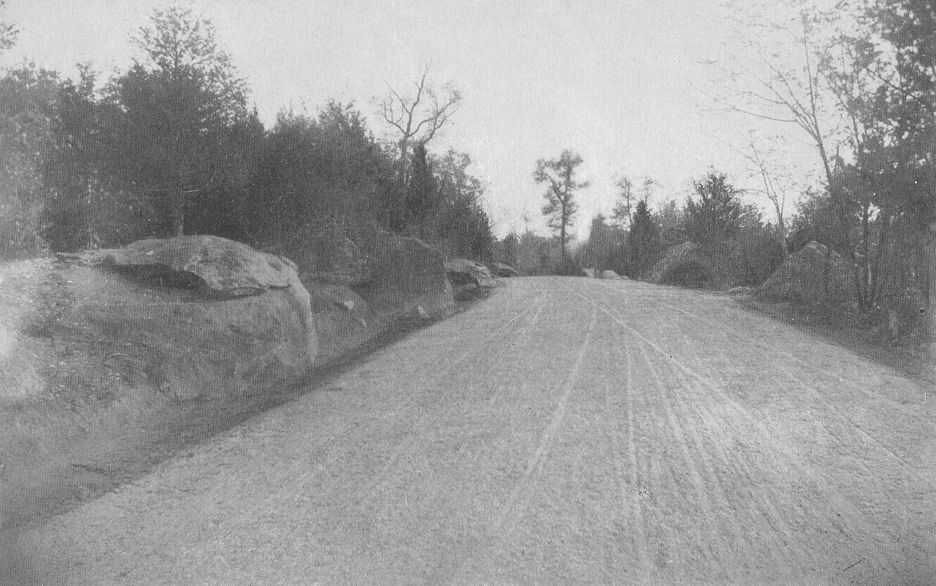
This image is titled “A View of Section 7, Confederate Avenue. Looking south from near the entrance of Kilpatrick Avenue.” The location is on the southwest slope of Big Round Top. The image is looking southeast. This part of South Confederate Avenue is no longer in use. The 1895 commission report states, “At the date when our report as the Battlefield Commission was made last year the only roadway in process of construction was section 4 of the Confederate avenue, from the Wheatfield road to the Emmitsburg road along Seminary Ridge. During the present year there have been constructed sections 5, 6, and 7 of Confederate avenue extending south from the Emmitsburg road to the southern limits of the battlefield, thence eastward crossing Plum Run, and up along the west slope of Round Top to Kilpatrick avenue… All these avenues have been and are being constructed on the Telford system, which was adopted after full consideration and study of the subject as promising the best results in solidity and durability. The stone used is syenitic granite and ironstone, very hard and of excellent quality. A foundation pavement is laid of 8-inch wedgelike stones set on edge and well knapped and chinked; on this 4 inches of stone 1 1/2 inches in size; then a slight layer of clay as a binder, and finally a top dressing of 1 or 2 inches of quarter-inch stone screenings; the whole rolled thoroughly with a steam roller weighing 14 tons; side and under drains are placed where needed. The results of the above method and process are roadways smooth and solid and which will last for generations.” (page 21) This view was taken possibly facing north circa 1895. Annual Reports of the Gettysburg National Military Park Commission to the Secretary of War, 1893-1904. Washington. Government Printing Office, 1905.
One of our favorite parts about running Gettysburg Daily has been making available images and documents to the public. It is a strong belief of ours that historic photographs and images should be freely accessible to all. Today we’re presenting you a preview of the Big Round Top “sources” pages that we’ll be adding to the site in the coming months.
To see previous resources posts:
Seminary Ridge Resources
East Cemetery Hill Resources
Slocum Avenue Resources
Cemetery Ridge Resources
To see previous posts on Big Round Top:
Climbing Big Round Top, on January 7, 2011.
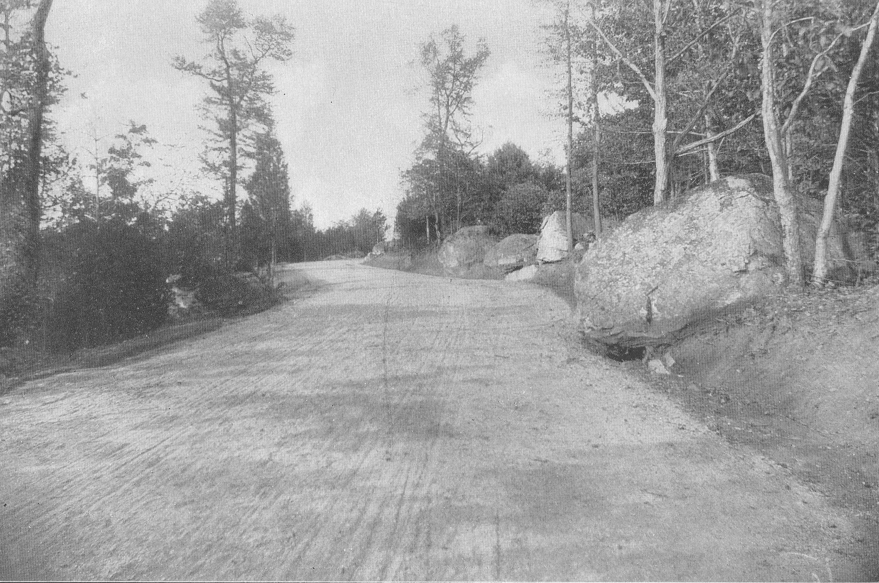
This image is titled “A View of Confederate Avenue, Section 7, Looking North.” The location is on the southwest slope of Big Round Top. The image is looking northwest. This part of South Confederate Avenue is no longer in use. The 1895 commission report states, “At the date when our report as the Battlefield Commission was made last year the only roadway in process of construction was section 4 of the Confederate avenue, from the Wheatfield road to the Emmitsburg road along Seminary Ridge. During the present year there have been constructed sections 5, 6, and 7 of Confederate avenue extending south from the Emmitsburg road to the southern limits of the battlefield, thence eastward crossing Plum Run, and up along the west slope of Round Top to Kilpatrick avenue… All these avenues have been and are being constructed on the Telford system, which was adopted after full consideration and study of the subject as promising the best results in solidity and durability. The stone used is syenitic granite and ironstone, very hard and of excellent quality. A foundation pavement is laid of 8-inch wedgelike stones set on edge and well knapped and chinked; on this 4 inches of stone 1 1/2 inches in size; then a slight layer of clay as a binder, and finally a top dressing of 1 or 2 inches of quarter-inch stone screenings; the whole rolled thoroughly with a steam roller weighing 14 tons; side and under drains are placed where needed. The results of the above method and process are roadways smooth and solid and which will last for generations.” (page 21) This view was taken possibly facing north circa 1895. Annual Reports of the Gettysburg National Military Park Commission to the Secretary of War, 1893-1904. Washington. Government Printing Office, 1905.

This image is titled “Big Round Top, Near Tower, After Storm of September 30, 1896.” The location is the top of Big Round Top. The Big Round Top observation tower is visible through the trees in the left background. The 1896 commission report states: “We have also caused great numbers of trees to be planted, so as to restore the forest on grounds which have been denuded of trees since the battle. The hurricane of last month destroyed many hundreds of trees on the battlefield, which we shall take measures to replace.” (Gettysburg National Military Park Commission Report page 39) “The Fury of the Storm. The most devastating storm that every visited this community fell upon us on last Tuesday night with the fury of a hurricane, unroofing buildings, twisting off and uprooting trees and laying fences flat. The greatest damage done here was in the northern part of the town…. Numbers of trees damaged on the Battlefield: Reynolds’ Grove… 12 Blown over, 31 Broken Off and will have to be cut down. Schultz’s Grove… 0 Blown over, 1 Broken Off and will have to be cut down. Ziegler’s Grove… 0 Blown over, 1 Broken Off and will have to be cut down. Culp’s Hill… 120 Blown over, 93 Broken Off and will have to be cut down. McAllister’s Woods… 1 Blown over, 0 Broken Off and will have to be cut down. Round Top Park… 32 Blown over, 40 Broken Off and will have to be cut down. Little Round Top… 41 Blown over, 51 Broken Off and will have to be cut down. Big Round Top… 135 Blown over, 99 Broken Off and will have to be cut down. Between Round Tops… 38 Blown over, 0 Broken Off and will have to be cut down. Along Sickles Avenue 54 Blown over, 26 Broken Off and will have to be cut down. Bushman Woods… 48 Blown over, 44 Broken Off and will have to be cut down. Along Confederate Avenue… 13 Blown over, 4 Broken Off and will have to be cut down. (Editor’s Note: The total of trees blown over was 494. The total of trees that were broken off and will have to be cut down was 390 or a total of 884 trees that were blown down or had to be removed). Roof blown off tower at the Bryan House. Piece of roof off tower at Starner’s. The monument of the 66th Ohio Regiment, on Culp’s Hill, was ruined by huge trees which fell upon it. The monuments of the 102d and Seventy-eighth New York Regiment were slightly injured, but can be repaired. The fine avenue of Norway maple trees in the National Cemetery was nearly destroyed, many of the largest limbs having been torn off. (Gettysburg Star and Sentinel October 6, 1896, page 3, column 4) This image was taken facing southeast circa 1896. Annual Reports of the Gettysburg National Military Park Commission to the Secretary of War, 1893-1904. Washington. Government Printing Office, 1905.

This image is titled “Big Round Top, After Storm of September 30, 1896.” The location is the top of Big Round Top. The monument to the 20th Maine Infantry Regiment is visible through the trees in the left background. The 1896 commission report states: “We have also caused great numbers of trees to be planted, so as to restore the forest on grounds which have been denuded of trees since the battle. The hurricane of last month destroyed many hundreds of trees on the battlefield, which we shall take measures to replace.” (Gettysburg National Military Park Commission Report page 39) “The Fury of the Storm. The most devastating storm that every visited this community fell upon us on last Tuesday night with the fury of a hurricane, unroofing buildings, twisting off and uprooting trees and laying fences flat. The greatest damage done here was in the northern part of the town…. Numbers of trees damaged on the Battlefield: Reynolds’ Grove… 12 Blown over, 31 Broken Off and will have to be cut down. Schultz’s Grove… 0 Blown over, 1 Broken Off and will have to be cut down. Ziegler’s Grove… 0 Blown over, 1 Broken Off and will have to be cut down. Culp’s Hill… 120 Blown over, 93 Broken Off and will have to be cut down. McAllister’s Woods… 1 Blown over, 0 Broken Off and will have to be cut down. Round Top Park… 32 Blown over, 40 Broken Off and will have to be cut down. Little Round Top… 41 Blown over, 51 Broken Off and will have to be cut down. Big Round Top… 135 Blown over, 99 Broken Off and will have to be cut down. Between Round Tops… 38 Blown over, 0 Broken Off and will have to be cut down. Along Sickles Avenue 54 Blown over, 26 Broken Off and will have to be cut down. Bushman Woods… 48 Blown over, 44 Broken Off and will have to be cut down. Along Confederate Avenue… 13 Blown over, 4 Broken Off and will have to be cut down. (Editor’s Note: The total of trees blown over was 494. The total of trees that were broken off and will have to be cut down was 390 or a total of 884 trees that were blown down or had to be removed). Roof blown off tower at the Bryan House. Piece of roof off tower at Starner’s. The monument of the 66th Ohio Regiment, on Culp’s Hill, was ruined by huge trees which fell upon it. The monuments of the 102d and Seventy-eighth New York Regiment were slightly injured, but can be repaired. The fine avenue of Norway maple trees in the National Cemetery was nearly destroyed, many of the largest limbs having been torn off. (Gettysburg Star and Sentinel October 6, 1896, page 3, column 4) This image was taken facing northeast circa 1896. Annual Reports of the Gettysburg National Military Park Commission to the Secretary of War, 1893-1904. Washington. Government Printing Office, 1905.

This image is titled “Big Round Top, After Storm of September 30, 1896.” The location is the top of Big Round Top. The 1896 commission report states: “We have also caused great numbers of trees to be planted, so as to restore the forest on grounds which have been denuded of trees since the battle. The hurricane of last month destroyed many hundreds of trees on the battlefield, which we shall take measures to replace.” (Gettysburg National Military Park Commission Report page 39) “The Fury of the Storm. The most devastating storm that every visited this community fell upon us on last Tuesday night with the fury of a hurricane, unroofing buildings, twisting off and uprooting trees and laying fences flat. The greatest damage done here was in the northern part of the town…. Numbers of trees damaged on the Battlefield: Reynolds’ Grove… 12 Blown over, 31 Broken Off and will have to be cut down. Schultz’s Grove… 0 Blown over, 1 Broken Off and will have to be cut down. Ziegler’s Grove… 0 Blown over, 1 Broken Off and will have to be cut down. Culp’s Hill… 120 Blown over, 93 Broken Off and will have to be cut down. McAllister’s Woods… 1 Blown over, 0 Broken Off and will have to be cut down. Round Top Park… 32 Blown over, 40 Broken Off and will have to be cut down. Little Round Top… 41 Blown over, 51 Broken Off and will have to be cut down. Big Round Top… 135 Blown over, 99 Broken Off and will have to be cut down. Between Round Tops… 38 Blown over, 0 Broken Off and will have to be cut down. Along Sickles Avenue 54 Blown over, 26 Broken Off and will have to be cut down. Bushman Woods… 48 Blown over, 44 Broken Off and will have to be cut down. Along Confederate Avenue… 13 Blown over, 4 Broken Off and will have to be cut down. (Editor’s Note: The total of trees blown over was 494. The total of trees that were broken off and will have to be cut down was 390 or a total of 884 trees that were blown down or had to be removed). Roof blown off tower at the Bryan House. Piece of roof off tower at Starner’s. The monument of the 66th Ohio Regiment, on Culp’s Hill, was ruined by huge trees which fell upon it. The monuments of the 102d and Seventy-eighth New York Regiment were slightly injured, but can be repaired. The fine avenue of Norway maple trees in the National Cemetery was nearly destroyed, many of the largest limbs having been torn off. (Gettysburg Star and Sentinel October 6, 1896, page 3, column 4) This image was taken facing northwest circa 1896. Annual Reports of the Gettysburg National Military Park Commission to the Secretary of War, 1893-1904. Washington. Government Printing Office, 1905.