
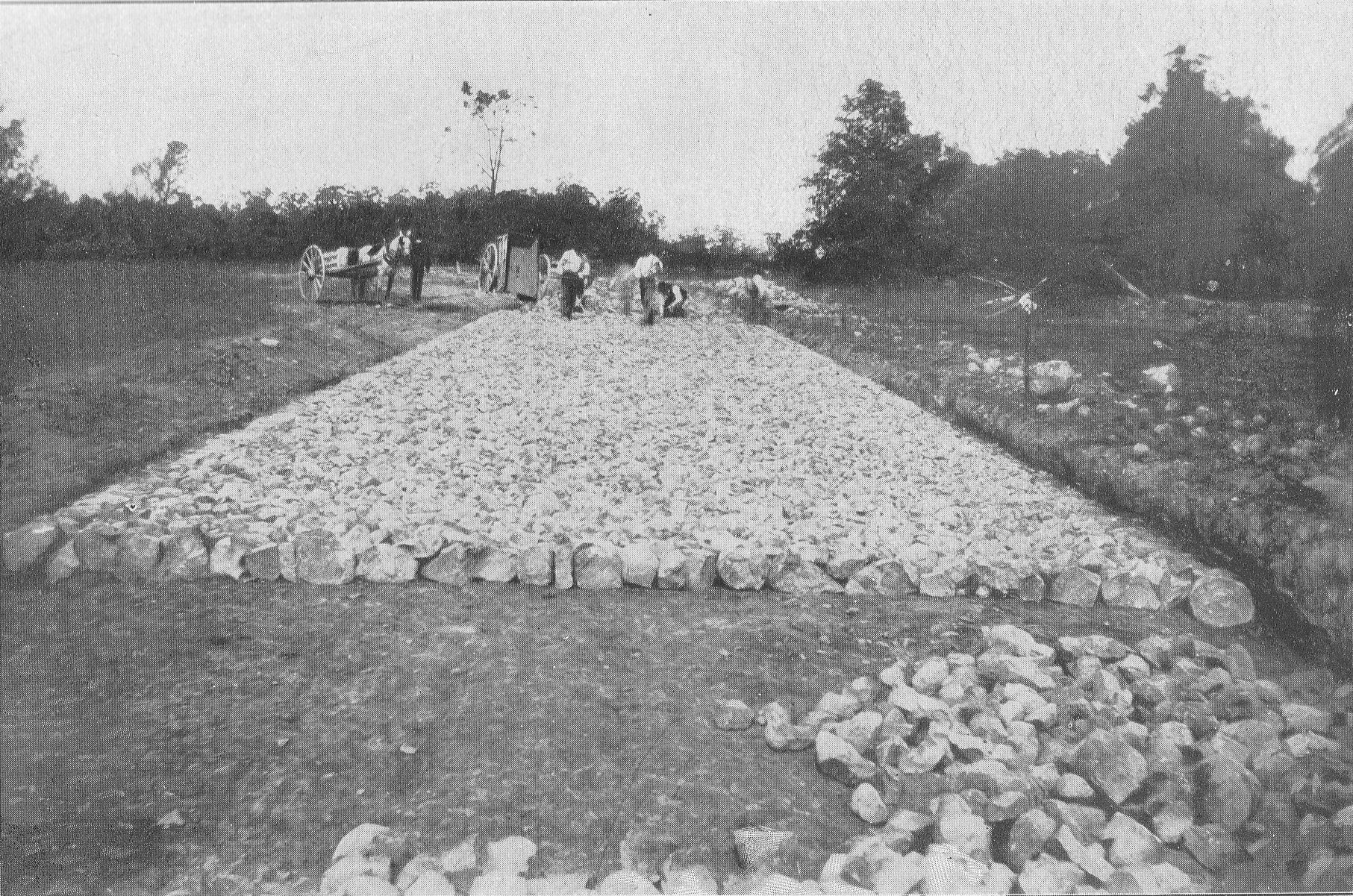
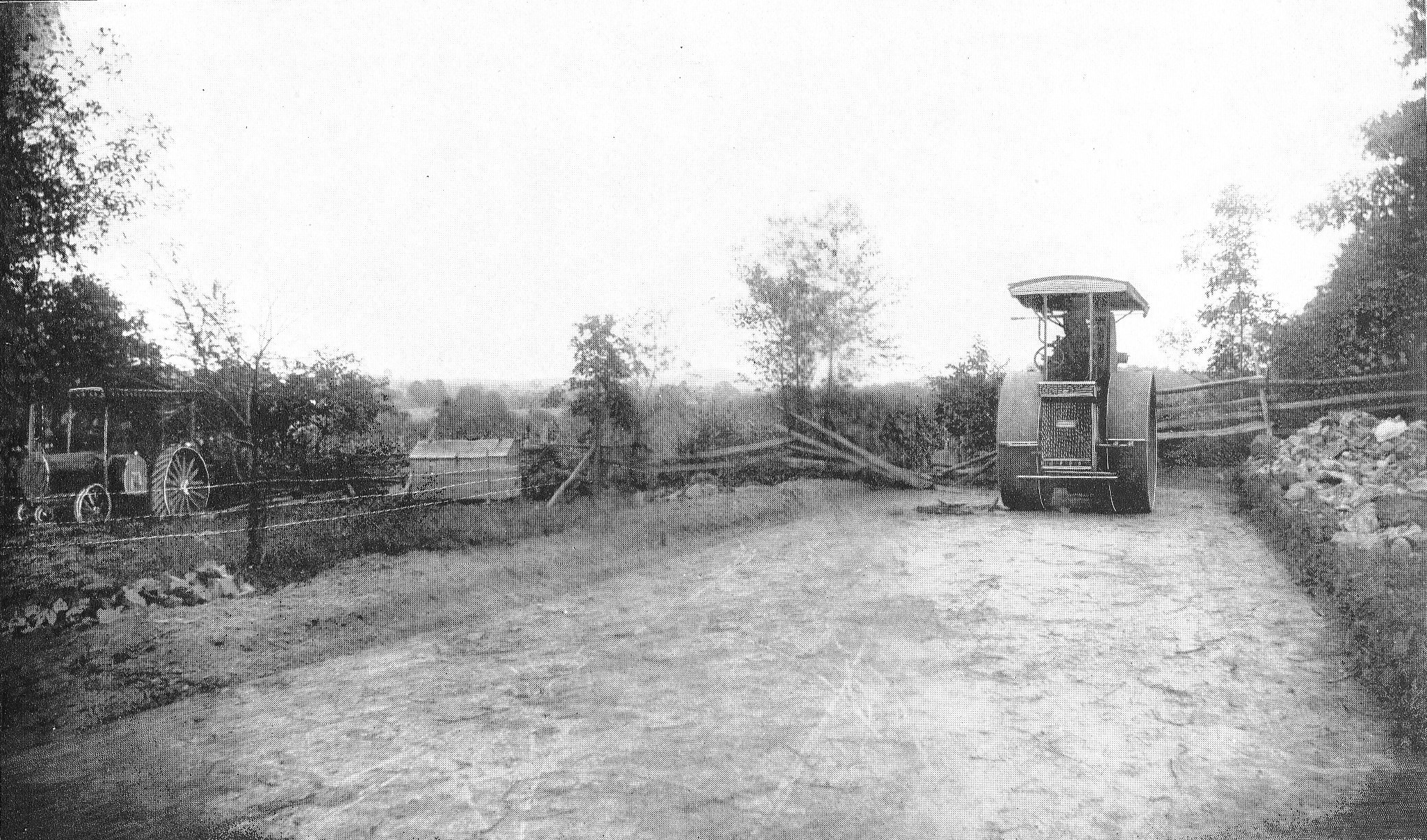
This image is titled “Laying Foundation Stone on Section 4 Confederate Avenue.” The location is West Confederate Avenue on Seminary Ridge. The Longstreet Tower has not yet been constructed and would be on the left, or just out of sight on the left. Section 4 of Confederate Avenue went from “Wheatfield Road to Emmitsburg road, 3700 feet.” The 1894 commission report states: “From the 13th to 21st of April a majority of those having received specifications for section 4 of the avenue for the purpose of viewing the locality, and were taken over the ground, and on the 21st five bids were handed in, namely Slayor & Boyer, Harrisburg, Pa.; B.B. Gonder, Strausburg, Pa.; Farrell & Bro., Westchester, Pa.; Richard W. Johnson, Wayne, Pa., and P. McManus, Philadelphia, Pa.” (pages 14-15; Editors note: the commission report did not say who got the bid). The 1895 commission report states, “At the date when our report as the Battlefield Commission was made last year the only roadway in process of construction was section 4 of the Confederate avenue, from the Wheatfield road to the Emmitsburg road along Seminary Ridge… All these avenues have been and are being constructed on the Telford system, which was adopted after full consideration and study of the subject as promising the best results in solidity and durability. The stone used is syenitic granite and ironstone, very hard and of excellent quality. A foundation pavement is laid of 8-inch wedgelike stones set on edge and well knapped and chinked; on this 4 inches of stone 1 1/2 inches in size; then a slight layer of clay as a binder, and finally a top dressing of 1 or 2 inches of quarter-inch stone screenings; the whole rolled thoroughly with a steam roller weighing 14 tons; side and under drains are placed where needed. The results of the above method and process are roadways smooth and solid and which will last for generations.” (page 21) This view was taken facing southeast circa 1894. Annual Reports of the Gettysburg National Military Park Commission to the Secretary of War, 1893-1904. Washington. Government Printing Office, 1905.
One of our favorite parts about running Gettysburg Daily has been making available images and documents to the public. It is a strong belief of ours that historic photographs and images should be freely accessible to all. Today we’re presenting you a preview of these “sources” pages that we’ll be adding to the site in the coming months.
This image is titled “Cross Section Foundation Pavement, Section 4 Confederate Avenue.” The location is West Confederate Avenue on Seminary Ridge. Section 4 of Confederate Avenue went from “Wheatfield Road to Emmitsburg road, 3700 feet.” The 1894 commission report states: “From the 13th to 21st of April a majority of those having received specifications for section 4 of the avenue for the purpose of viewing the locality, and were taken over the ground, and on the 21st five bids were handed in, namely Slayor & Boyer, Harrisburg, Pa.; B.B. Gonder, Strausburg, Pa.; Farrell & Bro., Westchester, Pa.; Richard W. Johnson, Wayne, Pa., and P. McManus, Philadelphia, Pa.” (pages 14-15 Editors Note: The commission report did not say who got the bid). The 1895 commission report states, “At the date when our report as the Battlefield Commission was made last year the only roadway in process of construction was section 4 of the Confederate avenue, from the Wheatfield road to the Emmitsburg road along Seminary Ridge… All these avenues have been and are being constructed on the Telford system, which was adopted after full consideration and study of the subject as promising the best results in solidity and durability. The stone used is syenitic granite and ironstone, very hard and of excellent quality. A foundation pavement is laid of 8-inch wedgelike stones set on edge and well knapped and chinked; on this 4 inches of stone 1 1/2 inches in size; then a slight layer of clay as a binder, and finally a top dressing of 1 or 2 inches of quarter-inch stone screenings; the whole rolled thoroughly with a steam roller weighing 14 tons; side and under drains are placed where needed. The results of the above method and process are roadways smooth and solid and which will last for generations.” (page 21) This view was taken circa 1894. Annual Reports of the Gettysburg National Military Park Commission to the Secretary of War, 1893-1904. Washington. Government Printing Office, 1905.

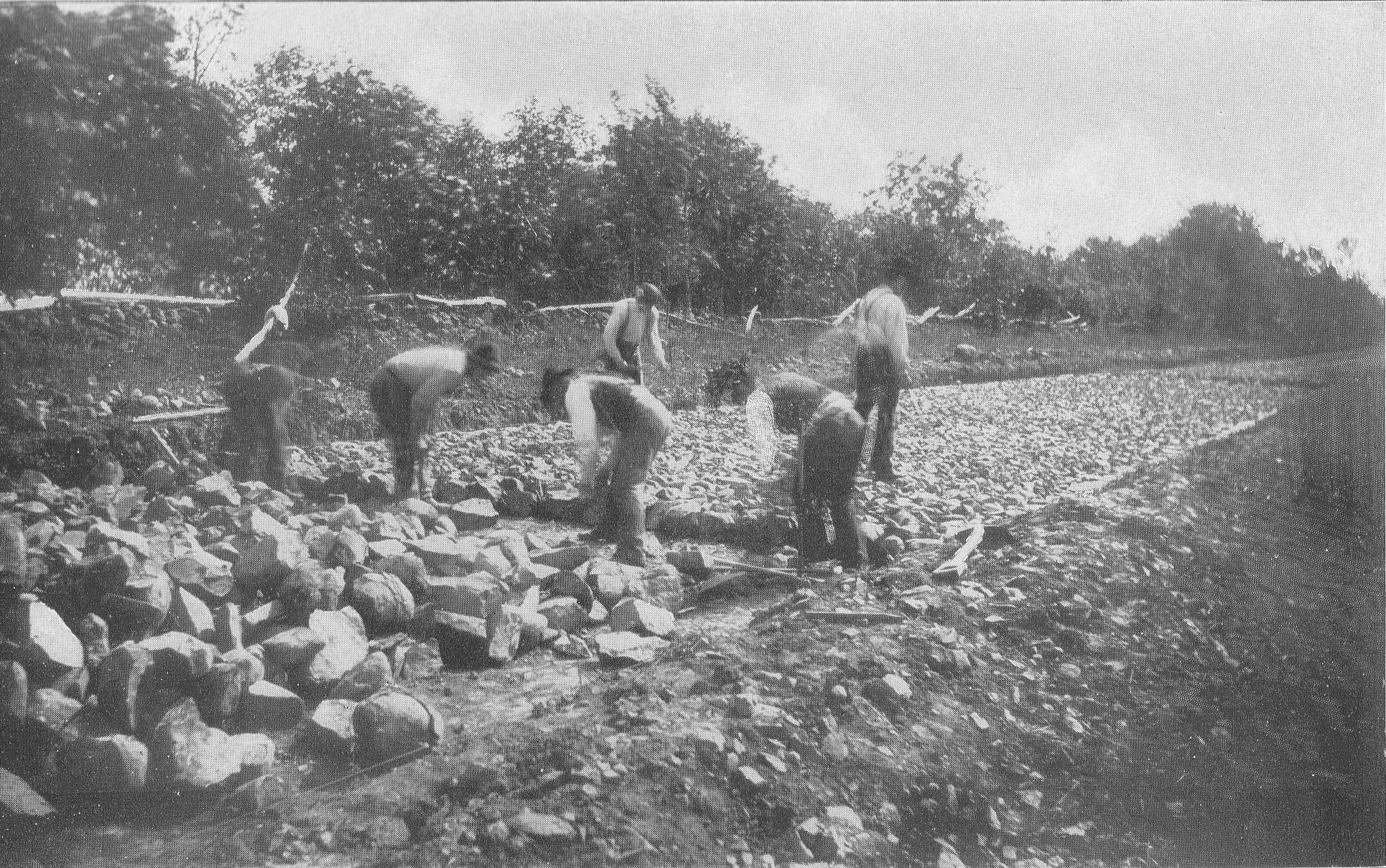
This image is titled “Putting 1 1/2 Inch Stone On Section 4 Confederate Avenue.” The location is West Confederate Avenue on Seminary Ridge. Section 4 of Confederate Avenue went from “Wheatfield Road to Emmitsburg road, 3700 feet.” The 1894 commission report states: “From the 13th to 21st of April a majority of those having received specifications for section 4 of the avenue for the purpose of viewing the locality, and were taken over the ground, and on the 21st five bids were handed in, namely Slayor & Boyer, Harrisburg, Pa.; B.B. Gonder, Strausburg, Pa.; Farrell & Bro., Westchester, Pa.; Richard W. Johnson, Wayne, Pa., and P. McManus, Philadelphia, Pa.” (pages 14-15 Editors Note: The commission report did not say who got the bid). The 1895 commission report states, “At the date when our report as the Battlefield Commission was made last year the only roadway in process of construction was section 4 of the Confederate avenue, from the Wheatfield road to the Emmitsburg road along Seminary Ridge… All these avenues have been and are being constructed on the Telford system, which was adopted after full consideration and study of the subject as promising the best results in solidity and durability. The stone used is syenitic granite and ironstone, very hard and of excellent quality. A foundation pavement is laid of 8-inch wedgelike stones set on edge and well knapped and chinked; on this 4 inches of stone 1 1/2 inches in size; then a slight layer of clay as a binder, and finally a top dressing of 1 or 2 inches of quarter-inch stone screenings; the whole rolled thoroughly with a steam roller weighing 14 tons; side and under drains are placed where needed. The results of the above method and process are roadways smooth and solid and which will last for generations.” (page 21) This view was taken circa 1894. Annual Reports of the Gettysburg National Military Park Commission to the Secretary of War, 1893-1904. Washington. Government Printing Office, 1905.
This image is titled “Section 4 Confederate Avenue, From Emmitsburg Road.” The location is the intersection of West Confederate Avenue with the Emmitsburg Road Section 4 of Confederate Avenue went from “Wheatfield Road to this location, the Emmitsburg road, 3700 feet.” The 1894 commission report states: “From the 13th to 21st of April a majority of those having received specifications for section 4 of the avenue for the purpose of viewing the locality, and were taken over the ground, and on the 21st five bids were handed in, namely Slayor & Boyer, Harrisburg, Pa.; B.B. Gonder, Strausburg, Pa.; Farrell & Bro., Westchester, Pa.; Richard W. Johnson, Wayne, Pa., and P. McManus, Philadelphia, Pa.” (pages 14-15 Editors Note: The commission report did not say who got the bid). The 1895 commission report states, “At the date when our report as the Battlefield Commission was made last year the only roadway in process of construction was section 4 of the Confederate avenue, from the Wheatfield road to the Emmitsburg road along Seminary Ridge… All these avenues have been and are being constructed on the Telford system, which was adopted after full consideration and study of the subject as promising the best results in solidity and durability. The stone used is syenitic granite and ironstone, very hard and of excellent quality. A foundation pavement is laid of 8-inch wedgelike stones set on edge and well knapped and chinked; on this 4 inches of stone 1 1/2 inches in size; then a slight layer of clay as a binder, and finally a top dressing of 1 or 2 inches of quarter-inch stone screenings; the whole rolled thoroughly with a steam roller weighing 14 tons; side and under drains are placed where needed. The results of the above method and process are roadways smooth and solid and which will last for generations.” (page 21) The Philip Snyder House is the light colored structure in the right background. The Emmitsburg Road is the dirt road running left to right. This view was taken facing northwest circa 1894. Annual Reports of the Gettysburg National Military Park Commission to the Secretary of War, 1893-1904. Washington. Government Printing Office, 1905.

This image is titled “Grading Section 5 Confederate Avenue Emmitsburg Road.” The location is the intersection of West Confederate Avenue with the Emmitsburg Road. The 1895 commission report states, “At the date when our report as the Battlefield Commission was made last year the only roadway in process of construction was section 4 of the Confederate avenue, from the Wheatfield road to the Emmitsburg road along Seminary Ridge. During the present year there have been constructed sections 5, 6, and 7 of Confederate avenue extending south from the Emmitsburg road to the southern limits of the battlefield, thence eastward crossing Plum Run, and up along the west slope of Rount Top to Kilpatrick avenue… All these avenues have been and are being constructed on the Telford system, which was adopted after full consideration and study of the subject as promising the best results in solidity and durability. The stone used is syenitic granite and ironstone, very hard and of excellent quality. A foundation pavement is laid of 8-inch wedgelike stones set on edge and well knapped and chinked; on this 4 inches of stone 1 1/2 inches in size; then a slight layer of clay as a binder, and finally a top dressing of 1 or 2 inches of quarter-inch stone screenings; the whole rolled thoroughly with a steam roller weighing 14 tons; side and under drains are placed where needed. The results of the above method and process are roadways smooth and solid and which will last for generations.” (page 21) The Philip Snyder House is the light colored structure in the right background. The Emmitsburg Road is the dirt road running left to right. West Confederate Avenue is being graded as it runs “away” from the camera, on the right of (west of) the stone wall. This view was taken facing south circa 1895. Annual Reports of the Gettysburg National Military Park Commission to the Secretary of War, 1893-1904. Washington. Government Printing Office, 1905.
This image is titled “Grading Roadbed, Section 1, Confederate Avenue. The location is West Confederate Avenue on Seminary Ridge. Section 1 of Confederate Avenue went from “Blocher’s House to Codori Line, 3700 feet.” (page 14). The 1894 commission report states: “From the 13th to 21st of April a majority of those having received specifications for section 4 of the avenue for the purpose of viewing the locality, and were taken over the ground, and on the 21st five bids were haned in, namely Slayor & Boyer, Harrisburg, Pa.; B.B. Gonder, Strausburg, Pa.; Farrell & Bro., Westchester, Pa.; Richard W. Johnson, Wayne, Pa., and P. McManus, Philadelphia, Pa.” (pages 14-15 Editors Note: The commission report did not say who got the bid). The 1895 commission report states, “At the date when our report as the Battlefield Commission was made last year the only roadway in process of construction was section 4 of the Confederate avenue, from the Wheatfield road to the Emmitsburg road along Seminary Ridge… All these avenues have been and are being constructed on the Telford system, which was adopted after full consideration and tudy of the subject as promising the best results in solidity and durability. The stone used is syenitic granite and ironstone, very hard and of excellent quality. A foundation pavement is laid of 8-inch wedgelike stones set on edge and well knapped and chinked; on this 4 inches of stone 1 1/2 inches in size; then a slight layer of clay as a binder, and finally a top dressing of 1 or 2 inches of quarter-inch stone screenings; the whole rolled thoroughly with a steam roller weighing 14 tons; side and under drains are placed where needed. The results of the above method and process are roadways smooth and solid and which will last for generations.” (page 21) The 1896 Commission report states: “Since our report of 1895 the Telford road, known as Seminary avenue, and section 1 of Confederate avenue, running from the Chambersburg pike southward along Seminary Ridge as far as the Government at present owns the right of way there, has been completed (page 29). This view was taken facing south circa 1896. Annual Reports of the Gettysburg National Military Park Commission to the Secretary of War, 1893-1904. Washington. Government Printing Office, 1905.
This image is titled “Rolling Subgrade, Section 1, Confederate Avenue.” The location is West Confederate Avenue on Seminary Ridge. Section 1 of Confederate Avenue went from “Blocher’s House to Codori Line, 3700 feet.” (page 14). The 1894 commission report states: “From the 13th to 21st of April a majority of those having received specifications for section 4 of the avenue for the purpose of viewing the locality, and were taken over the ground, and on the 21st five bids were handed in, namely Slayor & Boyer, Harrisburg, Pa.; B.B. Gonder, Strausburg, Pa.; Farrell & Bro., Westchester, Pa.; Richard W. Johnson, Wayne, Pa., and P. McManus, Philadelphia, Pa.” (pages 14-15 Editors Note: The commission report did not say who got the bid). The 1895 commission report states, “At the date when our report as the Battlefield Commission was made last year the only roadway in process of construction was section 4 of the Confederate avenue, from the Wheatfield road to the Emmitsburg road along Seminary Ridge… All these avenues have been and are being constructed on the Telford system, which was adopted after full consideration and tudy of the subject as promising the best results in solidity and durability. The stone used is syenitic granite and ironstone, very hard and of excellent quality. A foundation pavement is laid of 8-inch wedgelike stones set on edge and well knapped and chinked; on this 4 inches of stone 1 1/2 inches in size; then a slight layer of clay as a binder, and finally a top dressing of 1 or 2 inches of quarter-inch stone screenings; the whole rolled thoroughly with a steam roller weighing 14 tons; side and under drains are placed where needed. The results of the above method and process are roadways smooth and solid and which will last for generations.” (page 21) The 1896 Commission report states: “Since our report of 1895 the Telford road, known as Seminary avenue, and section 1 of Confederate avenue, running from the Chambersburg pike southward along Seminary Ridge as far as the Government at present owns the right of way there, has been completed (page 29). This view must show where the government property ended on West Confederate Avenue at the “Codori Line.” This view was taken facing southeast? circa 1896. Annual Reports of the Gettysburg National Military Park Commission to the Secretary of War, 1893-1904. Washington. Government Printing Office, 1905.

This image is titled “Foundation Work of Roadway on Seminary Avenue, Looking North.” The location is Seminary Avenue on Seminary Ridge. The Krauth House is in the right background. The 1894 commission report states: “From the 13th to 21st of April a majority of those having received specifications for section 4 of the avenue for the purpose of viewing the locality, and were taken over the ground, and on the 21st five bids were handed in, namely Slayor & Boyer, Harrisburg, Pa.; B.B. Gonder, Strausburg, Pa.; Farrell & Bro., Westchester, Pa.; Richard W. Johnson, Wayne, Pa., and P. McManus, Philadelphia, Pa.” (pages 14-15 Editors Note: The commission report did not say who got the bid). The 1895 commission report states, “At the date when our report as the Battlefield Commission was made last year the only roadway in process of construction was section 4 of the Confederate avenue, from the Wheatfield road to the Emmitsburg road along Seminary Ridge… All these avenues have been and are being constructed on the Telford system, which was adopted after full consideration and tudy of the subject as promising the best results in solidity and durability. The stone used is syenitic granite and ironstone, very hard and of excellent quality. A foundation pavement is laid of 8-inch wedgelike stones set on edge and well knapped and chinked; on this 4 inches of stone 1 1/2 inches in size; then a slight layer of clay as a binder, and finally a top dressing of 1 or 2 inches of quarter-inch stone screenings; the whole rolled thoroughly with a steam roller weighing 14 tons; side and under drains are placed where needed. The results of the above method and process are roadways smooth and solid and which will last for generations.” (page 21) The 1896 Commission report states: “Since our report of 1895 the Telford road, known as Seminary avenue, and section 1 of Confederate avenue, running from the Chambersburg pike southward along Seminary Ridge as far as the Government at present owns the right of way there, has been completed (page 29). Annual Reports of the Gettysburg National Military Park Commission to the Secretary of War, 1893-1904. Washington. Government Printing Office, 1905.
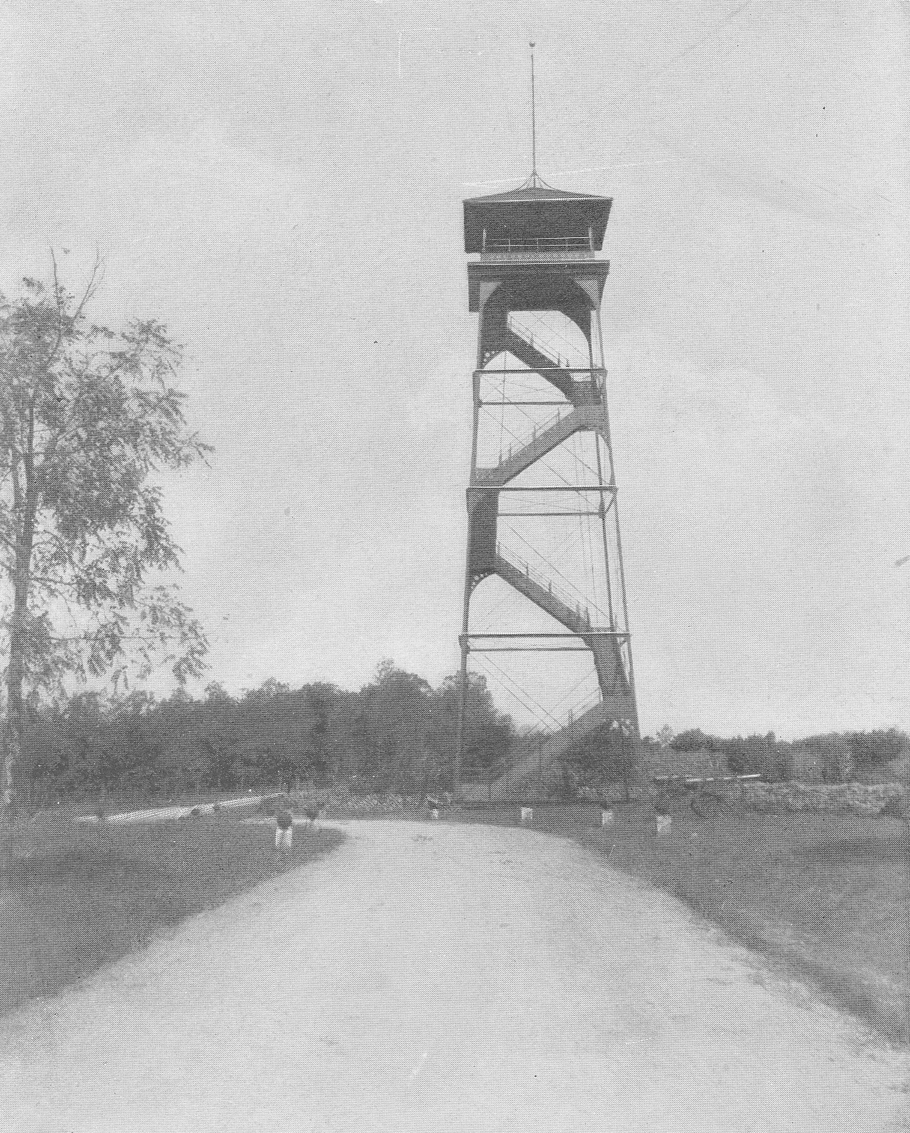
This image is titled “Tower, Confederate Avenue, Section 4.” The location is West Confederate Avenue on Seminary Ridge. The Longstreet Tower/Eisenhower Tower is featured. Section 4 of Confederate Avenue went from “Wheatfield Road to Emmitsburg road, 3700 feet.” The 1894 commission report states: “From the 13th to 21st of April a majority of those having received specifications for section 4 of the avenue for the purpose of viewing the locality, and were taken over the ground, and on the 21st five bids were handed in, namely Slayor & Boyer, Harrisburg, Pa.; B.B. Gonder, Strausburg, Pa.; Farrell & Bro., Westchester, Pa.; Richard W. Johnson, Wayne, Pa., and P. McManus, Philadelphia, Pa.” (pages 14-15 Editors Note: The commission report did not say who got the bid). The 1895 commission report states, “At the date when our report as the Battlefield Commission was made last year the only roadway in process of construction was section 4 of the Confederate avenue, from the Wheatfield road to the Emmitsburg road along Seminary Ridge… All these avenues have been and are being constructed on the Telford system, which was adopted after full consideration and study of the subject as promising the best results in solidity and durability. The stone used is syenitic granite and ironstone, very hard and of excellent quality. A foundation pavement is laid of 8-inch wedgelike stones set on edge and well knapped and chinked; on this 4 inches of stone 1 1/2 inches in size; then a slight layer of clay as a binder, and finally a top dressing of 1 or 2 inches of quarter-inch stone screenings; the whole rolled thoroughly with a steam roller weighing 14 tons; side and under drains are placed where needed. The results of the above method and process are roadways smooth and solid and which will last for generations.” (page 21) At one time there were five observation towers at Gettysburg National Military Park. Tower #1 was 60 feet tall and was located on Big Round Top. Tower #2 is 75 feet tall and is located on Seminary Ridge. It is known as the Longstreet Tower and is pictured here. Tower #3 used to be 75 feet tall until it was cut down to its current size. It is the Oak Ridge Tower near the Mummasburg Road. Tower #4 is 60 feet tall and is located on Culp’s Hill. The first four towers were constructed in 1895. The Ziegler’s Grove Tower was constructed in 1896, and must have been known as Tower #5. “These are all solid and well-built structures, and located as they are, they afford the observer a complete and satisfactory view of the entire scene of the great battle and enable him to get a consistent and accurate idea of it as a whole.” (Gettysburg National Military Park Commission report pages 22, 30-31) The cannon at the bottom of the tower are 20 Pounder Parrotts which mark the position of Woolfolk’s Battery, The Ashland Virginia Artillery. This view was taken facing northwest circa 1896. Annual Reports of the Gettysburg National Military Park Commission to the Secretary of War, 1893-1904. Washington. Government Printing Office, 1905.